St. Cloud, Minnesota
| St. Cloud, Minnesota | |
|---|---|
| City | |
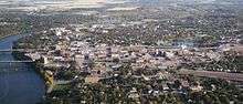
 Buildings on 5th Avenue in downtown St. Cloud (2008) | |
| Nickname(s): "The Granite City" | |
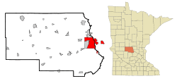 Location of the city of St. Cloud within Stearns, Benton, and Sherburne Counties in the state of Minnesota | |
| Coordinates: 45°33′N 94°10′W / 45.550°N 94.167°WCoordinates: 45°33′N 94°10′W / 45.550°N 94.167°W | |
| Country | United States |
| State | Minnesota |
| Counties | Stearns, Benton, Sherburne |
| Founded | 1856[1] |
| Government | |
| • Mayor | Dave Kleis |
| Area[2] | |
| • City | 41.08 sq mi (106.40 km2) |
| • Land | 40.04 sq mi (103.70 km2) |
| • Water | 1.04 sq mi (2.69 km2) |
| Elevation | 1,030 ft (314 m) |
| Population (2010)[3] | |
| • City | 65,842 |
| • Estimate (2016)[4] | 67,641 |
| • Rank | US: 525th MN: 10th |
| • Density | 1,600/sq mi (620/km2) |
| • Urban | 110,621 (US: 281st) |
| • Metro | 194,418 (US: 222nd) |
| Time zone | UTC−6 (CST) |
| • Summer (DST) | UTC−5 (CDT) |
| ZIP codes | 56301, 56302, 56303, 56304, 56393, 56397, 56398 |
| Area code(s) | 320 |
| FIPS code | 27-56896 |
| GNIS feature ID | 2396483[5] |
| Website | www.ci.stcloud.mn.us |
St. Cloud is a city in the U.S. state of Minnesota and the largest population center in the state's central region. Its population is 67,984 according to the 2017 US census estimates, making it Minnesota's tenth largest city.[6] St. Cloud is the county seat of Stearns County[7] and was named after the city of Saint-Cloud, France (in Île-de-France, near Paris), which was named after the 6th-century French monk Clodoald.
Though mostly in Stearns County, St. Cloud also extends into Benton and Sherburne counties, and straddles the Mississippi River. It is the center of a small, contiguous urban area totaling over 120,000 residents, with Waite Park, Sauk Rapids, Sartell, St. Joseph, Rockville, and St. Augusta directly bordering the city, and Foley, Rice, Kimball, Clearwater, Clear Lake, and Cold Spring nearby. With 189,093 residents at the 2010 census, the St. Cloud metropolitan area is the fourth-largest in Minnesota, behind Minneapolis–St. Paul, Duluth–Superior, and Rochester. (The population of Fargo-Moorhead is also larger than St. Cloud's, but most of that is in North Dakota, with only 58,999 residents in Minnesota.)
St. Cloud is 65 miles (105 km) northwest of the Twin Cities of Minneapolis–St. Paul along Interstate 94, U.S. Highway 10, and Minnesota State Highway 23. The St. Cloud Metropolitan Statistical Area (MSA) is made up of Stearns and Benton Counties.[8] The city was included in a newly defined Minneapolis–St. Paul–St. Cloud Combined Statistical Area (CSA) in 2000. St. Cloud as a whole has never been part of the 13-county MSA comprising Minneapolis, St. Paul, Bloomington and parts of western Wisconsin,[9] although its Sherburne County portion is considered part of the Twin Cities metropolitan area by Census Bureau definition.
St. Cloud State University, Minnesota's third-largest public university, is located between the downtown area and the Beaver Islands, which form a maze for a two-mile stretch of the Mississippi. The approximately 30 undeveloped islands are a popular destination for kayak and canoe enthusiasts[10] and are part of a state-designated 12-mile stretch of wild and scenic river.[11]
St. Cloud owns and operates a hydroelectric dam on the Mississippi that can produce up to nine megawatts of electricity.[12][13]
History
What is now the St. Cloud area was occupied by various indigenous peoples for thousands of years. Europeans encountered the Ottawa, Ojibwe, and Winnebago when they started to trade with Native American peoples.
Minnesota was organized as a territory in 1849. The St. Cloud area was opened up to settlers in 1851[14] after treaty negotiations with the Winnebago (Ho-Chunk) tribe in 1851 and 1852. John Wilson, a Maine native with French Huguenot ancestry and an interest in Napoleon, named the settlement St. Cloud after Saint-Cloud, the Paris suburb where Napoleon had his favorite palace.
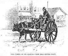
St. Cloud was a waystation on the Middle and Woods branches of the Red River Trails used by Métis traders between the Canada–US border at Pembina, North Dakota and St. Paul. The cart trains often consisted of hundreds of oxcarts. The Métis, bringing furs to trade for supplies to take back to their rural settlements, would camp west of the city and cross the Mississippi in St. Cloud or just to the north in Sauk Rapids
The City of St. Cloud was incorporated in 1856. It developed from three distinct settlements, known as Upper Town, Middle Town, and Lower Town, that were established by European-American settlers starting in 1853.[15] Remnants of the deep ravines that separated the three are still visible today. Middle Town was settled primarily by Catholic German immigrants and migrants from eastern states, who were recruited to the region by Father Francis Xavier Pierz, a Catholic priest who also ministered as a missionary to Native Americans. Lower Town was founded by settlers from the Northern Tier of New England and the mid-Atlantic states, including former residents of upstate New York.
Upper Town, or Arcadia, was plotted by General Sylvanus Lowry, a slaveholder and trader from Kentucky who brought slaves with him, although Minnesota was organized as a free territory.[16] He served on the territorial Council from 1852 to 1853 and was elected St. Cloud's first mayor in 1856, serving for one year.[16][17]
Jane Grey Swisshelm, an abolitionist newspaper editor who had migrated from Pittsburgh, repeatedly attacked Lowry in print. At one point he organized a "Committee of Vigilance" that broke into Swisshelm's newspaper office and removed her press, throwing it into the Mississippi River. Lowry started a rival paper, The Union.[17]
The US Supreme Court's 1857 decision in the Dred Scott case ruled that slaves could not file freedom suits, as well as declaring the Missouri Compromise unconstitutional, so the territory's prohibition against slavery became unenforceable. Nearly all Southerners left the St. Cloud area when the Civil War broke out, taking their slaves with them.[17] Lowry died in the city in 1865.[18]
Beginning in 1864, Stephen Miller served a two-year term as Minnesota governor, the only citizen of St. Cloud ever to hold the office. Miller was a "Pennsylvania German businessman", lawyer, writer, active abolitionist, and personal friend of Alexander Ramsey. He was on the state's Republican electoral ticket with Abraham Lincoln in 1860.[19]
Steamboats regularly docked at St. Cloud as part of the fur trade and other commerce, although river levels were not reliable. This ended with the construction of the Coon Rapids Dam in 1912–14. Granite quarries have operated in the area since the 1880s, giving St. Cloud its nickname, "The Granite City."
In 1917, Samuel Pandolfo started the Pan Motor Company in St. Cloud. Pandolfo claimed his Pan-Cars would make St. Cloud the new Detroit. He was later convicted and imprisoned for attempting to defraud investors.[20][21]
Geography
According to the United States Census Bureau, the city has a total area of 41.08 square miles (106.40 km2); 40.04 square miles (103.70 km2) is land and 1.04 square miles (2.69 km2) is water.[2] The city is bisected by the Mississippi River, and part of the Sauk River runs along its northern edge. Just south of downtown, near Technical High School, is the 7-acre, 35-feet-deep Lake George.
Adjacent communities
- Sartell – north
- Sauk Rapids – northeast
- St. Augusta – south
- Waite Park – west-southwest
- Rockville – southwest
- St. Joseph – west
Climate
St. Cloud lies in the warm summer humid continental climate zone (Köppen climate classification Dfb), with hot, humid summers and cold winters with moderate to heavy snowfall. The monthly normal daily mean temperature ranges from 11.6 °F (−11.3 °C) in January to 70.3 °F (21.3 °C) in July.[22]
| Climate data for St. Cloud Regional Airport, Minnesota (1981–2010 normals,[23] extremes 1894–present) | |||||||||||||
|---|---|---|---|---|---|---|---|---|---|---|---|---|---|
| Month | Jan | Feb | Mar | Apr | May | Jun | Jul | Aug | Sep | Oct | Nov | Dec | Year |
| Record high °F (°C) | 56 (13) |
59 (15) |
81 (27) |
96 (36) |
105 (41) |
102 (39) |
107 (42) |
105 (41) |
106 (41) |
90 (32) |
75 (24) |
63 (17) |
107 (42) |
| Mean maximum °F (°C) | 42.9 (6.1) |
46.0 (7.8) |
61.6 (16.4) |
79.1 (26.2) |
88.1 (31.2) |
92.4 (33.6) |
93.3 (34.1) |
91.7 (33.2) |
86.9 (30.5) |
78.7 (25.9) |
59.7 (15.4) |
43.6 (6.4) |
95.7 (35.4) |
| Average high °F (°C) | 21.4 (−5.9) |
26.8 (−2.9) |
39.0 (3.9) |
56.3 (13.5) |
68.8 (20.4) |
77.5 (25.3) |
82.3 (27.9) |
79.6 (26.4) |
70.3 (21.3) |
56.6 (13.7) |
39.0 (3.9) |
24.7 (−4.1) |
53.7 (12.1) |
| Average low °F (°C) | 1.8 (−16.8) |
7.2 (−13.8) |
19.8 (−6.8) |
32.7 (0.4) |
44.2 (6.8) |
53.6 (12) |
58.4 (14.7) |
56.0 (13.3) |
46.8 (8.2) |
34.9 (1.6) |
21.7 (−5.7) |
7.1 (−13.8) |
32.1 (0.1) |
| Mean minimum °F (°C) | −23.1 (−30.6) |
−17.4 (−27.4) |
−3.9 (−19.9) |
17.0 (−8.3) |
29.4 (−1.4) |
39.5 (4.2) |
46.0 (7.8) |
42.7 (5.9) |
29.8 (−1.2) |
18.8 (−7.3) |
2.0 (−16.7) |
−17.3 (−27.4) |
−26.7 (−32.6) |
| Record low °F (°C) | −43 (−42) |
−40 (−40) |
−32 (−36) |
−3 (−19) |
18 (−8) |
32 (0) |
40 (4) |
33 (1) |
18 (−8) |
5 (−15) |
−23 (−31) |
−41 (−41) |
−43 (−42) |
| Average precipitation inches (mm) | 0.65 (16.5) |
0.59 (15) |
1.55 (39.4) |
2.57 (65.3) |
2.95 (74.9) |
4.17 (105.9) |
3.31 (84.1) |
3.79 (96.3) |
3.46 (87.9) |
2.49 (63.2) |
1.38 (35.1) |
0.82 (20.8) |
27.73 (704.3) |
| Average snowfall inches (cm) | 8.6 (21.8) |
7.0 (17.8) |
8.5 (21.6) |
3.0 (7.6) |
trace | 0 (0) |
0 (0) |
0 (0) |
trace | 0.8 (2) |
8.4 (21.3) |
9.4 (23.9) |
45.7 (116.1) |
| Average precipitation days (≥ 0.01 in) | 7.4 | 6.4 | 8.2 | 9.1 | 10.9 | 12.1 | 10.5 | 9.3 | 9.9 | 9.3 | 7.8 | 7.6 | 108.5 |
| Average snowy days (≥ 0.1 in) | 8.1 | 6.2 | 5.2 | 1.8 | 0.1 | 0 | 0 | 0 | 0 | 0.8 | 5.0 | 8.2 | 35.4 |
| Source: NOAA[22][24] | |||||||||||||
Demographics
| Historical population | |||
|---|---|---|---|
| Census | Pop. | %± | |
| 1870 | 2,181 | — | |
| 1880 | 2,482 | 13.8% | |
| 1890 | 7,086 | 185.5% | |
| 1900 | 8,683 | 22.5% | |
| 1910 | 10,600 | 22.1% | |
| 1920 | 15,873 | 49.7% | |
| 1930 | 21,000 | 32.3% | |
| 1940 | 24,173 | 15.1% | |
| 1950 | 28,410 | 17.5% | |
| 1960 | 32,415 | 14.1% | |
| 1970 | 39,691 | 22.4% | |
| 1980 | 42,566 | 7.2% | |
| 1990 | 48,812 | 14.7% | |
| 2000 | 59,108 | 21.1% | |
| 2010 | 65,842 | 11.4% | |
| Est. 2016 | 67,641 | [4] | 2.7% |
| U.S. Decennial Census[25] 2015 Estimate[26] | |||
2010 census
As of the census[3] of 2010, there were 65,842 people, 25,439 households, and 13,348 families residing in the city. The population density was 1,644.4 inhabitants per square mile (634.9/km2). There were 27,338 housing units at an average density of 682.8 per square mile (263.6/km2). The racial makeup of the city was 84.6% White, 7.8% African American, 0.7% Native American, 3.7% Asian, 0.8% from other races, and 2.5% from two or more races. Hispanic or Latino of any race were 2.4% of the population.
There were 25,439 households of which 25.0% had children under the age of 18 living with them, 37.6% were married couples living together, 10.4% had a female householder with no husband present, 4.5% had a male householder with no wife present, and 47.5% were non-families. 30.8% of all households were made up of individuals and 7.8% had someone living alone who was 65 years of age or older. The average household size was 2.37 and the average family size was 2.95.
The median age in the city was 28.8 years.[27] 18.9% of residents were under the age of 18; 23.9% were between the ages of 18 and 24; 25.5% were from 25 to 44; 21.5% were from 45 to 64; and 10.3% were 65 years of age or older. The gender makeup of the city was 51.5% male and 48.5% female.
2000 census
St. Cloud is the principal city of the St. Cloud Metropolitan Statistical Area, a metropolitan area that covers Sherburne, Benton and Stearns counties and had a combined population of 167,392 at the 2000 census.
In the 2000 census,[28] 27.3% of St. Cloud households had children under the age of 18 living with them, 41.4% were married couples living together, 9.4% had a female householder with no husband present, and 45.9% were non-families. 30.2% of all households were made up of individuals and 8.0% had someone living alone who was 65 years of age or older. The average household size was 2.40 and the average family size was 3.00.
The racial makeup of the city was 91.7% White, 2.4% African American, 0.7% Native American, 3.1% Asian, 0.7% other races, and 1.4% from two or more races. Hispanic or Latino of any race were 1.3% of the population.
The median income for a household in the city was $37,346, and the median income for a family was $50,460. Males had a median income of $33,670 versus $23,759 for females. The per capita income for the city was $19,769. About 5.0% of families and 13.1% of the population were below the poverty line, including 7.0% of those under age 18 and 9.9% of those age 65 or over.
Economy
Top employers
According to St. Cloud's 2011 Comprehensive Annual Financial Report,[29] the top employers in the city are:
| # | Employer | # of Employees |
|---|---|---|
| 1 | CentraCare Health System / St. Cloud Hospital | 4,110 |
| 2 | State of Minnesota / St. Cloud State University | 2,036 |
| 3 | St. Cloud VA Medical Center | 1,360 |
| 4 | Electrolux Home Products | 1,259 |
| 5 | St. Cloud School District | 828 |
| 6 | New Flyer Industries | 530 |
| 7 | Wolters Kluwer Financial Services | 525 |
| 8 | Capital One | 495 |
| 9 | Bluestem Fulfillment | 484 |
| 10 | City of St. Cloud | 438 |
Arts and culture
Sites of interest
- Cathedral of Saint Mary, the largest church serving the oldest parish in the community, built in the 1920s in the Italian Romanesque style. The Cathedral is the mother church of the Roman Catholic Diocese of Saint Cloud.
- The St. Cloud Central Business District is listed on the National Register of Historic Places. St. Cloud is a Preserve America Community.[30]
- St. Cloud State University, with 16,457 students from about 80 nations.
- Great River Regional Library, a six-county regional system serving 32 communities. A new main library building opened in St. Cloud in September 2008.
- Munsinger Gardens and Clemens Gardens, extensive flower gardens dating from the 1930s.
- Quarry Park, a unique public park that features 20 granite quarries, hiking, biking and ski trails. Part of the Stearns County park system.
- Paramount Theatre and Visual Arts Center, a restored 706-seat theater, built in 1921.[31]
- St. Cloud Hospital, part of CentraCare Health, was founded in 1886 as St. Benedict's Hospital. The regional health system includes five smaller hospitals and numerous outreach and outpatient clinics and services.
- Stearns County History Museum, with two floors of exhibits, a research area, a museum store, and a 100-acre (0.40 km2) nature park. The only county museum in Minnesota accredited by the American Alliance of Museums.
- Minnesota Amateur Baseball Hall of Fame, dedicated to preserving Minnesota's baseball history.
- St. Cloud River's Edge Convention Center, a 100,000-square-foot (9,300 m2) meeting center overlooking the Mississippi River.
- St. Cloud Regional Airport, providing scheduled commercial turboprop passenger service, private, corporate, cargo and military operations.
- St. Cloud Technical & Community College, a member of the Minnesota State Colleges and Universities System.
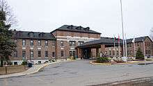
- Minnesota Correctional Facility – St. Cloud, built in 1889, housing nearly 1,000 prisoners.
- Midtown Square Mall, a shopping mall with more than 50 tenants
- Crossroads Center, a shopping mall with more than 100 tenants
Sports
The city is home to:
- the St. Cloud State University Division I ice hockey teams. Men's Husky Hockey competes in the National Collegiate Hockey Conference. Women's Husky Hockey competes in the Western Collegiate Hockey Association. The men's team has made nine NCAA Men's Ice Hockey Championship appearances, notably advancing to the 2013 Frozen Four in Pittsburgh, Penn.[32] The 2012-13 team's co-captain and fifth-year forward, Drew LeBlanc, was named WCHA Player of the Year and earned numerous national honors, including the Hobey Baker Award, the most prestigious award in men's college hockey.[33] The 2013 team earned also earned a share of the WCHA league title and its symbol, the century-old MacNaughton Cup.[34] The Huskies play in the 5,763-seat Herb Brooks National Hockey Center, which underwent a $18 million renovation and expansion in 2012-13.[35]
- the Granite City Lumberjacks, a tier III hockey team.
- the St. Cloud Rox (formerly the River Bats) of the Northwoods League, a collegiate summer baseball league. The Rox play at Joe Faber Field in St. Cloud and were founded in 2012.
- the Saint Cloud Area Roller Dolls, a flat-track roller derby league founded in 2011.[36]
Parks and recreation
The city maintains 95 parks, totaling more than 1,400 acres (5.7 km2) and ranging in size from 80 "neighborhood and mini parks" to 243 acres (0.98 km2). The largest developed park, Whitney Memorial Park, is the former location of the city airport. It features a recreation center for senior citizens, a dog park, and numerous softball, baseball, and soccer fields.
Government
The mayor of St. Cloud is Dave Kleis, who won reelection in 2012 running unopposed. St. Cloud is in Minnesota's 6th congressional district, represented by Tom Emmer (R). St. Cloud is partly in Minnesota House of Representatives district 14A, represented by Tama Theis (R), and partly in 14B, represented by Jim Knoblach (R). State Senate District 14 is represented by vice chair of the state capital investment committee John Pederson (R).
In the 2008 presidential election, Barack Obama and Joe Biden won 54% of the vote in the city, and John McCain and Sarah Palin 46%.[37]
Past mayors of St. Cloud include Sylvanus B. Lowry (1856), John L. Wilson (1857–58), E. O. Hamlin (1868), J. A. McDonald (1900), J. R. Boyd (1901), J. E. C. Robinson (1902–05 and 1906), J. N. Bensen (1905), David McCarty (1907), Louis Brown (1907), Hugh Evans (1908–09), D. H. Freeman (1910 and 1916–19), P. J. Seberger (1911–12), H. J. Limperich (1919), W. W. Matson (1920–24), J. Arthur Bensen (1924–28), James H. Murphy (1928–32, 1945–48), Phil Collignon (1932–45), Mathew Malisheski (1948–52), Lawrence A. Borgert (1952), George Byers (1953–60), Thomas E. Mealey (1960–64), Ed Henry (1964–71), Al Loehr (1971–80), Sam Huston (1980–89), Chuck Winkelman (1989–97), Larry Meyer (1997–2001), and John Ellenbecker (2001–05).
Education
The city of St. Cloud is part of the St. Cloud Area School District, which serves St. Cloud, St. Augusta, Clearwater, Waite Park, St. Joseph, and Haven Township. The district has eight elementary schools, a new K-8 school in St. Joseph, and two major public high schools, St. Cloud Technical High School and St. Cloud Apollo High School.[38] St. Cloud also has a major private high school, Cathedral High School. Both public high schools offer a broad selection of Advanced Placement courses, and rank high in the state in number of AP tests taken and of test takers.[39] St. Cloud Tech is the older of the two, opening in 1917, and is just west of downtown on the city's south side. Apollo opened in 1970 and serves the expanding north side of the city. Other high schools and secondary schools that serve the city of St. Cloud include St. Robert Bellarmine's Academy, St. Cloud Christian School, Immaculate Conception Academy, St. John's Preparatory School, St. Cloud Alternative Learning Center, and charter school STRIDE Academy,[40] which is K-8. The nearby cities of Sauk Rapids and Sartell also have their own school districts and high schools, bringing the number of public high schools in the metropolitan area to four.
Colleges
St. Cloud is home to several higher education institutions, including Minnesota's third-largest university, St. Cloud State University. St. Cloud State's fall 2013 enrollment was 16,245, including 1,604 graduate students, 1,025 international students and 700 veteran students.[41]
Other post-secondary institutions and campuses in St. Cloud include St. Cloud Technical and Community College (SCTCC), Rasmussen College and Globe University/Minnesota School of Business. Neighboring Sartell is home to a campus of the Duluth-based College of St. Scholastica, and the College of St. Benedict and St. John's University are in neighboring St. Joseph and nearby Collegeville, respectively.[42]
Media
The main newspaper is the St. Cloud Times, a Gannett newspaper. The St. Cloud Diocese also publishes the St. Cloud Visitor, which serves the regional Catholic community.[43]
St. Cloud is part of the Twin Cities television market. One full-power station, KPXM-TV (channel 41), an Ion network affiliate, is licensed to the city. Low-power stations include WCMN (channel 13) which is not always on the air. Additionally, St. Cloud State University students operate cable-only UTVS (channel 180), which includes local news and broadcasts from a studio on campus.[44]
Radio stations include:
FM
AM
| AM radio stations | ||||
|---|---|---|---|---|
| Frequency | Call sign | Name | Format | Owner |
| 540 AM | WXYG | The Goat | Classic rock | Tri-County Broadcasting |
| 660 AM | WBHR | The Bear | Sports | Tri-County Broadcasting |
| 800 AM | WVAL | Classic Country | Tri-County Broadcasting | |
| 1010 AM | WMIN | Uptown 1010 | Adult Standards | Tri-County Broadcasting |
| 1180 AM | KYES | Relevant Radio | Catholic | Gabriel Media |
| 1240 AM | WJON | News/Talk | Townsquare Media | |
| 1390 AM | KXSS | The Fan | Sports | Townsquare Media |
| 1450 AM | KNSI | News/Talk | Leighton Broadcasting | |
Infrastructure
Transportation
St. Cloud is a regional transportation hub within Minnesota. Major roadways including Interstate Highway 94, U.S. Highway 10, and Minnesota State Highways 15 and 23 pass through the city.[45]
Bus service within the city and to neighboring Sartell, Sauk Rapids, and Waite Park is offered through St. Cloud Metro Bus, which was recognized in 2007 as the best transit system of its size in North America. An innovative system gives transit buses a slight advantage at stoplights in order to improve efficiency and on-time performance.[46] The Metro Bus Transit Center in the downtown area is also shared with Jefferson Lines, providing national bus service.
Bus service links downtown St. Cloud and St. Cloud State University with the western terminus of the Northstar Commuter Rail line in Big Lake, by the way of Northstar Link Commuter Bus, which in turn links to the Metro Transit bus and light rail system at Target Field Station in downtown Minneapolis.
Several rail lines run through the city, which is a stop on Amtrak's Empire Builder passenger rail line. St. Cloud is also home to St. Cloud Regional Airport, from which daily connecting flights to Minneapolis–Saint Paul International Airport were made on Delta Connection, operated by Mesaba Airlines, until January 1, 2010, when the service was discontinued. On December 15, 2012, Allegiant Air began nonstop flights between St. Cloud Regional Airport and Phoenix-Mesa Gateway Airport, on McDonnell Douglas MD-80 aircraft.[47]
Major highways
Notable people
- Halima Aden, model and first Somali-American to compete for Miss Minnesota; worked alongside Gigi Hadid, and modeled for Kanye West's fashion brand Yeezy Season 5
- Mathew Ahmann, civil rights activist
- Tom Burgmeier, Major League Baseball player; grew up in St. Cloud and attended Cathedral High School[48]
- Loren W. Collins, Minnesota jurist and legislator; mayor of St. Cloud
- David Durenberger, Former United States Senator from Minnesota
- Jim Eisenreich, Major League Baseball player for 1997 World Series champion Florida Marlins
- Howard M. Fish, retired U.S. Air Force lieutenant general, former assistant vice chief of staff of Air Force
- Charles A. Gilman, ninth Lieutenant Governor of Minnesota
- Janey Gohl, 1978 Miss Minnesota USA
- Lawrence M. Hall, longest-serving Speaker of the Minnesota House of Representatives
- Jim Knoblach, Republican member of the Minnesota House of Representatives
- June Marlowe, actress notable for playing Miss Crabtree in short-film series Our Gang
- Stephen Miller, abolitionist, Civil War veteran, Republican politician, fourth Governor of Minnesota
- Edgar G. Mills, Wisconsin State Assemblyman and Senator
- William P. Murphy, former Associate Justice of Minnesota Supreme Court
- Tom Petters, former CEO and chairman of Petters Group Worldwide,[49] convicted for involvement in a $3.65 billion Ponzi scheme[50]
- Reynold Philipsek, gypsy jazz guitarist
- Alise Post, BMX racer[51]
- Michael Sauer, professional ice hockey player for New York Rangers
- Nate Schmidt, professional ice hockey player for NHL's Vegas Golden Knights, Washington Capitals
- Stephen Sommers, film director and alumnus of Cathedral High School and St. John's University
- Charles Thomas Stearns, politician
- Jane Swisshelm, newspaper owner, editor and abolitionist
- Nate Wolters, professional basketball player for Utah Jazz
- Gig Young, Academy Award-winning actor, film and television star; born in St. Cloud
Sister cities
In popular culture
- Season 3 of FX's Fargo depicts St. Cloud as the residence of both Ray Stussy (Ewan McGregor) and Nikki Swango (Mary Elizabeth Winstead), but was not filmed there.
- Courtroom scenes in the Disney Film The Mighty Ducks were filmed in St. Cloud, and a few scenes were filmed at the Municipal Athletic Complex (MAC) but did not make the final film.
- Senator Al Franken and Tom Davis's One More Saturday Night is set in St. Cloud, but was not filmed there.
- Juno was partially set in St. Cloud, which is referred to as "East Jesus Nowhere", though no filming took place in the city.
- The song "On a Bus to St. Cloud", by Gretchen Peters, is on Trisha Yearwood's 1995 album Thinkin' About You.
- In 2005, Penn & Teller: Bullshit! shot an episode on the SCSU campus.
- In the 2007 horror movie 1408, St. Cloud is mentioned as one of the scariest places the protagonist has visited while investigating haunted houses.
- Judith Guest and Rebecca Hill's novel Killing Time in St. Cloud is set in the eponymous city.
- John Bellairs's character Mr. Emerson is from St. Cloud.
- In the novel The Death and Life of Charlie St. Cloud by Ben Sherwood, the main character's mother grew up in the city.
- In the sitcom How I Met Your Mother, Marshall Eriksen is from St. Cloud. Throughout the series, St. Cloud is visited by several characters several times, but is portrayed as a much smaller town than it is in reality.
- The post-hardcore band For All Those Sleeping formed in St. Cloud[53]
- The 1989 film Catch Me If You Can was shot in St. Cloud[54]
See also
References
- ↑ Dominik, John J. (1986). That You May Find Healing. St. Cloud, Minn: St. Cloud Hospital. p. 5.
- 1 2 "US Gazetteer files 2010". United States Census Bureau. Archived from the original on January 24, 2012. Retrieved November 13, 2012.
- 1 2 "American FactFinder". United States Census Bureau. Retrieved November 13, 2012.
- 1 2 "Population and Housing Unit Estimates". Retrieved June 9, 2017.
- ↑ "US Board on Geographic Names". United States Geological Survey. October 25, 2007. Retrieved January 31, 2008.
- ↑ http://mn.gov/admin/demography/data-by-topic/population-data/our-estimates/
- ↑ "Find a County". National Association of Counties. Retrieved June 7, 2011.
- ↑ "Area Definitions - Metropolitan Statistical Areas". Minnesota Department of Employment and Economic Development. Retrieved October 3, 2009.
- ↑ Metro Council website, Twin Cities Metropolican Area Geographic Definitions, "Definitions Used By The U.S. Census Bureau"
- ↑ Minnesota Department of Natural Resources, "Mississippi River", "St. Cloud to Anoka"
- ↑ "The Wild & Scenic Mississippi River". Minnesota Department of Natural Resources. Retrieved October 3, 2009.
- ↑ City of St. Cloud, Public Utilities, Hydroelectric Services
- ↑ John Weeks, John Weeks, The Bridges and Structures of the Mississippi River Headwaters, A Detailed Look At The Bridges, Dams And Other Structures On The Mississippi River In The Headwaters Region From Lake Itasca To Minneapolis, November 2007.
- ↑ Kevin Knight. "Diocese of Saint Cloud". New Advent. Retrieved April 5, 2013.
- ↑ "3 Towns Into 1 City, A Narrative Record of Significant Factors in The Story Of St. Cloud Minnesota."
- 1 2 "Sylvanus Lowry", Minnesota Legislators Past and Present, accessed 4 Juley 2012
- 1 2 3 Ambar Espinoza, "St. Cloud professor unearths history of slavery in Minnesota", Minnesota Public Radio, May 7, 2010, accessed July 4, 2012
- ↑ Our Gohman Story: The First and Second Generations ISBN 978-1-5049-0520-6 p. 173
- ↑ John J. Dominik Jr., "Three Towns Into One City," St. Cloud, Minnesota: St Cloud Area Bicentennial Commission, 1976, p. 13
- ↑ "Pan History". St Cloud Antique Auto Club, Inc. January 1, 2007. Retrieved June 20, 2007.
- ↑ "Automotive History Online, Pan Motor". Automotivehistoryonline.com. Retrieved November 6, 2011.
- 1 2 "NOWData – NOAA Online Weather Data". National Oceanic and Atmospheric Administration. Retrieved 2018-03-14.
- ↑ Mean monthly maxima and minima (i.e. the expected highest and lowest temperature readings at any point during the year or given month) calculated based on data at said location from 1981 to 2010.
- ↑ "Station Name: MN ST CLOUD RGNL AP". National Oceanic & Atmospheric Administration. Retrieved 2018-03-14.
- ↑ United States Census Bureau. "Census of Population and Housing". Retrieved June 15, 2013.
- ↑ "Annual Estimates of the Resident Population: April 1, 2010 to July 1, 2015". Archived from the original on October 19, 2016. Retrieved June 2, 2016.
- ↑ "St Cloud city, Minnesota". Profile of General Population and Housing Characteristics: 2010; 2010 Demographic Profile Data. United States Census Bureau. Retrieved December 8, 2012.
- ↑ < "American FactFinder". United States Census Bureau. Retrieved June 22, 2018.
- ↑ City of St. Cloud CAFR
- ↑ http://www.stclouddowntown.com/files/374.pdf
- ↑ http://www.paramountarts.org/wp-content/uploads/downloads/2012/08/General-Tech-and-Floor-Plan-Packet.pdf
- ↑ "Tag Archives: FrozenFour". St. Cloud State University. Retrieved June 14, 2013.
- ↑ "Hobey Baker Memorial Award". Hobey Baker Memorial Award Foundation. Retrieved June 14, 2013.
- ↑ "Men's hockey: Top seed, title". St. Cloud State University. Retrieved March 14, 2013.
- ↑ "Brooks Center: It can happen here". St. Cloud State University. Retrieved October 15, 2013.
- ↑ "SCAR Dolls (league-run site)".
- ↑ County of Stearns, Minnesota, election results.
- ↑ "St. Cloud Area School District 742". Isd742.org. September 1, 2011. Retrieved November 6, 2011.
- ↑ "AP Exams by School". Ohe.state.mn.us. Retrieved November 6, 2011.
- ↑ "Home". Stride Academy. Retrieved November 6, 2011.
- ↑ "Fall enrollment 2013". stcloudstate.edu. St. Cloud State University. Retrieved October 15, 2013.
- ↑ "College of Saint Benedict Saint John's University". csbsju.edu. Retrieved March 29, 2015.
- ↑ "The Visitor". Diocese of Saint Cloud. Retrieved 2017-04-13.
- ↑ "About". UTVS.com. Retrieved 2017-04-13.
- ↑ "St. Cloud, Minnesota". Google Maps. Retrieved May 19, 2007.
- ↑ WCCO News, "System Helps St. Cloud Buses Stay In The Green", July 17, 2009.
- ↑ "St. Cloud Airport Website". St. Cloud Airport.
- ↑ Tom Burgmeier at SABR Baseball Biography Project
- ↑ Nicole Muehlhausen, BIO: Tom Petters, KSTP.com, September 24, 2008, Accessed October 8, 2008,
- ↑ Hughes, Art (December 2, 2009). "UPDATE 2-Tom Petters found guilty of Ponzi scheme fraud". Reuters. Thomson Reuters. Retrieved December 10, 2009.
- ↑ Maurice, Jim (September 2, 2016). "St. Cloud To Honor Alise Post With A Parade". WJON.
- ↑ "US-Japan Sister Cities by State". Asia Matters for America. Honolulu, HI: East-West Center. Retrieved November 20, 2015.
- ↑
- ↑
External links
| Wikisource has the text of a 1911 Encyclopædia Britannica article about St. Cloud, Minnesota. |
Places adjacent to St. Cloud, Minnesota | ||||||||||
|---|---|---|---|---|---|---|---|---|---|---|
| ||||||||||
Municipalities and communities of Benton County, Minnesota, United States | ||
|---|---|---|
| Cities | 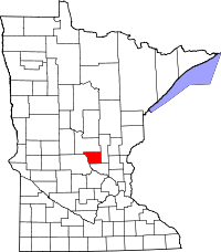 | |
| Townships | ||
| CDP | ||
| Unincorporated communities | ||
| Ghost town | ||
| Footnotes | ‡This populated place also has portions in an adjacent county or counties | |
Municipalities and communities of Sherburne County, Minnesota, United States | ||
|---|---|---|
| Cities |  | |
| Townships | ||
| Unincorporated communities | ||
| Footnotes | ‡This populated place also has portions in an adjacent county or counties | |
Municipalities and communities of Stearns County, Minnesota, United States | ||
|---|---|---|
| Cities |
|  |
| Townships |
| |
| CDP | ||
| Unincorporated communities | ||
| Ghost towns/Neighborhoods | ||
| Footnotes | ‡This populated place also has portions in an adjacent county or counties | |
| Core City |  | ||||
|---|---|---|---|---|---|
| Surrounding communities |
| ||||
| Counties | |||||
‡ indicates that it is partially in the metropolitan area. § indicates a CDP | |||||