Watab, Minnesota
| Watab, Minnesota | |
|---|---|
| Unincorporated community | |
 Watab, Minnesota Location of the community of Watab within Watab Township, Benton County  Watab, Minnesota Watab, Minnesota (the US) | |
| Coordinates: 45°40′35″N 94°10′52″W / 45.67639°N 94.18111°WCoordinates: 45°40′35″N 94°10′52″W / 45.67639°N 94.18111°W | |
| Country | United States |
| State | Minnesota |
| County | Benton |
| Township | Watab Township |
| Elevation | 1,043 ft (318 m) |
| Time zone | UTC-6 (Central (CST)) |
| • Summer (DST) | UTC-5 (CDT) |
| ZIP code | 56379 and 56367 |
| Area code(s) | 320 |
| GNIS feature ID | 654997[1] |
Watab is an unincorporated community in Watab Township, Benton County, Minnesota, United States. The community is located near the junction of River Road and 75th Street. Nearby places include Sauk Rapids, Sartell, and Rice.
| Historical population | |||
|---|---|---|---|
| Census | Pop. | %± | |
| 1860 | 33 | — | |
| 1870 | 22 | −33.3% | |
| U.S. Decennial Census[2] | |||
References
Municipalities and communities of Benton County, Minnesota, United States | ||
|---|---|---|
| Cities | 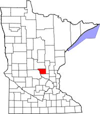 | |
| Townships | ||
| CDP | ||
| Unincorporated communities | ||
| Ghost town | ||
| Footnotes | ‡This populated place also has portions in an adjacent county or counties | |
This article is issued from
Wikipedia.
The text is licensed under Creative Commons - Attribution - Sharealike.
Additional terms may apply for the media files.