Palladaha
| Palladaha | |
|---|---|
| Census Town | |
 Palladaha Location in West Bengal, India  Palladaha Palladaha (India) | |
| Coordinates: 22°56′19″N 88°27′59″E / 22.9387°N 88.4665°ECoordinates: 22°56′19″N 88°27′59″E / 22.9387°N 88.4665°E | |
| Country |
|
| State | West Bengal |
| District | North 24 Parganas |
| Area | |
| • Total | 1.7731 km2 (0.6846 sq mi) |
| Population (2011) | |
| • Total | 5,994 |
| • Density | 3,400/km2 (8,800/sq mi) |
| Languages | |
| • Official | Bengali, English |
| Time zone | UTC+5:30 (IST) |
| Lok Sabha constituency | Barrackpore |
| Vidhan Sabha constituency | Naihati |
| Website |
north24parganas |
Palladaha is a census town under Barrackpore I CD Block (Sub District) in Barrackpore subdivision (also spelled as Barrackpur) in North 24 Parganas district in the Indian state of West Bengal.
Geography
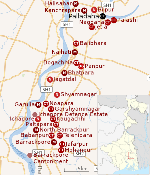 |
| Cities and towns in the northern portion of Barrackpore subdivision in North 24 Parganas district M: municipal city/ town, CT: census town, N: neighbourhood, OG: outgrowth Owing to space constraints in the small map, the actual locations in a larger map may vary slightly |
Location
Palladaha, Nagdaha, Palashi and Srotribati (OG) form an urban cluster east of Kanchrapara. Jetia, Nanna (OG) and Chakla (OG) form another urban cluster south of Kanchrapara.[1]
96% of the population of Barrackpore subdivision (partly presented in the map alongside; all places marked on the map are linked in the full-screen map) lives in urban areas. In 2011, it had a density of population of 10,967 per km2 The subdivision has 16 municipalities and 24 census towns.[2]
For most of the cities/ towns information regarding density of population is available in the Infobox. Population data is not available for neighbourhoods. It is available for the entire municipal area and thereafter ward-wise.
Police station
Naihati police station under Barrackpore Police Commissionerate has jurisdiction over Naihati municipal area and Barrackpore I CD Block, including Barrackpur Cantonment Board.[3][4]
Demographics
As of 2011 India census, Palladaha had a population of 5,994; of this, 3,052 are male, 2,942 female.[5] It has an average literacy rate of 77.01%, higher than the national average of 74.04%.
Infrastructure
As per the District Census Handbook 2011, Palladaha covered an area of 1.7731 km2. Amongst the medical facilities it had were 3 charitable hospital/ nursing homes and 21 medicine shops. Amongst the educational facilities it had were 3 primary schools, and the other nearest schools were available 4 km away at Kanchrapara.[6]
Transport
Palladaha is off Kalyani Expressway.[7]
The railway station at Kanchrapara on the Sealdah-Ranaghat line is located nearby.[8][7]
Healthcare
North 24 Parganas district has been identified as one of the areas where ground water is affected by arsenic contamination.[9]
References
- ↑ "District Census Handbook North Twenty Four Parganas, Census of India 2011, Series 20, Part XII A" (PDF). Map of Barrackpore I CD Block on Page 365. Directorate of Census Operations, West Bengal. Retrieved 21 June 2018.
- ↑ "District Statistical Handbook". North 24 Parganas 2013, Tables 2.1, 2.2, 2.4b. Department of Statistics and Programme Implementation, Government of West Bengal. Retrieved 2 May 2018.
- ↑ "District Statistical Handbook". North 24 Parganas 2013, Tables 2.1, 2.2, 2.4b. Department of Statistics and Programme Implementation, Government of West Bengal. Retrieved 11 June 2018.
- ↑ "Barrackpore Police Commissionerate". List of Police Stations with telephone numbers. West Bengal Police. Retrieved 11 June 2018.
- ↑ "Primary census abstract data". Census of India. Retrieved 23 February 2014. (For census towns, select "urban" radio button, then select state, district and sub-district. A drop down list of towns well appear. Select the town.)
- ↑ "District Census Handbook North Twenty Four Parganas, Census of India 2011, Series 20, Part XII A" (PDF). Section II Town Directory, Pages 781-783 Statement I: Growth History, Pages 799-803; Statement II: Physical Aspects and Location of Towns, Pages 791-794; Statement III: Civic and other Amenities, Pages 795-796; Statement IV: Medical Facilities 2009, Pages 803-805 Section: Educational, Recreational and Cultural Facilities. Directorate of Census Operations V, West Bengal. Retrieved 19 June 2018.
- 1 2 Google maps
- ↑ "31311 Sealdah-Kalyani Simanta Local". Time Table. indiarailinfo. Retrieved 21 June 2018.
- ↑ "Groundwater Arsenic contamination in West Bengal-India (19 years study )". Groundwater arsenic contamination status of North 24-Parganas district, one of the nine arsenic affected districts of West Bengal-India. SOES. Retrieved 2007-08-24.