Bamangachhi
| Bamangachhi | |
|---|---|
| Census Town | |
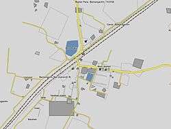 Bamangachhi Town map from satellite view | |
 Bamangachhi Location in West Bengal, India | |
| Coordinates: 22°44′N 88°31′E / 22.74°N 88.51°ECoordinates: 22°44′N 88°31′E / 22.74°N 88.51°E | |
| Country |
|
| State | West Bengal |
| District | North 24 Parganas |
| Area | |
| • Total | 1.3599 km2 (0.5251 sq mi) |
| Population (2011) | |
| • Total | 6,824 |
| • Density | 5,000/km2 (13,000/sq mi) |
| Languages | |
| • Official | Bengali, English |
| Time zone | UTC+5:30 (IST) |
| PIN | 743248 (Bamangachhi Sub Post Office) |
| Telephone code | 033-2542/2552/2562/2584-**** |
| Lok Sabha constituency | Barasat |
| Vidhan Sabha constituency | Barasat |
| Website |
north24parganas |
Bamangachhi is a census town in Barasat I CD Block in Barasat Sadar subdivision of North 24 Parganas district in West Bengal, India. It is situated in Northern portion of West Bengal. It is approximately 26 km north of Kolkata. It is situated at the outskirt of Greater Kolkata and under the authority of KMDA. There are two Sub Post Offices present in this area.
Chhota Jagulia : 743294[1] Bamangachhi : 743706[2]).
Name
The exact reason to be named as Bamangachhi is not known, but according to local lore, it may have been derived the name "bamun para" (literally meaning the neighbourhood of Brahmins), which is an old Brahmin-predominant locality of here.
Geography
Bamangachi, Digha and Kulberia form a cluster of census towns. The entire cluster has a very high density of population. (See the infobox of each census town for density of population).[3]
Duttapukur police station has jurisdiction over Barasat I CD Block.[4]
Transport

Bamangachhi is approximately 26 kilometres (16 mi) from Kolkata, and 4 kilometres (2.5 mi) from North 24 Pargana's district headquarters Barasat. It is well connected by rail and roads with the major destinations in North 24 Parganas and Kolkata. The Bamangachhi Railway Station is a part of Kolkata Suburban Railway under the Sealdah-Bongaon division. The station had been upgraded as the Adarsh Railway Station (model railway station) by the former Railway Minister Mamata Banerjee in the Railway Budget 2011–12 (Upgradation of Bamangachhi Railway Station will provide safe drinking water, pay & use toilets, high-level platforms, better accessibility for the physically challenged among many other facilities at the station.).
Bamangachhi is situated between the two major National Highways, NH-34[5] and NH-35[6](Jessore Road). The National Highway 34 connects Kolkata to Siliguri (in North Bengal) and National Highway 35 connects Kolkata to Jessore, a city in Bangladesh. Bamangachhi is about 16 kilometres (9.9 mi) away from the Netaji Subhas Chandra Bose International Airport, Kolkata and 26 kilometres (16 mi) from Sealdah Railway Station. A major P.W.D. Road, which is known as Bamangachhi-Bamunmura Road has passed across the town and connects Taki Road, NH 35, Bamangachhi Station and NH 34. The other main roads which connects the localities inside Bamangachhi are Station Road, Kashimpur Road, Post Office Road, Nityananda Sarani, B.D.Office Road, Suripukur Road etc.
Climate
The climate of Bamangachhi is tropical, like the rest of the Gangetic West Bengal. The hallmark is the Monsoon, which lasts from early June to mid September. The weather remains dry during the winter (mid November to mid February) and humid during summer.
Infrastructure
As per District Census Handbook 2011, Bamangachhi covered an area of 1.3599 km2. It had 5 primary schools, the nearest middle school was 6 km away at Tentulia, the nearest secondary school and senior secondary schools were 1.5 km away at Mondalganth.[7]
Demographics
As per the 2011 Census of India, Bamangachhi had a total population of 6,824, of which 3,468 (51%) were males and 3,356 (49%) were females. Population below 6 years was 557. The total number of literates in Bamangachhi was 5,554 (88.62% of the population over 6 years).[8]
Culture

As in most parts of West Bengal, the major festivals in Bamangachhi are New Year, Republic & Independence Day, Durgapuja, Diwali, Kalipuja, Laxmipuja, Eid–Uz–Zuha, Christmas.
Education
High School
- Bamangachhi Bholanath High School
- Chhota Jagulia High School
- Bamangachhi Sarada Ramakrishna Missionary School.
- Kalyani Public School, Moina Godi
- Kashimpur High School
- Kashimpur Girl's High School
- Jafrabad High School
Madrasah
- Tentulia Abujafiria Siddiquia Kharejia Madrasah.
Economy
Occupations for most of the people in Bamangachhi Town is service or business. A large number of people lives in Chhota Jagulia Gram Panchayat are involved in agriculture. The people from the villages like Maliakur, Bahera, Sankargachhi, Boropole, Nityananda Sarani, Marait, Murali are mostly involved in agriculture and allied activities. Most of the people of Bamangachhi belong to middle class economy. A large number of people are poor.
Regent Garment and Apparel Park, Murali, Bamangachhi
RDB Industries is setting up a mega garment and apparel park at Murali, Bamangachhi. The entire park is expected to cover 120 acres of land (approximately) beside Jessore Road near Bamangachhi Chowmatha. IIS is designing and managing the execution of the Infrastructure for the Park. The company is investing Rs 4 billion for setting up the park in phased manner. The phase I is under construction with 18 blocks, one Guest House and a Commercial Block. The Phase I will be able to accommodate close to 200 units. The infrastructure consists of state of the art road network with separate storm water & sewer lines. Environment friendly STP, Rain Water Harvesting and Water Treatment minimising discharge. The entire park is expected to be completed by 2018. On completion, the park will be able to house around 1,000 manufacturing units.
See also
- Barasat I CD Block
- Map of Barasat I CD Block on Page 393 of District Census Handbook.[3]
- Ranga Bari – Choto Jagulia Bose family's Jagadatri Puja is 375 years old.
References
- ↑ Chhota Jagulia Postal Code Detail
- ↑ Bamangachhi Postal Code Detail
- 1 2 "District Census Handbook North Twenty Four Parganas, Census of India 2011, Series 20, Part XII A" (PDF). Page 393 -Map of Barasat I CD Block. Directorate of Census Operations, West Bengal. Retrieved 6 May 2018.
- ↑ "North 24 Parganas Dist. Police". Know Your Police Station. District Police. Retrieved 3 June 2018.
- ↑ National Highway 34
- ↑ National Highway 35
- ↑ "District Census Handbook North Twenty Four Parganas, Census of India 2011, Series 20, Part XII A" (PDF). Section II Town Directory, Pages 781-783 Statement I: Growth History, Pages 799-803: Statement IV: Medical Facilities 2009, Pages 803-805 Section: Educational, Recreational and Cultural Facilities. Directorate of Census Operations V, West Bengal. Retrieved 31 May 2018.
- ↑ "C.D. Block Wise Primary Census Abstract Data(PCA)". West Bengal – District-wise CD Blocks. Registrar General and Census Commissioner, India. Retrieved 1 June 2018.
External links
| Wikimedia Commons has media related to Bamangachhi. |
- http://north24parganas.nic.in/
- https://web.archive.org/web/20120429222507/http://censusindia.gov.in/PopulationFinder/Sub_Districts_Master.aspx?state_code=19&district_code=11
Places adjacent to Bamangachhi | |
|---|---|