Siorac-en-Périgord
| Siorac-en-Périgord | ||
|---|---|---|
| Commune | ||
 | ||
| ||
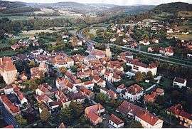
 Siorac-en-Périgord Location within Nouvelle-Aquitaine region  Siorac-en-Périgord | ||
| Coordinates: 44°49′20″N 0°59′15″E / 44.8222°N 0.9875°ECoordinates: 44°49′20″N 0°59′15″E / 44.8222°N 0.9875°E | ||
| Country | France | |
| Region | Nouvelle-Aquitaine | |
| Department | Dordogne | |
| Arrondissement | Sarlat-la-Canéda | |
| Canton | Vallée Dordogne | |
| Intercommunality | Vallée de la Dordogne | |
| Government | ||
| • Mayor (2008–2014) | Jean-Pierre Riehl | |
| Area1 | 11.77 km2 (4.54 sq mi) | |
| Population (2008)2 | 1,005 | |
| • Density | 85/km2 (220/sq mi) | |
| Time zone | UTC+1 (CET) | |
| • Summer (DST) | UTC+2 (CEST) | |
| INSEE/Postal code | 24538 /24170 | |
| Elevation |
46–193 m (151–633 ft) (avg. 60 m or 200 ft) | |
|
1 French Land Register data, which excludes lakes, ponds, glaciers > 1 km2 (0.386 sq mi or 247 acres) and river estuaries. 2 Population without double counting: residents of multiple communes (e.g., students and military personnel) only counted once. | ||

Siorac-en-Périgord is a commune in the Dordogne department in Nouvelle-Aquitaine in southwestern France.
Population
| Historical population | ||
|---|---|---|
| Year | Pop. | ±% |
| 1962 | 807 | — |
| 1968 | 784 | −2.9% |
| 1975 | 793 | +1.1% |
| 1982 | 863 | +8.8% |
| 1990 | 904 | +4.8% |
| 1999 | 890 | −1.5% |
| 2008 | 1,005 | +12.9% |
See also
References
| Wikimedia Commons has media related to Siorac-en-Périgord. |
This article is issued from
Wikipedia.
The text is licensed under Creative Commons - Attribution - Sharealike.
Additional terms may apply for the media files.