Gageac-et-Rouillac
| Gageac-et-Rouillac | |
|---|---|
| Commune | |
 | |
 Gageac-et-Rouillac Location within Nouvelle-Aquitaine region  Gageac-et-Rouillac | |
| Coordinates: 44°48′01″N 0°20′44″E / 44.8003°N 0.3456°ECoordinates: 44°48′01″N 0°20′44″E / 44.8003°N 0.3456°E | |
| Country | France |
| Region | Nouvelle-Aquitaine |
| Department | Dordogne |
| Arrondissement | Bergerac |
| Canton | Sud-Bergeracois |
| Intercommunality | Coteaux de Sigoulès |
| Government | |
| • Mayor (2008–2014) | Philippe Puyponchet |
| Area1 | 13.99 km2 (5.40 sq mi) |
| Population (2008)2 | 465 |
| • Density | 33/km2 (86/sq mi) |
| Time zone | UTC+1 (CET) |
| • Summer (DST) | UTC+2 (CEST) |
| INSEE/Postal code | 24193 /24240 |
| Elevation |
29–146 m (95–479 ft) (avg. 120 m or 390 ft) |
|
1 French Land Register data, which excludes lakes, ponds, glaciers > 1 km2 (0.386 sq mi or 247 acres) and river estuaries. 2 Population without double counting: residents of multiple communes (e.g., students and military personnel) only counted once. | |
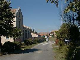
Gageac-et-Rouillac is a commune in the Dordogne department in Nouvelle-Aquitaine in southwestern France.
A scattered village consisting of many small hamlets. Gageac is now the main village with the Mairie whilst Rouillac has the ancient Carthusian monastery, now a private house and stand on a hill with excellent views across the Dordogne valley. In Gageac two stunning chateaux create a sense of history (the one dating back to the 12th century occasionally opens its tower and grounds to the public).The village has some 20 wine producers including Patricia Atkinson who put Gageac et Rouillac on the map with her bestselling books including The Ripening Sun’. Ms Atkinson has now retired. One of the few producers who bottle and sell their wine from the Château is Chateau Lestevenie. It has won many Hachette awards and currently has a top three star rating from Hugh Johnson for its Saussignac wine. Chateau Lestevenie produces the full range of Bergerac wine - red, dry white, rosé, and dry sparkling the famous Saussignac. It offers tastings and vineyard tours. There are some lovely well-marked walks around Gageac et Rouillac, marked with yellow posts and longer ones that connect to adjoining villages marked in green. An informative map of the walks is on the noticeboard outside the Mairie.
Population
| Historical population | ||
|---|---|---|
| Year | Pop. | ±% |
| 1962 | 459 | — |
| 1968 | 451 | −1.7% |
| 1975 | 356 | −21.1% |
| 1982 | 395 | +11.0% |
| 1990 | 440 | +11.4% |
| 1999 | 436 | −0.9% |
| 2008 | 465 | +6.7% |
See also
References
| Wikimedia Commons has media related to Gageac-et-Rouillac. |