Verteillac
| Verteillac | ||
|---|---|---|
| Commune | ||
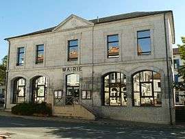 Town hall | ||
| ||
 Verteillac Location within Nouvelle-Aquitaine region  Verteillac | ||
| Coordinates: 45°20′53″N 0°22′01″E / 45.3481°N 0.3669°ECoordinates: 45°20′53″N 0°22′01″E / 45.3481°N 0.3669°E | ||
| Country | France | |
| Region | Nouvelle-Aquitaine | |
| Department | Dordogne | |
| Arrondissement | Périgueux | |
| Canton | Ribérac | |
| Intercommunality | Verteillacois | |
| Government | ||
| • Mayor (2008–2014) | Jean-Pierre Bordier | |
| Area1 | 18.44 km2 (7.12 sq mi) | |
| Population (2008)2 | 644 | |
| • Density | 35/km2 (90/sq mi) | |
| Time zone | UTC+1 (CET) | |
| • Summer (DST) | UTC+2 (CEST) | |
| INSEE/Postal code | 24573 /24320 | |
| Elevation |
79–187 m (259–614 ft) (avg. 135 m or 443 ft) | |
|
1 French Land Register data, which excludes lakes, ponds, glaciers > 1 km2 (0.386 sq mi or 247 acres) and river estuaries. 2 Population without double counting: residents of multiple communes (e.g., students and military personnel) only counted once. | ||
.svg.png)
Verteillac is a commune in the Dordogne department in Nouvelle-Aquitaine in south-western France. In 2014, the feast of Félibrée was held in Verteillac.
International relation
It is twinned with Fontanetto Po in Italy.
Population
| Historical population | ||
|---|---|---|
| Year | Pop. | ±% |
| 1962 | 683 | — |
| 1968 | 655 | −4.1% |
| 1975 | 652 | −0.5% |
| 1982 | 724 | +11.0% |
| 1990 | 706 | −2.5% |
| 1999 | 675 | −4.4% |
| 2008 | 644 | −4.6% |
Sights
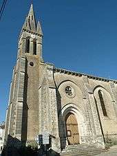
Verteillac church
- Château du Breuil, 16th-17th century
- Château de la Grénerie, 19th century
- Château de la Meyfrenie, 18th-19th century
- Verteillac church
Shopping
Verteillac is a local shopping centre for the nearby villages. It has a general store (Merlaud, which sells everything from lettuce to lawn mowers), butchers, bakers, a brocante, a choice of cafes and restaurants.
Personalities
- Martine Aurillac, députée for Paris, was member of the municipal council of Verteillac from 1971 until 1977.
See also
References
External links
| Wikimedia Commons has media related to Verteillac. |
This article is issued from
Wikipedia.
The text is licensed under Creative Commons - Attribution - Sharealike.
Additional terms may apply for the media files.