Nanteuil-Auriac-de-Bourzac
| Nanteuil-Auriac-de-Bourzac | |
|---|---|
| Commune | |
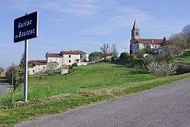 | |
 Nanteuil-Auriac-de-Bourzac Location within Nouvelle-Aquitaine region  Nanteuil-Auriac-de-Bourzac | |
| Coordinates: 45°23′07″N 0°17′29″E / 45.3853°N 0.2914°ECoordinates: 45°23′07″N 0°17′29″E / 45.3853°N 0.2914°E | |
| Country | France |
| Region | Nouvelle-Aquitaine |
| Department | Dordogne |
| Arrondissement | Périgueux |
| Canton | Ribérac |
| Government | |
| • Mayor (2008–2014) | Jean-Paul Poupy |
| Area1 | 20.92 km2 (8.08 sq mi) |
| Population (2008)2 | 281 |
| • Density | 13/km2 (35/sq mi) |
| Time zone | UTC+1 (CET) |
| • Summer (DST) | UTC+2 (CEST) |
| INSEE/Postal code | 24303 /24320 |
| Elevation |
61–180 m (200–591 ft) (avg. 90 m or 300 ft) |
|
1 French Land Register data, which excludes lakes, ponds, glaciers > 1 km2 (0.386 sq mi or 247 acres) and river estuaries. 2 Population without double counting: residents of multiple communes (e.g., students and military personnel) only counted once. | |
Nanteuil-Auriac-de-Bourzac is a commune in the Dordogne department in Nouvelle-Aquitaine in southwestern France.
Geography
The Lizonne forms the commune's western border.
Population
| Historical population | ||
|---|---|---|
| Year | Pop. | ±% |
| 1962 | 482 | — |
| 1968 | 412 | −14.5% |
| 1975 | 384 | −6.8% |
| 1982 | 311 | −19.0% |
| 1990 | 275 | −11.6% |
| 1999 | 252 | −8.4% |
| 2008 | 281 | +11.5% |
See also
References
| Wikimedia Commons has media related to Nanteuil-Auriac-de-Bourzac. |
This article is issued from
Wikipedia.
The text is licensed under Creative Commons - Attribution - Sharealike.
Additional terms may apply for the media files.