Castelnaud-la-Chapelle
| Castelnaud-la-Chapelle | |
|---|---|
| Commune | |
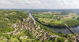 View of Castelnaud-la-Chapelle and its castle | |
 Castelnaud-la-Chapelle Location within Nouvelle-Aquitaine region  Castelnaud-la-Chapelle | |
| Coordinates: 44°48′57″N 1°08′58″E / 44.8158°N 1.1494°ECoordinates: 44°48′57″N 1°08′58″E / 44.8158°N 1.1494°E | |
| Country | France |
| Region | Nouvelle-Aquitaine |
| Department | Dordogne |
| Arrondissement | Sarlat-la-Canéda |
| Canton | Vallée Dordogne |
| Intercommunality | Domme |
| Government | |
| • Mayor (2001–2008) | Germinal Peiro |
| Area1 | 20.88 km2 (8.06 sq mi) |
| Population (2008)2 | 470 |
| • Density | 23/km2 (58/sq mi) |
| Time zone | UTC+1 (CET) |
| • Summer (DST) | UTC+2 (CEST) |
| INSEE/Postal code | 24086 /24250 |
| Elevation |
51–283 m (167–928 ft) (avg. 71 m or 233 ft) |
|
1 French Land Register data, which excludes lakes, ponds, glaciers > 1 km2 (0.386 sq mi or 247 acres) and river estuaries. 2 Population without double counting: residents of multiple communes (e.g., students and military personnel) only counted once. | |
Castelnaud-la-Chapelle is a commune in the Dordogne department in Nouvelle-Aquitaine in southwestern France.
The Château de Castelnaud-la-Chapelle is located in the commune.
Geography
The river Céou flows northward through the western part of the commune, then flows into the Dordogne, which forms all of the commune's northern border.
The village is located above the confluence of the two rivers.
Population
| Historical population | ||
|---|---|---|
| Year | Pop. | ±% |
| 1962 | 497 | — |
| 1968 | 440 | −11.5% |
| 1975 | 380 | −13.6% |
| 1982 | 374 | −1.6% |
| 1990 | 408 | +9.1% |
| 1999 | 426 | +4.4% |
| 2008 | 470 | +10.3% |
See also
References
External links
| Wikimedia Commons has media related to Castelnaud-la-Chapelle. |
| Authority control |
|---|
This article is issued from
Wikipedia.
The text is licensed under Creative Commons - Attribution - Sharealike.
Additional terms may apply for the media files.