Pomport
| Pomport | ||
|---|---|---|
| Commune | ||
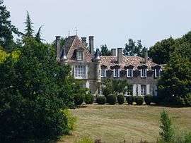 Chateau of Pécany | ||
| ||
 Pomport Location within Nouvelle-Aquitaine region  Pomport | ||
| Coordinates: 44°46′49″N 0°25′07″E / 44.7803°N 0.4186°ECoordinates: 44°46′49″N 0°25′07″E / 44.7803°N 0.4186°E | ||
| Country | France | |
| Region | Nouvelle-Aquitaine | |
| Department | Dordogne | |
| Arrondissement | Bergerac | |
| Canton | Sud-Bergeracois | |
| Intercommunality | Coteaux de Sigoulès | |
| Government | ||
| • Mayor (2008–2014) | Jean-Paul Jammes | |
| Area1 | 19.55 km2 (7.55 sq mi) | |
| Population (2008)2 | 788 | |
| • Density | 40/km2 (100/sq mi) | |
| Time zone | UTC+1 (CET) | |
| • Summer (DST) | UTC+2 (CEST) | |
| INSEE/Postal code | 24331 /24240 | |
| Elevation |
38–171 m (125–561 ft) (avg. 155 m or 509 ft) | |
|
1 French Land Register data, which excludes lakes, ponds, glaciers > 1 km2 (0.386 sq mi or 247 acres) and river estuaries. 2 Population without double counting: residents of multiple communes (e.g., students and military personnel) only counted once. | ||

Pomport is a commune in the Dordogne department in Nouvelle-Aquitaine in southwestern France.
Population
| Historical population | ||
|---|---|---|
| Year | Pop. | ±% |
| 1962 | 868 | — |
| 1968 | 765 | −11.9% |
| 1975 | 673 | −12.0% |
| 1982 | 641 | −4.8% |
| 1990 | 655 | +2.2% |
| 1999 | 706 | +7.8% |
| 2008 | 788 | +11.6% |
See also
References
| Wikimedia Commons has media related to Pomport. |
This article is issued from
Wikipedia.
The text is licensed under Creative Commons - Attribution - Sharealike.
Additional terms may apply for the media files.