Connezac
| Connezac | |
|---|---|
| Commune | |
 | |
 Connezac Location within Nouvelle-Aquitaine region  Connezac | |
| Coordinates: 45°30′40″N 0°31′41″E / 45.5112°N 0.528°ECoordinates: 45°30′40″N 0°31′41″E / 45.5112°N 0.528°E | |
| Country | France |
| Region | Nouvelle-Aquitaine |
| Department | Dordogne |
| Arrondissement | Nontron |
| Canton | Périgord Vert Nontronnais |
| Intercommunality | Périgord Nontronnais |
| Government | |
| • Mayor (2008–2014) | François Waroux |
| Area1 | 5.78 km2 (2.23 sq mi) |
| Population (2008)2 | 83 |
| • Density | 14/km2 (37/sq mi) |
| Time zone | UTC+1 (CET) |
| • Summer (DST) | UTC+2 (CEST) |
| INSEE/Postal code | 24131 /24300 |
| Elevation | 118–209 m (387–686 ft) |
|
1 French Land Register data, which excludes lakes, ponds, glaciers > 1 km2 (0.386 sq mi or 247 acres) and river estuaries. 2 Population without double counting: residents of multiple communes (e.g., students and military personnel) only counted once. | |
Connezac is a commune in the Dordogne department in Nouvelle-Aquitaine in southwestern France. The commune consists of 5 hamlets: Connezac (where the church and the castle are located), Maine Rousset (where the town hall is located), Fontenille, Lafarge and Maine du Bost.
Population
| Historical population | ||
|---|---|---|
| Year | Pop. | ±% |
| 1962 | 101 | — |
| 1968 | 111 | +9.9% |
| 1975 | 103 | −7.2% |
| 1982 | 91 | −11.7% |
| 1990 | 56 | −38.5% |
| 1999 | 82 | +46.4% |
| 2008 | 83 | +1.2% |
Monuments
- Castle of Connezac (16th and 17th century)
- Parish church Saint Martin, former chapel of the castle.
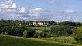 Looking from Connezac to Belussière castle
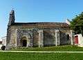 Church
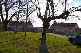
.JPG) Connezac château
Connezac château.JPG) St Martins nave
St Martins nave
See also
References
External links
| Wikimedia Commons has media related to Connezac. |
This article is issued from
Wikipedia.
The text is licensed under Creative Commons - Attribution - Sharealike.
Additional terms may apply for the media files.