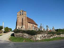
Sainte-Trie
| Sainte-Trie | |
|---|---|
| Commune | |
 | |
 Sainte-Trie Location within Nouvelle-Aquitaine region  Sainte-Trie | |
| Coordinates: 45°18′01″N 1°11′52″E / 45.3003°N 1.1978°ECoordinates: 45°18′01″N 1°11′52″E / 45.3003°N 1.1978°E | |
| Country | France |
| Region | Nouvelle-Aquitaine |
| Department | Dordogne |
| Arrondissement | Sarlat-la-Canéda |
| Canton | Haut-Périgord Noir |
| Government | |
| • Mayor (2008–2014) | Laurent Monteil |
| Area1 | 10.91 km2 (4.21 sq mi) |
| Population (2008)2 | 125 |
| • Density | 11/km2 (30/sq mi) |
| Time zone | UTC+1 (CET) |
| • Summer (DST) | UTC+2 (CEST) |
| INSEE/Postal code | 24507 /24160 |
| Elevation |
167–276 m (548–906 ft) (avg. 247 m or 810 ft) |
|
1 French Land Register data, which excludes lakes, ponds, glaciers > 1 km2 (0.386 sq mi or 247 acres) and river estuaries. 2 Population without double counting: residents of multiple communes (e.g., students and military personnel) only counted once. | |
Sainte-Trie is a commune in the Dordogne department in Nouvelle-Aquitaine in southwestern France.
History
During the creation of the French departments in 1790, the commune first became part of the Corrèze department. It became part of the Dordogne department in 1793.
Population
| Historical population | ||
|---|---|---|
| Year | Pop. | ±% |
| 1962 | 138 | — |
| 1968 | 146 | +5.8% |
| 1975 | 134 | −8.2% |
| 1982 | 136 | +1.5% |
| 1990 | 118 | −13.2% |
| 1999 | 148 | +25.4% |
| 2008 | 125 | −15.5% |
See also
References
External links
| Wikimedia Commons has media related to Sainte-Trie. |
This article is issued from
Wikipedia.
The text is licensed under Creative Commons - Attribution - Sharealike.
Additional terms may apply for the media files.