Urval
| Urval | ||
|---|---|---|
| Commune | ||
 | ||
| ||
 Urval Location within Nouvelle-Aquitaine region  Urval | ||
| Coordinates: 44°48′46″N 0°56′56″E / 44.8128°N 0.9489°ECoordinates: 44°48′46″N 0°56′56″E / 44.8128°N 0.9489°E | ||
| Country | France | |
| Region | Nouvelle-Aquitaine | |
| Department | Dordogne | |
| Arrondissement | Bergerac | |
| Canton | Lalinde | |
| Intercommunality | Cadouin | |
| Government | ||
| • Mayor (2008–2014) | Roland Kupcic | |
| Area1 | 13.38 km2 (5.17 sq mi) | |
| Population (2008)2 | 150 | |
| • Density | 11/km2 (29/sq mi) | |
| Time zone | UTC+1 (CET) | |
| • Summer (DST) | UTC+2 (CEST) | |
| INSEE/Postal code | 24560 /24480 | |
| Elevation |
55–245 m (180–804 ft) (avg. 64 m or 210 ft) | |
|
1 French Land Register data, which excludes lakes, ponds, glaciers > 1 km2 (0.386 sq mi or 247 acres) and river estuaries. 2 Population without double counting: residents of multiple communes (e.g., students and military personnel) only counted once. | ||

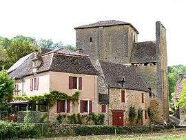
Urval is a commune in the Dordogne department in Nouvelle-Aquitaine in southwestern France. It is situated near the left bank of the river Dordogne, southeast of Le Buisson-de-Cadouin. It was part of the commune of Le Buisson-de-Cadouin between 1974 and 1989.
Sights
- Château de la Bourlie, with French formal garden
Population
| Historical population | ||
|---|---|---|
| Year | Pop. | ±% |
| 1962 | 149 | — |
| 1968 | 159 | +6.7% |
| 1975 | 109 | −31.4% |
| 1982 | 121 | +11.0% |
| 1990 | 123 | +1.7% |
| 1999 | 163 | +32.5% |
| 2008 | 150 | −8.0% |
See also
References
External links
| Wikimedia Commons has media related to Urval. |
This article is issued from
Wikipedia.
The text is licensed under Creative Commons - Attribution - Sharealike.
Additional terms may apply for the media files.