Saint-Cyprien, Dordogne
| Saint-Cyprien | ||
|---|---|---|
| Commune | ||
 | ||
| ||
 Saint-Cyprien Location within Nouvelle-Aquitaine region  Saint-Cyprien | ||
| Coordinates: 44°52′14″N 1°02′40″E / 44.8706°N 1.0444°ECoordinates: 44°52′14″N 1°02′40″E / 44.8706°N 1.0444°E | ||
| Country | France | |
| Region | Nouvelle-Aquitaine | |
| Department | Dordogne | |
| Arrondissement | Sarlat-la-Canéda | |
| Canton | Vallée Dordogne | |
| Intercommunality | Vallée de la Dordogne | |
| Government | ||
| • Mayor (2008–2014) | Pierre Mounet | |
| Area1 | 21.5 km2 (8.3 sq mi) | |
| Population (2008)2 | 1,557 | |
| • Density | 72/km2 (190/sq mi) | |
| Time zone | UTC+1 (CET) | |
| • Summer (DST) | UTC+2 (CEST) | |
| INSEE/Postal code | 24396 /24220 | |
| Elevation |
55–240 m (180–787 ft) (avg. 64 m or 210 ft) | |
|
1 French Land Register data, which excludes lakes, ponds, glaciers > 1 km2 (0.386 sq mi or 247 acres) and river estuaries. 2 Population without double counting: residents of multiple communes (e.g., students and military personnel) only counted once. | ||
.svg.png)
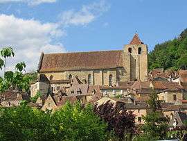
Saint-Cyprien (French for Saint Cyprian) is a commune in the Dordogne department in Nouvelle-Aquitaine in southwestern France.
It serves as the seat of the canton of Vallée Dordogne. It is the most populous commune in the canton.
Population
| Historical population | ||
|---|---|---|
| Year | Pop. | ±% |
| 1962 | 1,617 | — |
| 1968 | 1,649 | +2.0% |
| 1975 | 1,763 | +6.9% |
| 1982 | 1,708 | −3.1% |
| 1990 | 1,593 | −6.7% |
| 1999 | 1,522 | −4.5% |
| 2008 | 1,557 | +2.3% |
Personality
- Joséphine Baker was the godmother of Saint-Cyprien Athletic club "(SCAC) rugby
- Bertrand de Got (1264-1314), Archbishop of Bordeaux, future Pope Clement V, places the monastery of Saint-Cyprien under his jurisdiction.
See also
References
External links
| Wikimedia Commons has media related to Saint-Cyprien (Dordogne). |
This article is issued from
Wikipedia.
The text is licensed under Creative Commons - Attribution - Sharealike.
Additional terms may apply for the media files.