Bouteilles-Saint-Sébastien
| Bouteilles-Saint-Sébastien | |
|---|---|
| Commune | |
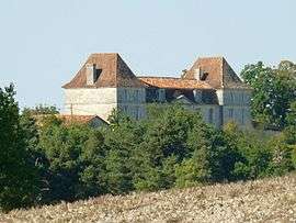 Chateau of Bouteilles | |
 Bouteilles-Saint-Sébastien Location within Nouvelle-Aquitaine region  Bouteilles-Saint-Sébastien | |
| Coordinates: 45°20′45″N 0°18′19″E / 45.3458°N 0.3053°ECoordinates: 45°20′45″N 0°18′19″E / 45.3458°N 0.3053°E | |
| Country | France |
| Region | Nouvelle-Aquitaine |
| Department | Dordogne |
| Arrondissement | Périgueux |
| Canton | Ribérac |
| Intercommunality | Verteillacois |
| Government | |
| • Mayor (2008–2014) | Guy Michel Lamy |
| Area1 | 13.96 km2 (5.39 sq mi) |
| Population (2008)2 | 189 |
| • Density | 14/km2 (35/sq mi) |
| Time zone | UTC+1 (CET) |
| • Summer (DST) | UTC+2 (CEST) |
| INSEE/Postal code | 24062 /24320 |
| Elevation |
58–183 m (190–600 ft) (avg. 100 m or 330 ft) |
|
1 French Land Register data, which excludes lakes, ponds, glaciers > 1 km2 (0.386 sq mi or 247 acres) and river estuaries. 2 Population without double counting: residents of multiple communes (e.g., students and military personnel) only counted once. | |
Bouteilles-Saint-Sébastien is a commune in the Dordogne department in southwestern France.
Geography
The Lizonne forms the commune's southwestern border.
Population
| Historical population | ||
|---|---|---|
| Year | Pop. | ±% |
| 1962 | 313 | — |
| 1968 | 294 | −6.1% |
| 1975 | 250 | −15.0% |
| 1982 | 218 | −12.8% |
| 1990 | 214 | −1.8% |
| 1999 | 191 | −10.7% |
| 2008 | 189 | −1.0% |
See also
References
| Wikimedia Commons has media related to Bouteilles-Saint-Sébastien. |
| Authority control |
|---|
This article is issued from
Wikipedia.
The text is licensed under Creative Commons - Attribution - Sharealike.
Additional terms may apply for the media files.