Saint-Cyr-les-Champagnes
| Saint-Cyr-les-Champagnes | ||
|---|---|---|
| Commune | ||
 | ||
| ||
 Saint-Cyr-les-Champagnes Location within Nouvelle-Aquitaine region  Saint-Cyr-les-Champagnes | ||
| Coordinates: 45°22′47″N 1°17′21″E / 45.3797°N 1.2892°ECoordinates: 45°22′47″N 1°17′21″E / 45.3797°N 1.2892°E | ||
| Country | France | |
| Region | Nouvelle-Aquitaine | |
| Department | Dordogne | |
| Arrondissement | Nontron | |
| Canton | Isle-Loue-Auvézère | |
| Government | ||
| • Mayor (2008–2014) | Alain Pierrefitte | |
| Area1 | 15.81 km2 (6.10 sq mi) | |
| Population (2008)2 | 274 | |
| • Density | 17/km2 (45/sq mi) | |
| Time zone | UTC+1 (CET) | |
| • Summer (DST) | UTC+2 (CEST) | |
| INSEE/Postal code | 24397 /24270 | |
| Elevation |
274–415 m (899–1,362 ft) (avg. 385 m or 1,263 ft) | |
|
1 French Land Register data, which excludes lakes, ponds, glaciers > 1 km2 (0.386 sq mi or 247 acres) and river estuaries. 2 Population without double counting: residents of multiple communes (e.g., students and military personnel) only counted once. | ||

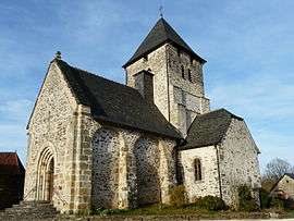
Saint-Cyr-les-Champagnes is a commune in the Dordogne department in Nouvelle-Aquitaine in southwestern France. It has an 11th-12th century romanesque church, dedicated to Saint-Cyr and Sainte-Juliette.
Population
| Historical population | ||
|---|---|---|
| Year | Pop. | ±% |
| 1962 | 395 | — |
| 1968 | 457 | +15.7% |
| 1975 | 380 | −16.8% |
| 1982 | 339 | −10.8% |
| 1990 | 313 | −7.7% |
| 1999 | 295 | −5.8% |
| 2008 | 274 | −7.1% |
See also
References
External links
| Wikimedia Commons has media related to Saint-Cyr-les-Champagnes. |
This article is issued from
Wikipedia.
The text is licensed under Creative Commons - Attribution - Sharealike.
Additional terms may apply for the media files.