Saint-Romain-de-Monpazier
| Saint-Romain-de-Monpazier | |
|---|---|
| Commune | |
 | |
 Saint-Romain-de-Monpazier Location within Nouvelle-Aquitaine region  Saint-Romain-de-Monpazier | |
| Coordinates: 44°43′07″N 0°52′18″E / 44.7186°N 0.8717°ECoordinates: 44°43′07″N 0°52′18″E / 44.7186°N 0.8717°E | |
| Country | France |
| Region | Nouvelle-Aquitaine |
| Department | Dordogne |
| Arrondissement | Bergerac |
| Canton | Lalinde |
| Intercommunality | Monpaziérois |
| Government | |
| • Mayor (2008–2014) | Gérard Chansard |
| Area1 | 7.48 km2 (2.89 sq mi) |
| Population (2008)2 | 78 |
| • Density | 10/km2 (27/sq mi) |
| Time zone | UTC+1 (CET) |
| • Summer (DST) | UTC+2 (CEST) |
| INSEE/Postal code | 24495 /24540 |
| Elevation | 116–227 m (381–745 ft) |
|
1 French Land Register data, which excludes lakes, ponds, glaciers > 1 km2 (0.386 sq mi or 247 acres) and river estuaries. 2 Population without double counting: residents of multiple communes (e.g., students and military personnel) only counted once. | |
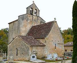
Saint-Romain-de-Monpazier is a commune in the Dordogne department in Nouvelle-Aquitaine in southwestern France.
Population
| Historical population | ||
|---|---|---|
| Year | Pop. | ±% |
| 1962 | 91 | — |
| 1968 | 72 | −20.9% |
| 1975 | 62 | −13.9% |
| 1982 | 67 | +8.1% |
| 1990 | 78 | +16.4% |
| 1999 | 91 | +16.7% |
| 2008 | 78 | −14.3% |
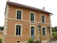
Town hall
See also
References
| Wikimedia Commons has media related to Saint-Romain-de-Monpazier. |
This article is issued from
Wikipedia.
The text is licensed under Creative Commons - Attribution - Sharealike.
Additional terms may apply for the media files.