Meyrals
| Meyrals | |
|---|---|
| Commune | |
 | |
 Meyrals Location within Nouvelle-Aquitaine region  Meyrals | |
| Coordinates: 44°53′59″N 1°03′53″E / 44.8997°N 1.0647°ECoordinates: 44°53′59″N 1°03′53″E / 44.8997°N 1.0647°E | |
| Country | France |
| Region | Nouvelle-Aquitaine |
| Department | Dordogne |
| Arrondissement | Sarlat-la-Canéda |
| Canton | Vallée Dordogne |
| Intercommunality | Vallée de la Dordogne |
| Government | |
| • Mayor (2014-) | Joel Le Corre |
| Area1 | 18.16 km2 (7.01 sq mi) |
| Population (2008)2 | 578 |
| • Density | 32/km2 (82/sq mi) |
| Time zone | UTC+1 (CET) |
| • Summer (DST) | UTC+2 (CEST) |
| INSEE/Postal code | 24268 /24220 |
| Elevation |
90–267 m (295–876 ft) (avg. 150 m or 490 ft) |
|
1 French Land Register data, which excludes lakes, ponds, glaciers > 1 km2 (0.386 sq mi or 247 acres) and river estuaries. 2 Population without double counting: residents of multiple communes (e.g., students and military personnel) only counted once. | |
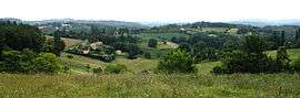
Meyrals is a commune in the Dordogne department in the southwest of France.
Meyrals is in the Périgord and, specifically, the Périgord Noir (Black Périgord), in Aquitaine.
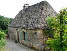
A stone house in Meyrals
Population
| Historical population | ||
|---|---|---|
| Year | Pop. | ±% |
| 1962 | 429 | — |
| 1968 | 434 | +1.2% |
| 1975 | 368 | −15.2% |
| 1982 | 385 | +4.6% |
| 1990 | 417 | +8.3% |
| 1999 | 468 | +12.2% |
| 2008 | 578 | +23.5% |
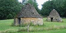
Cabanes (huts made with stones without mortar) in Meyrals
Personalities
- Christophe de Beaumont, (1703–1781), archbishop of Paris, was born in Meyrals.
Events
- Festival des épouvantails (Scarecrows) has been held every summer from 1999 to the present.
- The village of Meyrals was the setting for the film "Périgord noir" (1988), with Roland Giraud.
International relations
Meyral has one sister city:
See also
References
Bibliography
- Jacqueline Jouanel, Histoire de Meyrals, des origines à la Révolution, édition Récéad, 2007
External links
| Wikimedia Commons has media related to Meyrals. |
This article is issued from
Wikipedia.
The text is licensed under Creative Commons - Attribution - Sharealike.
Additional terms may apply for the media files.