Province No. 1
| Province No. 1 प्रदेश न० १ | |
|---|---|
| Province | |
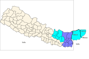
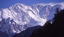
 .jpg) 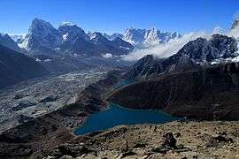 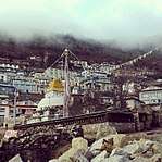 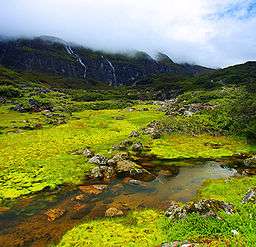 .jpg) 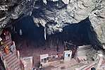 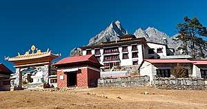 From Top left to right Mt. Everest, Kanchenjunga, Gokyo Lakes, Namche Bazaar, Barun Valley, Ilam, Halesi Mahadev Temple and Tengboche Monastery | |
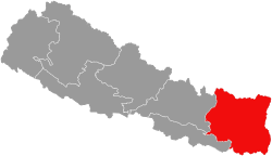 Location of Province No. 1 in Nepal | |
|
Province No. 1 | |
| Coordinates: 26°27′15″N 87°16′47″E / 26.45417°N 87.27972°ECoordinates: 26°27′15″N 87°16′47″E / 26.45417°N 87.27972°E | |
| Country |
|
| Formation | 20 September 2015 |
| Capital city | Biratnagar (Temporary)[1] |
| Largest city | Biratnagar |
| Districts | 14 |
| Government | |
| • Body | Government of Province No.1 |
| • Governor | Prof. Dr. Govinda Bahadur Tumbahang |
| • Chief Minister | Sher Dhan Rai (NCP) |
| • High Court | Biratnagar High Court |
| • Provincial Assembly | Unicameral (93 seats) |
| • Parliamentary constituency | 28 |
| Area | |
| • Total | 25,905 km2 (10,002 sq mi) |
| Area rank | 2nd |
| Highest elevation | 8,848 m (29,029 ft) |
| Lowest elevation | 59 m (194 ft) |
| Population (2011) | |
| • Total | 4,534,943 |
| • Rank | 3rd |
| • Density | 180/km2 (450/sq mi) |
| • Density rank | 4th |
| Demonym(s) | Purbeli but Nepali |
| Time zone | UTC+5:45 (NPT) |
| Geocode | NP-ON |
| Main Official Language | Nepali (43.07%) |
| Other Official Language(s) |
1. Maithili (11.1%) 2. Limbu (7.3%) |
| HDI | 0.553 (medium) |
| Literacy | 73.68% |
| Sex ratio | 91.48 ♂ /100 ♀ (2011) |
| Website |
p1 |

Province No. 1 (proposed names: Koshi or Purbanchal)[2] is one of the seven provinces established by the new constitution of Nepal which was adopted on 20 September 2015.[2]
As per a CDC (Constituency Delimitation Commission) report, Province No. 1 has 28 parliamentary seats and 56 provincial seats under the first-past-the-post voting system.[3] As per a 17 January 2018 cabinet meeting, the city of Biratnagar has been declared the interim capital of Province No. 1. It borders the Tibet Autonomous Region of China to the north, the Indian states of Sikkim and West Bengal to the east, Province No. 3 and Province No. 2 to the west, and Bihar of India to the south.[4][5][6]
According to the 2011 census, there are around 4.5 million people in the province, with a population density of 175.6 per square kilometer.[7]
History
The Kiratas were the aborigines of the north-eastern Himalayas. According to Baburam Acharya, they came to Nepal in about 700 BC and ruled over it. They were short and had robust bodies, broad cheeks, flat noses, thin whiskers, and dark eyes. They were well trained in the art of warfare, and were very skillful archers. They were the ancestors of the present day Kiratas; Limbu, Yakha, Sunuwar, different types of Rais such as yongyang, sampang etc, Kulung, Thulung and Yellung.
Yalamber the king of the Kiratas defeated Bhuvan Singh, the last king of the Ahir dynasty and established Kirat rule in the Kathmandu Valley of Nepal. He extended his kingdom as far as the Teesta river in the east and the Trishuli River in the west.[8]
Later Kirata's Kingdom was divided into many principalities and chiefs ruled in eastern Nepal. Limbuwan, Morang Kingdom belonged to them.
King of Gorkha unified all the kirati kingdoms or Principalities in Nepal from 1771 to 1789.[9]
Previously, before establishment of new constitution on 20 September 2015, the area of Province No. 1 was one of the five Development Regions of Nepal which was named Eastern Development Region. It had 16 districts, 14 existing districts of Province No. 1 and 2 districts Siraha and Saptari of Province No. 2. The Eastern Development Region was divided into 3 zones (subdivisions). The zones were: Mechi Zone, Kosi Zone and Sagarmatha Zone. Mechi included 4 districts, Kosi included 6 and Sagarmatha included 6 districts. The total area of The region was 28,456 km².
Geography
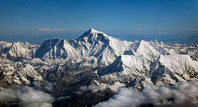
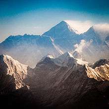
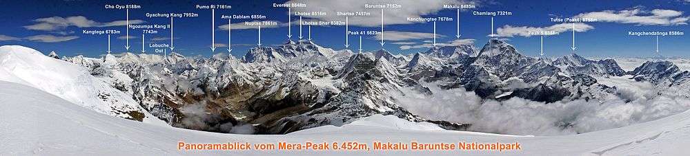
Province No. 1 covers an area of 25,905 km2.[7] The Province has three-fold geographical division: Himalayan in the north, Hilly in the middle and Terai in the southern part of Nepal, varying between an altitude of 60 m and 8,848 m. Terai, extended from east to west, is made up of alluvial soil. To the west of Koshi River, in between Mahabharat Range and Churia Range, there elongates a valley called Inner Terai. Churai Range, Mahabharat Range and other hills of various height, basins, tars and valleys form the hilly region. Some parts of this region are favorable for agriculture but some other parts are not. Himalayan region, in the north, consists of many mountains ranges. Mahalangur, Kumbhakarna, Umvek, Lumba Sumba and Janak being some of them. The highest mountain in the world, Mount Everest (8848 m); and the third highest mountain, Kangchenjunga (8598 m) also lie in this Province.
Nepal's lowest point, Kechana Kawal at 58 m, is located in Jhapa district of this Province. There are many river basins and gentle slopes as well. Chure, Mahabharat, many basins, tars and valleys form the Terai region. Between the Churia and Mahabharat a low land of inner Terai exists. The Koshi river flows through the region with its seven tributaries; Indrawati, Likhu, Tamur, Dudh Kosi, Arun, Tamakoshi and Bhote Koshi (Sunkoshi). Tundra vegetables, coniferous forest, deciduous monsoon forests and sub-tropical evergreen woods are vegetations found here. Sub-tropical, temperate, sub-temperate, and alpine and tundra types of climates are found here.
Province No. 1 also includes the snow fall capped peaks including Mt. Everest, Kangchenjunga, Makalu with Solukhumbu, Sankhuwasabha, and Taplejung districts towards the north, the jungle clad hill tracts of Okhaldhunga, Khotang, Bhojpur, Tehrathum, Ilam and Panchthar in the middle and the alluvial fertile plains of Udayapur, Sunsari, Morang and Jhapa. Province 1 includes places like Haleshi Mahadev Temple, Pathivara Temple and Barahachhetra, which are the famous religious shrines for Hindus.
Climate
Climatic conditions of Nepal vary from one place to another in accordance with their geographical features. Province no. 1 has three geographical folds: The low-land of Terai, the hilly region and the highlands of the Himalayas. The low land altitude is 59 m. Whereas the highest point is 8848 m.
In the north summers are cool and winters severe, while in the south summers are tropical and winters are mild. Climatically, the southern belt of Province, the Terai, experiences warm and humid climate. Eastern Nepal receives approximately 2,500 millimeters of rain annually. Province no. 1 has five seasons: spring, summer, monsoon, autumn and winter.
| Location | August
(°F) |
August
(°C) |
January
(°F) |
January
(°C) |
Annual
Precipitation (mm/in) |
|---|---|---|---|---|---|
| Dharan | 85.1/72.3 | 29.5/22.4 | 68.4/44.4 | 20.2/6.9 | 1416/55.7 |
| Biratnagar | 83.1 | 28.4 | 60.8 | 16 | 1549.8/61 |
| Bhadrapur | 82.2 | 27.9 | 61.2 | 16.2 | 2351.9/92.6 |
| Dhankuta | 76.5 | 24.7 | 54.5 | 12.5 | 1809.5/71.2 |
| Khandbari | 74.8 | 23.8 | 52 | 11.1 | 2040.7/80.3 |
| Ilam | 71.8 | 22.1 | 50.9 | 10.5 | 2551.5/100.5 |
| Bhojpur | 69.1 | 20.6 | 46.8 | 8.2 | 2290.4/90.2 |
| Khumbu Pasang Lhamu | 56.1/38.3 | 13.4/3.5 | 33.8/-0.8 | 1/-18.2 | 645/25.4 |
Mountains
Northern part of Province No. 1 has the highest mountain of the world and there are many peaks that are higher. Here is a list of mountains in Province No. 1.
| Mountain/Peak | metres | feet | Section | Notes |
|---|---|---|---|---|
| Mount Everest | 8,848 | 29,029 | Khumbu Mahalangur | Earth's highest from sea level |
| Kanchenjunga | 8,586 | 28,169 | Northern Kangchenjunga | 3rd highest on Earth |
| Lhotse | 8,516 | 27,940 | Everest Group | 4th highest |
| Makalu | 8,463 | 27,766 | Makalu Mahalangur | 5th highest |
| Cho Oyu | 8,201 | 26,906 | Khumbu Mahalangur | 6th highest |
| Gyachung Kang | 7,952 | 26,089 | Khumbu Mahalangur | between Everest and Cho Oyu |
| Nuptse | 7,861 | 25,791 | Everest Group | 319 metres prominence from Lhotse |
| Jannu | 7,711 | 25,299 | Kumbhakarna Kangchenjunga | |
| Kabru | 7,412 | 24,318 | Singalila Kangchenjunga | |
| Kirat Chuli | 7,365 | 24,163 | Kangchenjunga | |
| Nangpai Gosum | 7,350 | 24,114 | Khumbu Mahalangur | |
| Chamlang | 7,321 | 24,019 | Barun Mahalangur | #79 in the world |
| Pumori | 7,161 | 23,494 | Khumbu Mahalangur | First ascent 1962 |
| Baruntse | 7,129 | 23,389 | Barun Mahalangur | First ascent 1954 |
| Ama Dablam | 6,812 | 22,349 | Barun Mahalangur | "Mother and her necklace" |
| Kangtega | 6,782 | 22,251 | Barun Mahalangur | First ascent 1963 |
| Cho Polu | 6,735 | 22,096 | Barun Mahalangur | First ascent 1999 |
| Lingtren | 6,714 | 22,028 | Khumbu Mahalangur | First ascent 1935 |
| Num Ri | 6,677 | 21,906 | Barun Mahalangur | First ascent 2002 |
| Khumbutse | 6,640 | 21,785 | Khumbu Mahalangur | First mountain west of Everest |
| Thamserku | 6,623 | 21,729 | Barun Mahalangur | First ascent 1964 |
| Pangboche | 6,620 | 21,719 | Kutang Himal | |
| Taboche | 6,542 | 21,463 | Khumbu Mahalangur | First ascent 1974 |
| Mera Peak | 6,476 | 21,247 | Himalayas | Trekking peak |
| Cholatse | 6,440 | 21,129 | Khumbu Mahalangur | Connected to Taboche |
| Kusum Kangguru | 6,367 | 20,889 | Barun Mahalangur | Trekking peak (difficult) |
| Ombigaichan | 6,340 | 20,801 | Barun Mahalangur | |
| Kongde Ri | 6,187 | 20,299 | Barun Mahalangur | Trekking peak (difficult) |
| Imja Tse | 6,160 | 20,210 | Khumbu Mahalangur | Also known as Island Peak. Popular trekking peak. |
| Lobuche | 6,145 | 20,161 | Khumbu Mahalangur | Trekking peak |
| Nirekha | 6,069 | 19,911 | Khumbu Mahalangur | Trekking peak (difficult) |
| Pokalde | 5,806 | 19,049 | Khumbu Mahalangur | Trekking peak (moderate) |
| Mount Khumbila | 5,761 | 18,901 | Mahalangur | Unclimbed |
| Kala Patthar | 5,545 | 18,192 | Khumbu Mah | Popular hiking peak below Pumori |
| Gokyo Ri | 5,357 | 17,575 | Himalayas | Popular hiking peak |
Rivers
There are many rivers in the region which flow towards south from the Himalayas which are tributaries of other large rivers which joins Ganga River (in India). Sapt Koshi or the Koshi is the main river of the region. Seven tributaries join the Koshi so it called Saptkoshi.
The major rivers in the province are:
- Mechi River
- Kankai River
- Koshi River (Sapt Koshi) Below given names are tributaries:
Protected Areas
- Sagarmatha National Park – 1,148 km2 (443 sq mi) (National Park)
- Makalu Barun National Park – 1,500 km2 (580 sq mi) (National Park)
- Koshi Tappu Wildlife Reserve – 175 km2 (68 sq mi) (Wildlife reserves)
- Kanchenjunga Conservation Area – 2,035 km2 (786 sq mi) (Conservation areas)
- Gokyo Lake Complex – 7,770 ha (30.0 sq mi) (Ramsar Sites)
- Kosi Tappu Wildlife Reserve – 17,500 ha (68 sq mi) (Ramsar Sites)
- Mai Pokhari – 90 ha (220 acres) (Ramsar Sites)
Subdivisions
There are total 137 local administrative units in this province, in which there is 1 metropolitan city, 2 sub-metropolitan cities, 46 municipalities and 88 rural municipalities.
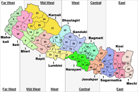
Districts
The province is made up of the 14 following districts:
Municipality
Cities and villages are governed by municipalities in Nepal. A district may have one or more municipalities. Province No. 1 has two types of municipalities.
- Urban Municipality (Urban Municipality has three levels):
- Metropolitan city
- Sub-metropolitan city and
- Municipality
- Rural Municipality (Gaunpalika)
The government of Nepal has set out a minimum criteria to meet city and towns. These criteria include a certain population, infrastructure and revenues.
| Rank | District | Pop. | Rank | District | Pop. | ||||
|---|---|---|---|---|---|---|---|---|---|
 Biratnagar  Itahari |
1 | Biratnagar | Morang | 214,663 | 11 | Bhadrapur | Jhapa | 65,543 |  Dharan  Mechinagar |
| 2 | Itahari | Sunsari | 140,517 | 12 | Shivasataxi | Jhapa | 64,596 | ||
| 3 | Dharan | Sunsari | 137,705 | 13 | Inaruwa | Sunsari | 63,593 | ||
| 4 | Mechinagar | Jhapa | 111,797 | 14 | Pathari Sanischare | Morang | 62,440 | ||
| 5 | Triyuga | Udayapur | 87,557 | 15 | Arjundhara | Jhapa | 60,204 | ||
| 6 | Birtamod | Jhapa | 81,878 | 16 | Suryodaya | Ilam | 56,691 | ||
| 7 | Sundar Haraincha | Morang | 80,518 | 17 | Duhabi | Sunsari | 56,269 | ||
| 8 | Barahachhetra | Sunsari | 77,408 | 18 | Katari | Udayapur | 56,146 | ||
| 9 | Damak | Jhapa | 75,102 | 19 | Ratuwamai | Morang | 55,380 | ||
| 10 | Belbari | Morang | 65,892 | 20 | Urlabari | Morang | 54,696 | ||
Religion in Province No. 1
Demographics
According to Census 2011, there are around 4.5 million people in this state, with a density of 175.6 per square kilometer.
The Khas are the largest ethnicity with the native Rai and Limbu not far behind. Rajbanshi people are also native to Jhapa and Morang.The Rai people live in the hills mostly west of the Arun river in districts like Bhojpur, Khotang and also in Solukhumbu, Udayapur with significant rai population and they are also present Ilam across the Arun. The Limbu people inhabit the hills east of the Arun river in districts like Taplejung, Pachthar, Tehrathum. Both Rais and Limbus also live in Dhankuta, Ilam and Sankhuwasabha.The Sherpa people in the mountains mostly in Solukhumbu.The Maithili people and tharu people who ae a minority live in the terai regions of south Sunsari and Biratnagar and east Morang. All ethinic groups can be found in the Terai districts of Morang, Sunsari, Jhapa and Udayapur these districts are more populated and are denser than the hill districts.Tamang and Magar people are also minorities but who mostly live in Dhankuta, Udayapur and Ilam and throughout the plains.
The majority of people follow Hinduism with Muslim communities especially in Sunsari and Morang, Budhhism is also followed mostly by Tamang, Limbus and other Hill people, Christianity is also a growing religion attracting hundreds of people every year. Animist religion is also followed by some Kirati people.
Notable People
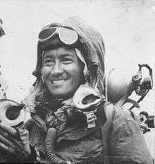
- Tenzing Norgay, the first Mt. Everest climber.
- Sher Dhan Rai, the first Chief minister of Province No. 1
- Jhamak Ghimire, a Nepali writer
- Byakul Maila, lyricist of current Nepalese national anthem
- Narad Muni Thulung Rai,minister of local self-development in the cabinet of Matrika parsad Koirala. He also served as a defence minister and acted as Prime Minister during Matrika P koirala's premiership.He was the first one to initiate and reorganize the freedom movement against the Rana in eastern region od Nepal.
- Ram Prasad Rai, a freedom fighter and a martyr
- Pasang Lhamu Sherpa, Nepal,s first lady climber of Everest
- Krishna Prasad Koirala, Renowned Rana era social activist
- Matrika Prasad Koirala, 18th PM of Nepal
- Bishweshwar Prasad Koirala, 22nd Prime Minister of Nepal and Psychoanalytic writer
- Girija Prasad Koirala, 30th PM of Nepal
- Man Mohan Adhikari, 31st PM of Nepal
- Sushila Karki, First Female Chief Justice of Nepal
- Madan Bhandari, prominent politician against the Panchayat Rule.
- Sitaram Kattel, Nepalese actor and a social worker.
Administration
The first provincial assembly elections in Nepal were held on 26 November and 7 December 2017.
After the results of the recent election in Province No. 1 the biggest party is CPN (UML) which wins 51 seats out of 93 seats and second biggest party is Nepali Congress which wins 21 seats and third biggest party is CPN (Maoist Center) which wins 15 seats in first Provincial Assembly election[11]
There are 56 FPTP and 37 PR seats in Province No. 1
In a meeting on 17 January 2018 government of Nepal finalized the temporary capital of Province No. 1, the meeting also appointed Govinda Subba as the Governor.[12]
Sher Dhan Rai was elected as Chief Minister of Province No. 1 on February 14, 2018.[13] He was a former Minister for Information and Communications. He was appointed as the chief minister, according to Article 168 (1) of the Constitution of Nepal.[13]
Provincial Assembly
The first meeting of the provincial assembly was held on 5 February 2018 in Biratnagar and was chaired by Om Prakash Sarbagi.[14] Pradeep Kumar Bhandari was elected unopposed as the Speaker of the Provincial Assembly on 11 February 2018.[15] Saraswoti Pokharel was also elected unopposed to the post of Deputy Speaker on 15 February 2018.[16]
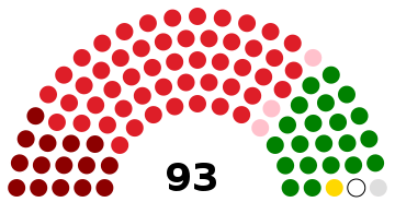 | ||||
| Party | FPTP | PR | Total | |
|---|---|---|---|---|
| NCP | 46 | 20 | 66 | |
| Nepali Congress | 8 | 13 | 21 | |
| Federal Socialist Forum, Nepal | 1 | 2 | 3 | |
| Rastriya Prajatantra Party | 0 | 1 | 1 | |
| Sanghiya Loktantrik Rastriya Manch | 0 | 1 | 1 | |
| Independent | 1 | - | 1 | |
| Total | 56 | 37 | 93 | |
| Source: Election Commission of Nepal | ||||
Cabinet
| Portfolio | Name | Party |
|---|---|---|
| Chief Minister | Sher Dhan Rai[17] | Communist Party of Nepal (Unified Marxist–Leninist) |
| Minister for Internal Affairs and Law | Hikmat Karki[17] | Communist Party of Nepal (Unified Marxist–Leninist) |
| Minister for Social Development | Jivan Ghimire[17] | Communist Party of Nepal (Unified Marxist–Leninist) |
| Minister for Industry, Tourism, Forest and Environment | Jagadish Kusiyat[17] | Communist Party of Nepal (Unified Marxist–Leninist) |
| Minister for Economic Affairs and Planning | Indra Bahadur Aangbo[17] | Communist Party of Nepal (Maoist Centre) |
Economy
Province No. 1 is mainly based on agriculture and tourism. Most of people in Province No. 1 engaged in farming and animal husbandry. Tea, paddy, maize, wheat, potato, millet etc. are main crop in this region.
The three districts Jhapa, Morang and Sunsari of Terai and Udayapur of Inner Terai has fertile land for farming paddy, wheat, sugarcane, maize, millet, jute etc. Farmer of this terai region also produce fruits like mango, litchi and banana.
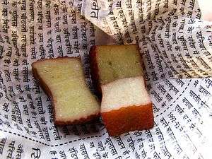
Tea is main crop in hilly region. Ilam and Jhapa are the main region for production of tea although Panchthar, Dhankuta, Bhojpur and Solukhumbu are the new region being involved in tea farming. Bay leaf, cardamom, different fruits and vegetables also grown in this region. Chhurpi a type of cheese also produce from yak in some hilly and mountainous region of Province No. 1.
Northern mountainous region of Province No. 1 has many highest peaks that attracts tourists from around the world.
Biratnagar is economic capital for Province No. 1. There are many factories established in Biratnagar.
Tourism
Eastern Nepal is much more famous than other. It is the one of the tourism place of Nepal. It have beautiful mountains, hills, river, valley, and other famous places. It possesses many more beautiful places which are possibility for tourism development. Every year many of tourists visit this part for different purpose. In this region mountaineering, bungee jumping, rafting, paragliding and other many facilities are provided for tourists.
Trekking goals in eastern Nepal include Makalu Base Camp, an eastern approach to Everest, and the area near Kanchanjangha There is endless variety in this part of the country. Most ethnic groups are represented and many villages, such as Dhankuta, Khandbari and Bhojpur, are large, prosperous and clean. The area has hot, rice-growing districts and also encompasses the cooler tea-growing region of Ilam. The heavily populated Middle Hills are gouged by the mighty Arun River which has cut through at an elevation of less than 400 metres. The Arun is flanked by the major mountain massifs of Kanchenjunga and Makalu. The treks are longer because it requires two weeks to travel from Dharan to the high mountains. Flying to STOL airstrips at Tumlingtar and Taplejung can shorten the time.
Park and Reserve
Hindu Shrines
- Satasi Dham, Arjundhara, (Jhapa)
- Buddha Dham, Maisthan or Mai Pokhari, Larumba, (Ilam)
- Singh Devi, Gupteshwar Mahadev, (Panchthar)
- Pathibhara Devi Temple , (Taplejung)
- Viratkali, (Morang)
- Budha Subba Temple, Barahachhetra , (Sunsari)
- Chhintang Devi, Margsthan, (Dhankuta)
- Singhvahini, (Tehrathum)
- Siddhkali, Manakamna, (Sankhuwasabha)
- Singhkali, Chandisthan, (Bhojpur)
- Chaudandi Devi, (Udayapur)
- Halesi Mahadev Temple, (Khotang)
- Champadevi, (Okhaldhunga)
- Syanboche Gumba, (Solukhumbu)
Location
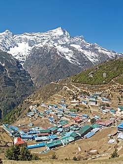
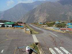
- Lukla Airport, Solukhumbu
- Namche Bazar, Solukhumbu
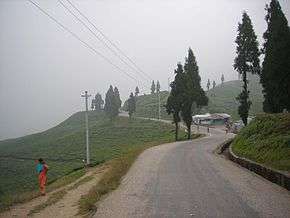
- Kanyam, Ilam
- Bhedetar, Sunsari
- Sukhani Danabari, Ilam
Mountains
- Mt. Everest (Highest mountain of the world)
- Kanchenjunga (3rd highest mountain of the world)
- Lhotse (4th highest mountain of the world)
- Makalu (5th highest mountain of the world)
- Cho Oyu (6th highest mountain of the world)
Hiking Peak
Trekking Peak
Transportation
All provinces of Nepal except Province No. 2 have difficult geographic features. Only three districts out of fourteen of Province No. 1 falls in terai and one district falls in inner terai. Other all districts have difficult features, so road networks are not well developed. There is no train facility. Air services are available.
Roadways
Almost all districts are connected by roads in Province No. 1, although some roads in high altitudes are not paved and conditions of the road worsen during rainy season. In the hills and mountains, the traffic can be very slow due to the difficult terrain and poor road conditions.
Main Highways of Province No. 1 which connects Terai to the high attitude regions.
- Mechi Highway: 2 lanes highway which is 268 km long connects Jhapa to Taplejung. The main destinations along the highway include Prithivinagar, Bhadrapur, Duhagadhi, Budhabare, Kanyam, and Phikkal.
- Koshi Highway: 2 lanes of road and 159 km long, starts from Biratnagar and connects Myanglung with it. Itahari, Dharan, Dhankuta, Bhedetar, Hile etc. are the destinations along with highway.
- Sagarmatha Highway: 2 lanes, 265 km long highway starts from Kadmaha of Province No. 2 and connects Solukhumbu with it. Gaighat, Saune etc. are the destinations along with highway.
Airways
Many domestic airports and air services are available in the region.
Airports in Provinc No. 1:
- Bhojpur Airport (Bhojpur)
- Biratnagar Airport (Biratnagar)
- Kangel Danda Airport (Kangel, Solukhumbu)
- Man Maya Airport (Khanidanda, Khotang)
- Thamkharka Airport (Khotang Bazar)
- Lamidanda Airport (Lamidanda, Khotang)
- Tenzing-Hillary Airport (Lukla, Solukhumbu)
- Phaplu Airport (Phaplu, Solukhumbu)
- Rumjatar Airport (Rumjatar, Okhladhunga)
- Syangboche Airport (Syangboche, Solukhumbu)
- Taplejung Airport (Taplejung)
- Tumlingtar Airport (Tumlingtar, Sankhuwasabha)
- Bhadrapur Airport (Bhadrapur, Jhapa)
See also
References
- ↑ "Winners root for Biratnagar as provincial capital". thehimalayantimes.com. 18 January 2018. Retrieved 18 January 2018.
- 1 2 "Nepal Provinces". statoids.com. Retrieved 2016-03-21.
- ↑ "EDITORIAL: Important step". The Himalayan Times. 1 September 2017. Retrieved 5 September 2017.
- ↑ "Biratnagar celebrates its status of provincial capital". thehimalayantimes.com. 19 January 2018. Retrieved 19 January 2018.
- ↑ "Locals intensify protest in Dhankuta after Biratnagar named as provincial HQ". kathmandupost.ekantipur.com. 19 January 2018. Retrieved 19 January 2018.
- ↑ "Nepal government announces Provincial Capitals and Chiefs". ddinews.gov.in. 17 January 2018. Retrieved 19 January 2018.
- 1 2 "Province 1: Call for opportunities in land of great promise". Kantipur Publications Pvt. Ltd. 12 August 2015. Retrieved 5 September 2017.
- ↑ "Far east kingdom (South Asia)". historyfiles.co.uk. Retrieved 4 September 2017.
- ↑ "limbuwan gorkha war". Retrieved 5 September 2017.
... The Limbuwan Gorkha War was a series of battles fought between the King of Gorkhas and the rulers of various principalities of Limbuwan from 1771 to 1774. The war came to an end in 1774 with the Limbuwan Gorkha treaty which recognised Limbu peoples'right to Kipat land in Limbuwan and full autonomy. Thus the Limbuwan Gorkha War came to an end in 1774 with all the principalities of Limbuwan joining the Gorkha kingdom ...'
- ↑ "Nepal Travel Weather Averages (Weatherbase)". Weatherbase. Retrieved 2018-04-28.
- ↑ "Province No. 1". kathmandupost.ekantipur.com. Retrieved 12 December 2017.
- ↑ "Government finalises provinces' governors and temporary headquarters". nepalekhabar.com. 17 January 2018. Retrieved 19 January 2018.
- 1 2 "Sherdhan Rai elected CM of Province 1". kathmandupost.ekantipur.com. 14 February 2018. Retrieved 15 February 2018.
- ↑ "First Province Assembly meeting of Province 1 today". Retrieved 2018-03-23.
- ↑ "Pradeep Bhandari named Province 1 speaker". Retrieved 2018-03-23.
- ↑ "Province 1 endorses Saraswoti Pokhrel's candidacy for deputy speaker". Kathmandu Tribune. 15 February 2018. Retrieved 23 March 2018.
- 1 2 3 4 5 "Rai sworn in as Province 1 chief minister". The Himalayan Times. 2018-02-16. Retrieved 2018-03-23.
Places adjacent to Province No. 1 | ||||||||||
|---|---|---|---|---|---|---|---|---|---|---|
| ||||||||||
 | ||