Katari
| Katari कटारी नगरपालिका | |
|---|---|
| Municipality | |
 Katari Location in Province No. 1  Katari Katari (Nepal) | |
| Coordinates: 26°57′N 86°22′E / 26.95°N 86.37°ECoordinates: 26°57′N 86°22′E / 26.95°N 86.37°E | |
| Country | Nepal |
| Province | Province No. 1 |
| District | Udayapur |
| No. of wards | 14 |
| Established | 2014 |
| Incorporated (VDC) | Tribeni, Katari, Risku, Lekhani, Hardeni, Limpatar, Sorungchabise, Sirise |
| Incorporated (date) | 2017 |
| Government | |
| • Type | Mayor–council |
| • Body | Katari Municipality |
| • Mayor | Mr. Gyanendra Shrestha (NCP) |
| • Deputy Mayor | Mrs. Bhim Kumari Raut (NCP) |
| • MP & Constituency |
Udayapur 2 Suresh Kumar Rai (NCP) |
| • MLA & Constituency |
Udayapur 2(B) Kala Ghale (NCP) |
| Area | |
| • Total | 424.89 km2 (164.05 sq mi) |
| Area rank | 3rd in Province |
| Population (2011) | |
| • Total | 56,146 |
| Time zone | UTC+5:45 (NPT) |
| Website |
kataarimun |
Katari is a Municipality in Udayapur District in the Province No. 1 of south-eastern Nepal.It lies by the Tawa river (formed by unification of original Tawa river and Baidhyanath river) having the bridge of length 123.5m. This was established by merging two existing village development committees i.e. Triveni and Katari on 18 May 2014.[1][2] At the time of the 1991 Nepal census it had a population of 7230 people living in 1410 individual households.[3]
See also
References
- ↑ 72 new municipalities announced Archived 2014-06-18 at the Wayback Machine. My Republica
- ↑ Govt announces 72 new municipalities The Kathmandu Post
- ↑ "Nepal Census 2001". Nepal's Village Development Committees. Digital Himalaya. Archived from the original on October 12, 2008. Retrieved 13 November 2008.
External links
Headquarter: Triyuga | ||
| Municipality | 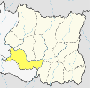 | |
| Rural Municipality | ||
This article is issued from
Wikipedia.
The text is licensed under Creative Commons - Attribution - Sharealike.
Additional terms may apply for the media files.