Kechana Kawal
| Kechana Kawal केचना कवल | |
|---|---|
|
The lowest point of Nepal The lowest point of Province No. 1 | |
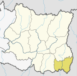
 Kechana Kawal Location in Province No. 1  Kechana Kawal Kechana Kawal (Nepal) | |
| Coordinates: 26°22′23″N 88°01′22″E / 26.372926°N 88.022659°ECoordinates: 26°22′23″N 88°01′22″E / 26.372926°N 88.022659°E | |
| Country |
|
| Province | Province No. 1 |
| District | Jhapa District |
| Municipality | Kachankawal Rural Municipality |
| Elevation | 64 m (210 ft) |
| Time zone | UTC+5:45 (Nepal Time) |
Kechana Kawal (Nepali: केचना कवल) is a place located in Kachankawal Rural Municipality (previously, Kechana VDC) of Province No. 1 of Nepal. At an elevation of 64 metres (210 ft) above sea level, it is one of the lowest points of Nepal.[1] On the other hand, Mount Everest, the highest point in Nepal and on Earth, is located in Khumjung of Solukhumbu District in the same province.[2] [3]
See also
References
- ↑ Dhital, Megh Raj (2015-02-11). Geology of the Nepal Himalaya: Regional Perspective of the Classic Collided Orogen. Springer. ISBN 9783319024967.
- ↑ "Brief Introduction". Jhapa Municipality. Retrieved 3 November 2017.
- ↑ "Kechana Kawal". placemap.net. Retrieved 3 November 2017.
This article is issued from
Wikipedia.
The text is licensed under Creative Commons - Attribution - Sharealike.
Additional terms may apply for the media files.