Lukla
| Lukla | |
|---|---|
| town | |
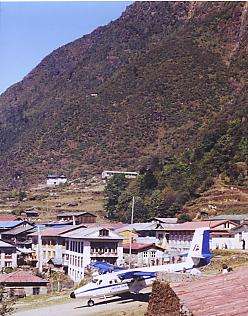 Looking across the township of Lukla, with the air strip of Lukla Airport in the foreground | |
 Lukla Location in Nepal  Lukla Lukla (Nepal) | |
| Coordinates: 27°41′20″N 86°43′50″E / 27.68889°N 86.73056°ECoordinates: 27°41′20″N 86°43′50″E / 27.68889°N 86.73056°E | |
| Country |
|
| Province | Province No. 1 |
| District | Solukhumbu District |
| Rural municipality | Khumbu Pasanglhamu |
| Government | |
| • Type | Ward division |
| Elevation | 2,860 m (9,380 ft) |
| Time zone | UTC+5:45 (Nepal Time) |
| Postal code | 56010 |
| Area code(s) | 038 |
Lukla (Nepali: लुक्ला) is a small town in the Khumbu Pasanglhamu rural municipality of the Solukhumbu District in the Province No. 1 of north-eastern Nepal. Situated at 2,860 metres (9,383 ft), it is a popular place for visitors to the Himalayas near Mount Everest to arrive. Although Lukla means place with many goats and sheep, few are found in the area these days.
Lukla contains a small airport servicing the region, and a variety of shops and lodges catering to tourists and trekkers, providing western-style meals and trail supplies.
From Lukla, travellers will take two days to reach the village Namche Bazaar, an altitude acclimatization stop for those continuing on.[1]
In August 2014, the Nepalese government announced plans to open the first tarmac road from Kathmandu to Lukla.[2]
Airport
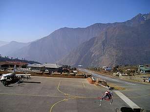
Lukla is served by the Tenzing-Hillary Airport. Weather permitting, twin-engined Dornier Do 228s and de Havilland Canada Twin Otters make frequent daylight flights between Lukla and Kathmandu. Lukla Airport has a very short and steep airstrip, often compounded by hazardous weather, resulting in several fatal accidents. It has been called the most dangerous airport in the world.[4][5]
Climate
| Climate data for Lukla, Nepal | |||||||||||||
|---|---|---|---|---|---|---|---|---|---|---|---|---|---|
| Month | Jan | Feb | Mar | Apr | May | Jun | Jul | Aug | Sep | Oct | Nov | Dec | Year |
| Average high °C (°F) | 1.0 (33.8) |
1.9 (35.4) |
4.7 (40.5) |
8.2 (46.8) |
11.6 (52.9) |
14.7 (58.5) |
14.4 (57.9) |
13.4 (56.1) |
12.7 (54.9) |
8.9 (48) |
5.5 (41.9) |
3.3 (37.9) |
8.4 (47) |
| Daily mean °C (°F) | −5.9 (21.4) |
−4.8 (23.4) |
−1.6 (29.1) |
2.2 (36) |
5.6 (42.1) |
9.2 (48.6) |
10.3 (50.5) |
9.8 (49.6) |
8.0 (46.4) |
3.1 (37.6) |
−1.2 (29.8) |
−3.8 (25.2) |
2.6 (36.6) |
| Average low °C (°F) | −18.2 (−0.8) |
−16.3 (2.7) |
−12.1 (10.2) |
−7.4 (18.7) |
−3.4 (25.9) |
1.6 (34.9) |
3.9 (39) |
3.5 (38.3) |
0.8 (33.4) |
−6.5 (20.3) |
−12.5 (9.5) |
−16.3 (2.7) |
−6.9 (19.6) |
| Average precipitation mm (inches) | 10.8 (0.425) |
18.0 (0.709) |
21.6 (0.85) |
28.3 (1.114) |
34.4 (1.354) |
96.1 (3.783) |
153.8 (6.055) |
144.7 (5.697) |
80.7 (3.177) |
37.4 (1.472) |
6.2 (0.244) |
13.0 (0.512) |
645 (25.392) |
| Average precipitation days | 2.6 | 2.7 | 3.6 | 5.0 | 9.5 | 16.1 | 22 | 21.8 | 15.0 | 4.5 | 1.9 | 1.4 | 106.1 |
| Source: weatherbase.com[6] | |||||||||||||
See also
References
- ↑ Muza, SR; Fulco, CS; Cymerman, A (2004). "Altitude Acclimatization Guide". US Army Research Inst. of Environmental Medicine Thermal and Mountain Medicine Division Technical Report (USARIEM–TN–04–05). Retrieved 2009-03-05.
- ↑ "A new highway... up to Everest: First tarmac road to town known as gateway to the mountain set to be built". Retrieved 2014-08-14.
- ↑ "Which Everest Base Camp is Best:Tibet or Nepal?".
- ↑ "World's Most Dangerous Airports". Retrieved 2011-03-25.
- ↑ "Which Everest Base Camp is Best:Tibet or Nepal?".
- ↑ http://www.weatherbase.com/weather/weather.php3?s=603638
External links
| Wikimedia Commons has media related to Lukla. |
- Hiking Everest from Lukla, GoNOMAD feature article
- "The Lukla Airport Experience" article and photos on GearJunkie.com.
- "Most Dangerous airport in the world" Lukla Airport video
- Lukla Travel Guide
- "Lukla Flight Scheduled"