Morang District
| Morang District मोरङ जिल्ला | |
|---|---|
| District | |
 | |
| Country | Nepal |
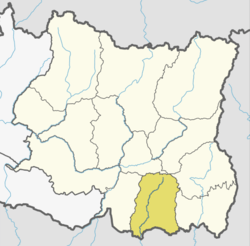
| Province | Province No. 1 |
| Established | 7th century circa |
| Admin HQ. | Biratnagar |
| Government | |
| • Type | Coordination committee |
| • Body | DCC, Morang |
| • Head | Mr. Naresh Prasad Pokhrel |
| • Deputy-Head | Mr. Prakash Kumar Shah |
| • Parliamentary constituencies | 6 |
| • Provincial constituencies | 12 |
| Area | |
| • Total | 1,855 km2 (716 sq mi) |
| Population (2011[1]) | |
| • Total | 965,370 |
| • Density | 520/km2 (1,300/sq mi) |
| Time zone | UTC+5:45 (NPT) |
| Main Language(s) | Nepali, Maithili, Tharu, Rajbanshi, Limbu |
| Website |
www |
Morang District (Nepali: मोरङ जिल्ला ![]()
Morang district along with Sunsari district and parts of Jhapa district were once under the old Morang Kingdom of Limbuwan, established by Limbu King Mawrong Hang. Later descendents of Limbu family converted into Hinduism and the names of Haang (Kings) of Limbuwan were Hinduised. One of the most famous Limbu King of Morang, Maharaj Sri Sri Bijay Narayan Raya Ing, a Hinduised Limbu King named the capital of Morang Kingdom as Bijaypur (present day Sunsari district) and ruled from there. Bijaypur remained capital and Budhhi Karna Raya Khewang was last Limbu King of Morang till annexation by King of Gorkha Prithvi Narayan Shah through Abhiman Singh Basnet, Parath Bhandari, Bali Baniya and Kirti Singh Khawas.
Geography and climate
| Climate Zone[2] | Elevation Range | % of Area |
|---|---|---|
| Lower Tropical | below 300 meters (1,000 ft) | 80.9% |
| Upper Tropical | 300 to 1,000 meters 1,000 to 3,300 ft. |
11.5% |
| Subtropical | 1,000 to 2,000 meters 3,300 to 6,600 ft. |
7.4% |
| Temperate | 2,000 to 3,000 meters 6,400 to 9,800 ft. |
0.2% |
Morang lies in the southern Terai, or plains, of Eastern Nepal. Most of the land is taken up by rice and jute cultivation, though areas of sal forest remain along the northern part of the district where the plains meet the hills.
Economy
Most of the district is rural, though it is also home to Biratnagar, the second largest city in Nepal after Kathmandu, capital city of the nation. It is the industrial capital of Nepal. Morang has the highest numbers of industries and factories, multinational brands too. Other emerging towns include Urlabari, Biratchowk, Belbari, Pathari and Rangeli. It also boasts the largest industrial area in the whole country, expanding from Rani Mills Area to Duhabi River. Biratnagar Jute Mills, Arihant and Dhanawat Matches are among the nation's oldest industries.
Education
Morang district is home to the historic Morang Campus (Mahendra Morang Adarsh Multiple Campus, Biratnagar), Sukuna Multiple Campus(sunderHaraicha Municipality), Urlabari Multiple Campus, Pathari Multiple Campus, and several other institutions of higher learning. Sukuna Multiple Campus is one of the biggest in the Eastern Development Region and reputed colleges with around 5000 students situatd at sunderharaincha of Morang district. The opening of Purbanchal University in Biratnagar, which offers graduate level courses in many disciplines of Science, Arts and Liberal Sciences, is certain to make the place a college town as it attracts college graduates from most of the part of the nation. The University is committed to achieve academic excellence through research, teaching and practical studies in specific areas that contribute to the social, economic and sustainable development of the country. At present, the University has broadly identified Industry-Technology, Agriculture-Forestry, Environment- Rural-Cultural Subsistence and Sustainable Development as specific areas of “Academic Excellence”. It has affiliated private in all the parts of Nepal.
Janasewa Higher Secondary School situated at Bayarban VDC is one of the biggest schools of this district. It was established in 2025 B.S. Mr Tularam Gurung, former Principal, spent his fertile youth to bring the school in today's situation. There are many other popular and old government schools such as Jante higher secondary school, Jante, Radhika Ma Vi, Urlabari, Adarsha higher secondary school, Biratnagar, Public H. Sec. School, Rangeli, Shree Kali H. Sec. School, Kashijan.
History
The name Morang is derived from the name of the Limbu King Mawrong Mung Hang, who established the Morang Kingdom in the beginning of seventh century. His capital and fort was at Rongli, present day Rangeli. Morang was then annexed to greater Limbuwan by King Uba Hang in 849 CE and ruled until 1584 CE when Limbu King Sanïgla Ing made Morang independent and ruled from Varatappa situated east of modern Bijaypur. The Ing Dynasty, the Sen dynasty and then the Khebang dynasty ruled Morang until 1774 CE. The Morang name fell from use after the annexation of all the Kingdoms of Limbuwan, including Morang, by King Prithivi Narayan Shah of Gorkha. The last King of Morang was Budhhi Karna Raya Khewang, who ruled from Bijaypur near Dharan.
The name Morang came into use again after the shah kings divided the country into administrative districts and Morang was named after the old Morang Kingdom.
A large amount of the forest was cleared in the last century, and in the process, many settlers migrated to the district from the hills and India. The Morang plains are one of the most culturally diverse regions in Nepal.
Politics
Morang has been a hotbed of political activity throughout Nepal's recent history producing political stalwarts such as Matrika Prasad Koirala, BP Koirala, Madan Bhandari, Girija Prasad Koirala, Man Mohan Adhikari, Sushil Koirala, Bharat Mohan Adhikari as well as the present time leaders like Shekhar Koirala, Upendra Yadav, etc.
The district currently sends nine members to the national legislature.
Administrative divisions
Municipalities
- Biratnagar Metropolitan City
- SundarHaraicha_Municipality
- Belbari Municipality
- Pathari-Sanischare Municipality
- Urlabari Municipality
- Rangeli Municipality
- Letang Bhogateni Municipality
- Ratuwamai Municipality
- Sunbarshi Municipality
Rural Municipalities
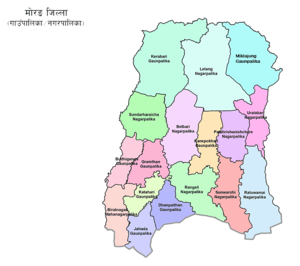
- Kerabari Rural Municipality
- Miklajung Rural Municipality
- Kanepokhari Rural Municipality
- Budiganga Rural Municipality
- Gramthan Rural Municipality
- Katahari Rural Municipality
- Dhampalthan Rural Municipality
- Jahada Rural Municipality
References
- ↑ Household and population by districts, Central Bureau of Statistics (CBS) Nepal Archived 2013-07-31 at the Wayback Machine.
- ↑ The Map of Potential Vegetation of Nepal - a forestry/agroecological/biodiversity classification system (PDF), Forest & Landscape Development and Environment Series 2-2005 and CFC-TIS Document Series No.110., 2005, ISBN 87-7903-210-9, retrieved Nov 22, 2013
Further reading
- Shaha, Rishikesh (1992). Ancient and Medieval Nepal. Manohar Publications, New Delhi. ISBN 978-81-85425-69-6.
- Shreshta, S.H (2005). Nepal in Maps. Kathmandu: Educational Publishing House. p. 129.
- Shreshta, Vinod Prasad (2007). A Concise Geography of Nepal. Kathmandu: Mandal Publications. p. 126. ISBN 978-99946-55-04-5.
- Woodhatch, Tom (1999). Nepal handbook. The Royal Palace. Footprint Travel Guides. p. 194. ISBN 978-1-900949-44-6. Retrieved 2009-12-17.
External links
- "Districts of Nepal". Statoids.
| Wikimedia Commons has media related to Morang District. |
