Harinagara
| Harinagara हरिनगरा गाउँपालिका | |
|---|---|
| Rural Municipality | |
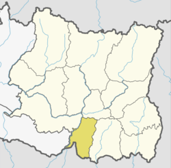
 Harinagara Location in Province No. 1  Harinagara Harinagara (Nepal) | |
| Coordinates: 26°30′12″N 87°07′19″E / 26.503297°N 87.121947°ECoordinates: 26°30′12″N 87°07′19″E / 26.503297°N 87.121947°E | |
| Province | Province No. 1 |
| District | Sunsari |
| Wards | 7 |
| Established | 10 March 2017 |
| Government | |
| • Type | Rural Council |
| • Chairperson | Mr. Gafar Ansari |
| • Vice-chairperson | Mrs. Rimjhim Kumari Bhagat |
| Area | |
| • Total | 52.29 km2 (20.19 sq mi) |
| Population (2011) | |
| • Total | 40,846 |
| • Density | 780/km2 (2,000/sq mi) |
| Time zone | UTC+5:45 (Nepal Standard Time) |
| Headquarter | Harinagara |
| Website | official website |
Harinagara (Nepali: हरिनगरा गाउँपालिका) is a rural municipality (gaunpalika) out of six rural municipality located in Sunsari District of Province No. 1 of Nepal. There are a total of 12 municipalities in Sunsari in which 6 are urban and 6 are rural.
According to Ministry of Federal Affairs and Local Developme Harinagara has an area of 52.29 square kilometres (20.19 sq mi) and the total population of the municipality is 40846 as of Census of Nepal 2011. [1] [2]
Ramnagar Bhutaha, Gautampur, Harinagara, Basantapur and Ghuski which previously were all separate Village development committee merged to form this new local level body. Fulfilling the requirement of the new Constitution of Nepal 2015, Ministry of Federal Affairs and Local Development replaced all old VDCs and Municipalities into 753 new local level body (Municipality).[1]
The rural municipality is divided into total 7 wards and the headquarter of this newly formed rural municipality is situated in Harinagara VDC.[1]
References
- 1 2 3 "स्थानीय तहहरुको विवरण". www.mofald.gov.np/en. MoFALD. Retrieved 21 April 2018.
- ↑ "CITY POPULATION – statistics, maps & charts". www.citypopulation.de. 8 October 2017. Retrieved 21 April 2018.