Bhedetar
| Bhedetar भेडेटार | |
|---|---|
|
VDC Hill station | |
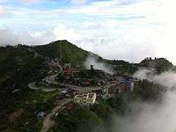 Bhedetar aerial view | |
 Bhedetar Location in Nepal | |
| Coordinates: 26°53′0″N 87°20′0″E / 26.88333°N 87.33333°ECoordinates: 26°53′0″N 87°20′0″E / 26.88333°N 87.33333°E | |
| Country |
|
| Zone | Kosi Zone |
| District | Dhankuta District |
| Elevation | 1,420 m (4,660 ft) |
| Population (2011) | |
| • Total | 2,977 |
| Time zone | UTC+5:45 (NST) |
| Postal code | 56804 |
| Area code(s) | 026 |
| Nearest city | Dharan |
Bhedetar (translation: Sheep's Butte) is a village development committee in Dhankuta District in the Koshi Zone of eastern Nepal. At the time of the 1991 Nepal census it had a population of 2643 people living in 513 individual households.[1] It is 1,420 meters high from the sea level. It is actually the border line of Sunsari and Dhankuta district.
Attractions
Bhedetar is a developing tourist spot. It is a small hill station just 16 kilometers away from Dharan Sub-metropolis. It is famous for its unpredictable weather - a moment it hides itself in the blanket of thick fog and another moment it reveals itself as the crown of urban Dharan.
Nepal Television has a High Power Transmitter Station at Bhedetar which broadcasts different Channels of Nepal Television. Transmissions are not only received by the Bhedetar but also neighbouring places.
References
- ↑ "Nepal Census 2001". Nepal's Village Development Committees. Digital Himalaya. Archived from the original on 12 October 2008. Retrieved 24 November 2008.
Headquarter: Dhankuta | ||
| Rural Municipalities | 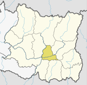 | |
| Municipalities | ||