Kerabari Gaunpalika
| Kerabari Gaupalika | |
|---|---|
| Gaupalika | |
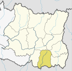
 Kerabari Gaupalika Kerabari Gaupalika in the map | |
| Coordinates: 26°44′N 87°25′E / 26.74°N 87.41°ECoordinates: 26°44′N 87°25′E / 26.74°N 87.41°E | |
| country | Nepal |
| Province | Province No. 1 |
| District | Morang District |
| established | 27 Falgun 2073 |
| Government | |
| • Chairperson | Mr. Rohit Bahadur Karki |
| • Vice-chairperson | Mrs. Shanti Kumari Limbu Bhujel |
| Area | |
| • Total | 219.83 km2 (84.88 sq mi) |
| Population (2017)[1] | |
| • Total | 30,431 |
| • Density | 140/km2 (360/sq mi) |
| Time zone | UTC+5:45 (Nepal Standard Time) |
| Area code(s) | +977-021 |
| Office | Present Kerabari VDC Office |
| Website | Official Website |
Kerabari Gaupalika (Nepali: केराबारी गाउँपालिका) is a Gaupalika (rural municipality) located at Morang district.[1][2] Letang Bhogateni Municipality (Ward no.1), Kerabari, Yangshila, Singhadevi and Patigaun VDCs were incorporated into Kerabari Gaupalika. This rural municipality has an area of 219.83 sq. km. The population as of 2017 is 30,431. The current VDC Office of Kerabari is the office of this Gaupalika.[2]
References
- 1 2 "List of Urban and Rural Municipalities of Nepal" (PDF). Ministry of Federal Affairs and Local Development. Retrieved 2017-06-02.
- 1 2 "हेर्नुहोस्, तपाईं कुन गाउँपालिका वा नगरपालिकामा पर्नुभयो?". setopati. Retrieved 15 June 2017.
This article is issued from
Wikipedia.
The text is licensed under Creative Commons - Attribution - Sharealike.
Additional terms may apply for the media files.