Sirijangha
| Sirijangha सिरीजङ्घा | |
|---|---|
| Rural Municipality in Nepal | |
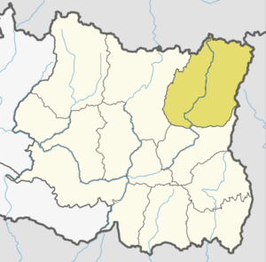
 Sirijangha Location in Nepal | |
| Coordinates: 27°24′35.96″N 87°54′35.94″E / 27.4099889°N 87.9099833°ECoordinates: 27°24′35.96″N 87°54′35.94″E / 27.4099889°N 87.9099833°E | |
| Country | Nepal |
| Development Region | Eastern |
| Zone | Mechi |
| District | Taplejung |
| Province | Province No. 1 |
| Rural Municipality | Sirijangha |
| Established | 10 March 2017 |
| Government | |
| • Type | Gaunpalika |
| • Chairperson | Mr.Tikaram Gurung |
| • Vice-chairperson | Mrs.Gyanmaya chuhan Gautam |
| Area | |
| • Total | 481.09 km2 (185.75 sq mi) |
| Population (2017)[1] | |
| • Total | 15,806 |
| • Density | 33/km2 (85/sq mi) |
| Time zone | UTC+5:45 (NST) |
| Website | Official Website |
Sirijangha is a Gaupalika(Nepali: गाउँपालिका ; gaunpalika)(Formerly: village development committee) located in Taplejung District in the Mechi Zone of eastern Nepal. The local body was formed by merging eight VDCs Sinaam, Aambegudin, Sikaicha, Tellok, Pedanga, Mamankhe, Khewang, Yamphudin. Currently, it has a total of 8 wards.[2] The population of the rural municipality is 15,806 according to the data collected on Nepalese local elections, 2017.
Population
As per 2017, Sirijangha hosts a population of 15,806 across a total area of 481.09 km2.
See also
References
- ↑ "MOFALD List of Gaupalika" (PDF). Retrieved 2017-06-02.
- ↑ "संक्षिप्त परिचय | सिरीजङ्घा गाउँपालिका,गाँउ कार्यपालिकाको कार्यालय". sirijanghamun.gov.np. Retrieved 2018-10-12.
This article is issued from
Wikipedia.
The text is licensed under Creative Commons - Attribution - Sharealike.
Additional terms may apply for the media files.