Rangeli
| Rangeli रङ्गेली Rabin | |
|---|---|
| Municipality | |
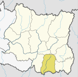
 Rangeli Location in Nepal | |
| Coordinates: 26°28′N 87°29′E / 26.46°N 87.49°ECoordinates: 26°28′N 87°29′E / 26.46°N 87.49°E | |
| Country |
|
| Zone | Kosi Zone |
| District | Morang District |
| Government | |
| • Mayor | Dilip Kumar Agrawal (NCP) |
| • Deputy Mayor | Keshav Kumari Kharel (NCP) |
| Population (1991) | |
| • Total | 12,325 |
| Time zone | UTC+5:45 (NST) |
| Postal code | 56602 |
| Area code(s) | 021 |
| Website | official website |
Rangeli is a Municipality and rural market town in Morang District in the Kosi Zone of south-eastern Nepal. This municipality was formed merging existing three villages i.e. Takuwa, Amgachhi and Rangeli itself since May 2014.[1][2]
At the time of the 1991 Nepal census it had a population of 12,325 people living in 2463 individual households.[3]
It is in the centre of a fertile agricultural region and there are numerous factories surrounding the town such as brick kilns and jute mills. Rangeli is linked by regular buses to the industrial city of Biratnagar.
Rangeli was once the district headquarters of Morang district, and was in the past a historically important trading town, although its role has declined over the last half a century with the growth of Biratnagar. Nevertheless, it remains an important market centre serving south-eastern Morang district.
References
- ↑ 72 new municipalities announced My Republica
- ↑ Govt announces 72 new municipalities The Kathmandu Post
- ↑ "Nepal Census 2001". Nepal's Village Development Committees. Digital Himalaya. Retrieved 14 December 2008.