Tehrathum District
| Tehrathum District तेह्रथुम | |
|---|---|
| District | |
 | |
| Country | Nepal |
| Province | Province No. 1 |
| Admin HQ. | Myanglung |
| Government | |
| • Type | Coordination committee |
| • Body | DCC, Tehrathum |
| Area | |
| • Total | 679 km2 (262 sq mi) |
| Population (2001) | |
| • Total | 113,111 |
| • Density | 170/km2 (430/sq mi) |
| Time zone | UTC+5:45 (NPT) |
| Main Language(s) | Limbu, Nepali |
| Website | ddctehrathum.gov.np |
Tehrathum District (Nepali: तेह्रथुम जिल्ला![]()
| Climate Zone[1] | Elevation Range | % of Area |
|---|---|---|
| Upper Tropical | 300 to 1,000 meters 1,000 to 3,300 ft. |
24.0% |
| Subtropical | 1,000 to 2,000 meters 3,300 to 6,600 ft. |
56.4% |
| Temperate | 2,000 to 3,000 meters 6,400 to 9,800 ft. |
19.5% |
Usually, the climate of Terathum district is moderate.
Village development committees (VDCs) and Municipalities
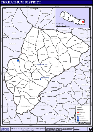
Tehrathum comprises total 32 village development committees (VDCs) or local administrative divisions, with nine sub-divisions within each VDC called wards.
By the restructured in 2017, the district have 6 local bodies called Municipalities (Nagarpalika) and Rural Municipalities (Gaunpalika):
- Aathrai Gaunpalika
- Phedap Gaunpalika
- Myanglung Nagarpalika
- Laligurans Nagarpalika
- Chhathar Gaunpalika
- Menchyayam Gaunpalika
See also
References
- ↑ The Map of Potential Vegetation of Nepal - a forestry/agroecological/biodiversity classification system (PDF), Forest & Landscape Development and Environment Series 2-2005 and CFC-TIS Document Series No.110., 2005, ISBN 87-7903-210-9, retrieved Nov 22, 2013
- "Districts of Nepal". Statoids.
External links
| Wikimedia Commons has media related to Tehrathum District. |
Places adjacent to Tehrathum District | ||||||||||
|---|---|---|---|---|---|---|---|---|---|---|
| ||||||||||
Headquarter: Myanglung | ||
| Rural Municipalities | | |
| Municipalities | ||
| Province No. 1 |  | |
|---|---|---|
| Province No. 2 | ||
| Province No. 3 | ||
| Gandaki Pradesh | ||
| Province No. 5 | ||
| Karnali Pradesh | ||
| Sudurpashchim Pradesh | ||
Coordinates: 27°15′N 87°35′E / 27.250°N 87.583°E