Province No. 2
| Province No. 2 प्रदेश नं. २ | ||
|---|---|---|
| Province | ||
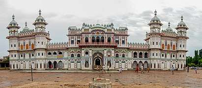 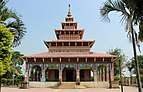  .jpg) 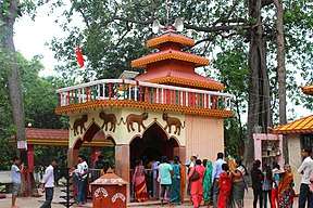 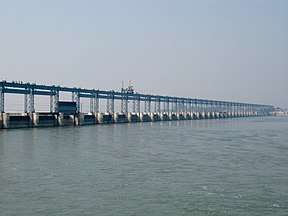 Anticlockwise from top Janaki Mandir, Kankalini Temple, Gateway of Nepal Birgunj, Chhinnamasta Temple, Gadhimai Temple and Koshi Barrage | ||
| ||
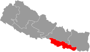 Location of Province No. 2 | ||
|
Map of Province No. 2, Nepal | ||
| Country |
| |
| Formation | 20 September 2015 | |
| Capital | Janakpur (Temporary) | |
| Largest city | Birgunj | |
| Districts | 8 | |
| Government | ||
| • Body | Government of Province No. 2 | |
| • Governor | Ratneshwar Lal Kayastha[1] | |
| • Chief Minister | Mohammad Lalbabu Raut Gaddhi (FSFN) | |
| • High Court | Janakpur High Court | |
| • Provincial Assembly | Unicameral (107 seats) | |
| • Parliamentary constituency | 32 | |
| Area | ||
| • Total | 9,661 km2 (3,730 sq mi) | |
| Area rank | 7th | |
| Population (2011) | ||
| • Total | 5,404,145 | |
| • Rank | 2nd | |
| • Density | 560/km2 (1,400/sq mi) | |
| • Density rank | 1st | |
| Demonym(s) | Madhesi but Nepali | |
| Time zone | UTC+5:45 (NST) | |
| Main Official Language | Nepali (6.67%) (under Constitution of Nepal) | |
| Other Official Language(s) |
1. Maithili (45.30%) 2. Bhojpuri (18.58%) | |
| HDI | 0.485 (low) | |
| Literacy | 49.54% | |
| Sex ratio | 101.18 ♂ /100 ♀ (2011) | |
| Website | http://p2.gov.np | |

Province No. 2 (proposed names: Madhesh, Mithila or Bhojpura)[2] (Nepali/Maithili: प्रदेश नं. २) is a province in the southeastern region of Nepal that was formed after the adoption of the Constitution of Nepal. It is Nepal's second most populous province,[3] and smallest province by area. It borders Province No. 1 and Province No. 3 to the north, and the Indian state of Bihar to the south. It has an area of 9,661 km2 (3,730 sq mi) with a population of 5,404,145 per the 2011 Census of Nepal, making it most densely populated province of Nepal.[4]
The province includes eight districts from Saptari District in the east to Parsa District in the west. The majority of the province's population speaks Maithili, Bhojpuri, Bajjika and Nepali.[4]
The sub-metropolitan city of Janakpur, also known as Janakpurdham,[5] is a centre for religious and cultural tourism.[6] It is also thought to have been the capital of the Videha dynasty that ruled Mithila region in ancient times.[5]
The first urban planned municipality of Nepal, Rajbiraj, is also the oldest municipality of the Terai belt of Nepal.[7][8][9] The town is believed to have been named after the ancient Rajdevi temple, which dates back to the 1700s. The metropolitan city of Birgunj is an economically important industrial centre and the only metropolitan city in the province.[10][11][12][13][14][15]
As per a 17 January 2018 cabinet meeting, Janakpur has been declared as the interim capital of Province No. 2.[16] Mohammad Lalbabu Raut Gaddhi is the current Chief Minister.[17][18]
Geography
The region is surrounded by:[19]
- The Sunsari District of Province No. 1 to the East.
- The Chitwan District of Province No. 3 to the West.
- The Makwanpur District and Sindhuli District of Province No. 3 and Udayapur District of Province No. 1 to the North.
- The Bihar state of India to the South.
As per Central Bureau of Statistics(CBS)[20] the province covers about 9,661 km2 (3,730 sq mi). of Nepal's total area of 147,181 km2 (56,827 sq mi). with total number of 5,404,145 inhabitants, it is the second most populous province in Nepal.[3][21]
Province No. 2 has no difficult terrains. The province is totally located on a flat plain land which is a part of Terai. Chure (Churiya) or the Shiwalik Hills are the natural border of the province which falls in northern side. The southern side has an international border with the Indian state of Bihar. Koshi River on its eastern side acting as a natural border with Province No. 1. Province No. 2 has eight districts in a series (parallel). Bagmati River, Kamla River, Lakhandei River, Bishnumati River are the main rivers of the province.
| Location | August
(°F) |
August
(°C) |
January
(°F) |
January
(°C) |
Annual
Precipitation (mm/in) |
|---|---|---|---|---|---|
| Gaur | 91/77.9 | 23/9.1 | 73.4/48.4 | 32.8/25.5 | 1590.2/62.6 |
| Siraha | 89.6/76.3 | 32/24.6 | 72.1/47.3 | 22.3/8.5 | 1293.1/50.9 |
| Birgunj | 84.7 | 29.3 | 60.8 | 16 | 1862.2/73.3 |
| Jaleshwar | 84.4 | 29.1 | 61.2 | 16.2 | 1492.9/58.8 |
| Malangwa | 84.4 | 29.1 | 60.8 | 16 | 1817.7/71.6 |
| Janakpur | 84.2 | 29 | 60.8 | 16 | 1516.5/59.7 |
| Rajbiraj | 83.3 | 28.5 | 60.4 | 15.8 | 1223.3/48.2 |
| Lahan | 83.3 | 28.5 | 60.3 | 15.7 | 1231.4/48.5 |
Government and administration
The Governor acts as the head of the province while the Chief Minister is the head of the provincial government. The Chief Judge of the Janakpur High Court is the head of the judiciary.[23] The present Governor, Chief Minister and Chief Judge are Ratneshwar Lal Kayastha (governor), Mohammad Lalbabu Raut (chief minister) and Udaya Prakash Chapagain.[24][25] The province has 107 provincial assembly constituencies and 32 House of Representative constituencies.[26]
Province No. 2 has a unicameral legislature, like all of the other provinces in Nepal. The term length of provincial assembly is five years. The Provincial Assembly of Province No. 2 is temporarily housed at the District Education Office in Janakpur.[27]
Administrative subdivisions
Province No. 2 is divided into eight districts, which are listed below. A district is administrated by the head of the District Coordination Committee and the District Administration Officer. The districts are further dived to municipalities or rural municipalities. The municipalities include one metropolitan city, three sub-metropolitan cities and 73 municipalities. There are 59 rural municipalities in the province.[28]
| # | Name | Nepali | Headquarters | Population (2011) | Area | Website |
|---|---|---|---|---|---|---|
| 1 | Saptari District | सप्तरी जिल्ला | Rajbiraj | 639,284 | 1,363 km² | |
| 2 | Parsa District | पर्सा जिल्ला | Birgunj | 601,017 | 1,353 km² | |
| 3 | Sarlahi District | सर्लाही जिल्ला | Malangwa | 769,729 | 1,259 km² | |
| 4 | Bara District | बारा जिल्ला | Kalaiya | 687,708 | 1,190 km² | |
| 5 | Siraha District | सिराहा जिल्ला | Siraha | 637,328 | 1,188 km² | |
| 6 | Dhanusha District | धनुषा जिल्ला | Janakpur | 754,777 | 1,180 km² | |
| 7 | Rautahat District | रौतहट जिल्ला | Gaur | 686,722 | 1,126 km² | |
| 8 | Mahottari District | महोत्तरी जिल्ला | Jaleshwar | 627,580 | 1,002 km² |
| Rank | District | Pop. | Rank | District | Pop. | ||||
|---|---|---|---|---|---|---|---|---|---|
Birgunj  Janakpur |
1 | Birgunj | Parsa | 240,922 | 11 | Bardibas | Mahottari | 66,354 |  Kalaiya  Jeetpur Simara |
| 2 | Janakpur | Dhanusha | 159,468 | 12 | Ishwarpur | Sarlahi | 59,986 | ||
| 3 | Kalaiya | Bara | 123,659 | 13 | Lalbandi | Sarlahi | 59,395 | ||
| 4 | Jeetpur Simara | Bara | 117,496 | 14 | Jaleshwor | Mahottari | 58,549 | ||
| 5 | Lahan | Siraha | 91,766 | 15 | Mahagadhimai | Bara | 54,474 | ||
| 6 | Siraha | Siraha | 82,531 | 16 | Golbazar | Siraha | 51,137 | ||
| 7 | Chandrapur | Rautahat | 72,059 | 17 | Garuda | Rautahat | 50,481 | ||
| 8 | Barahathwa | Sarlahi | 69,822 | 18 | Mirchaiya | Siraha | 50,079 | ||
| 9 | Rajbiraj | Saptari | 69,086 | 19 | Simraungadh | Bara | 49,939 | ||
| 10 | Gaushala | Mahottari | 66,673 | 20 | Manara Shiswa | Mahottari | 49,692 | ||
Religion in Province No. 2
Infrastructure
Transport
Province No. 2 has no difficult terrains still the means of transportation has not been developed in the region.
Roadways
The major connecting link for the province is the Mahendra Highway which runs longitudinally across the province. All major cities of the province remain disconnected from the highway. Janakpurdham, Rajbiraj and Birgunj lie 25,10 and 24 kilometres south of the Mahendra Highway, respectively.[29] The Tribhuvan Highway does not cross as much of the province as the Mahendra Highway, but it is equally important as it connects the province to Kathmandu and to the Indian states of Bihar and Uttar Pradesh.[30]
Railways
A few other railway projects are under progress in the province no. 2. All these projects are of Nepal Railways. Government of Nepal has proposed Janakpur as a Main Station for 1024 km east-west Metro Railway project and further be extended to India and China for connecting Nepal Railways with Indian Railways and China Railway for business and tourism promotion.[31]
Airways
Province No. 2 has 3 airports:
- Rajbiraj Airport, in Rajbiraj
- Janakpur Airport in Janakpur.
- Simara Airport in Pipara Simara close to Birganj.
- Nijgadh International Airport in Bara district.
See also
References
- ↑ "Provinces 2, 3 CMs expand cabinets". The Himalayan Times. 2018-03-01. Retrieved 2018-03-13.
- ↑ Yadav, S. (2018). "Province 2 struggles to reach consensus on its name". Nepal Republic Media Pvt. Ltd. Retrieved 29 March 2018.
- 1 2 Law, G. (2015). "Provinces of Nepal". statoids.com. Retrieved 23 February 2018.
- 1 2 "National Population and Housing Census 2011" (PDF). Central Bureau of Statistics. Retrieved 1 March 2014.
- 1 2 Burghart, R. (1978). The disappearance and reappearance of Janakpur. Kailash: A Journal of Himalayan Studies 6 (4): 257–284.
- ↑ Rastriya Samachar Samiti (2004). "More Indian tourists visit Janakpurdham". Himalayan Times, 17 January 2004.
- ↑ "राजविराज नगरपालिका". विकिपिडिया (in Nepali). 2017-10-06.
- ↑ "राजविराज नगरपालिका, नगर कार्यपालिकाकाे कार्यालय | प्रदेश नं. २, नेपाल सरकार". www.rajbirajmun.gov.np (in Nepali). Retrieved 2018-03-03.
- ↑ "Rajbiraj revisited − Nepali Times". nepalitimes.com. Retrieved 2018-03-03.
- ↑ "Birgunj Metropolitan City official Website". birgunjmun.gov.np.
- ↑ "Biratnagar, Birgunj promoted to Metropolitan Cities". The Himalayan Times. 2017. Retrieved 25 June 2017.
- ↑ "Possible headquarters of states". onlinekhabar.com.
- ↑ "Where will Province Chief live?". Naya Patrika Nepal's National News.
- ↑ "Possible Province headquarters". BroadNepal News Bnn.
- ↑ "कुन प्रदेशको राजधानी कहाँ ?". Himalayan Kangaroo.
- ↑ "Places proposed for temporary capitals of all seven provinces - News, sport and opinion from the Kathmandu Tribune's global edition". News, sport and opinion from the Kathmandu Tribune's global edition. 2018-01-02. Retrieved 2018-03-03.
- ↑ "Raut appointed Chief Minister of province-2 - News, sport and opinion from the Kathmandu Tribune's global edition". News, sport and opinion from the Kathmandu Tribune's global edition. 2018-02-14. Retrieved 2018-03-13.
- ↑ "Lalbabu Raut to be sworn in Province 2 CM today". The Himalayan Times. 2018-02-14. Retrieved 2018-03-13.
- ↑ "Big 3 draw new 7-province map". Republica. 22 Aug 2015. Retrieved 26 June 2017.
- ↑ "Statistical Year Book 2015 by CBS Nepal". Central Bureau of Statistics(CBS). Retrieved 26 June 2017.
- ↑ "The population of the provinces of Nepal according to census results and latest official projections". City Population. 29 Dec 2015. Retrieved 26 June 2017.
- ↑ "Nepal Travel Weather Averages (Weatherbase)". Weatherbase. Retrieved 2018-04-28.
- ↑ "High Courts get their chief judges". Retrieved 2018-04-27.
- ↑ "Lalbabu Raut appointed as Chief Minister of Province-2". My Republica. Retrieved 2018-04-27.
- ↑ "President of Nepal administers oath to Chiefs of seven provinces | DD News". ddnews.gov.in. Retrieved 2018-04-27.
- ↑ "CDC creates 495 constituencies". The Himalayan Times. 2017-08-31. Retrieved 2018-04-27.
- ↑ "First Provincial Assembly meeting begins in 4 provinces". Retrieved 2018-04-27.
- ↑ "स्थानिय तह". 103.69.124.141. Retrieved 2018-04-27.
- ↑ Reed, David (2002). The Rough Guide to Nepal. Rough Guides. ISBN 9781858288994.
- ↑ Highways in Nepal Archived 26 January 2010 at the Wayback Machine.
- ↑ Nepal,India agree on five rail projects
Places adjacent to Province No. 2 | ||||||||||
|---|---|---|---|---|---|---|---|---|---|---|
| ||||||||||
