Chhathar Jorpati
| Chhathar Jorpati छथर जोरपाटी गाउँपालिका | |
|---|---|
| Rural Municipality | |
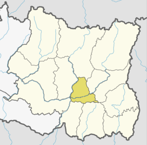
 Chhathar Jorpati Location in Province No. 1  Chhathar Jorpati Chhathar Jorpati (Nepal) | |
| Coordinates: 27°00′N 87°23′E / 27.00°N 87.39°ECoordinates: 27°00′N 87°23′E / 27.00°N 87.39°E | |
| Province | Province No. 1 |
| District | Dhankuta |
| Wards | 6 |
| Established | 10 March 2017 |
| Government | |
| • Type | Village Council |
| • Chairperson | Mr. Sher Bahadur Limbu |
| • Vice-chairperson | Mrs. Bhimkala Shrestha |
| Area | |
| • Total | 102.83 km2 (39.70 sq mi) |
| Population (2011) | |
| • Total | 18,322 |
| • Density | 180/km2 (460/sq mi) |
| Time zone | UTC+5:45 (Nepal Standard Time) |
| Headquarter | Tankhuwa |
| Website | official website |
Chhathar Jorpati (Nepali: छथर जोरपाटी गाउँपालिका) is a rural municipality (gaunpalika) out of four rural municipality located in Dhankuta District of Province No. 1 of Nepal. There are a total of 7 municipalities in Dhankuta in which 3 are urban and 4 are rural.
According to Ministry of Federal Affairs and Local Development Chhathar Jorpati has an area of 102.83 square kilometres (39.70 sq mi) and the total population of the municipality is 18322 as of Census of Nepal 2011. [1] [2] To form this new Rural Municipality Hathikharka, Tankhuwa, Telia and Parewadin were merged, which previously were all separate Village development committee (local level administrative villages).[1] Fulfilling the requirement of the new Constitution of Nepal 2015, Ministry of Federal Affairs and Local Development replaced all old VDCs and Municipalities into 753 new local level body (Municipality).
The Gaunpalika is divided into 6 wards and the Tankhuwa is the Headquarter of this newly formed rural municipality.
References
- 1 2 "स्थानीय तहहरुको विवरण". www.mofald.gov.np/en. MoFALD. Retrieved 13 April 2018.
- ↑ "CITY POPULATION – statistics, maps & charts". www.citypopulation.de. 8 October 2017. Retrieved 13 April 2018.