Taplejung Airport
| Taplejung Airport | |||||||||||
|---|---|---|---|---|---|---|---|---|---|---|---|
 Suketar airstrip | |||||||||||
| Summary | |||||||||||
| Airport type | Public | ||||||||||
| Owner | Government of Nepal | ||||||||||
| Serves | Taplejung district, Nepal | ||||||||||
| Coordinates | 27°21′3″N 87°41′42″E / 27.35083°N 87.69500°ECoordinates: 27°21′3″N 87°41′42″E / 27.35083°N 87.69500°E | ||||||||||
| Map | |||||||||||
 Taplejung Airport Location of airport in Nepal | |||||||||||
| Runways | |||||||||||
| |||||||||||
|
Source: [1] | |||||||||||
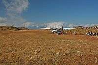
Taplejung Airport (IATA: TPJ, ICAO: VNTJ), also known asSuketar Airport is an airport serving Taplejung,[1] in the Taplejung district of the Mechi zone in Eastern Nepal.[2] It is the gateway for tourists heading to the Kangchenjunga mountainous area and Pathibhara Devi Temple. After its runway was blacktopped, Taplejung Airport restarted scheduled service in 2016.[3]
Airlines and destinations
| Airlines | Destinations |
|---|---|
| Nepal Airlines | Kathmandu[4] |
| Summit Air | Kathmandu[5] |
| Tara Air | Charter: Kathmandu[6] |
Gallery
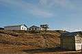 Suketar tower
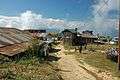 Suketar village
References
- 1 2 Airport information for Taplejung, Nepal (VNTJ / TPJ) at Great Circle Mapper.
- ↑ "Landowners pacified with compensation for Suketar airport". The Himalayan Times. 11 April 2010.
- ↑ "Suketar Airport, Taplejung, closed since 45 days". Repúblice. Retrieved 1 November 2017.
- ↑ "NAC to commence Regular Flights to Meghauli and Taplejung from Nov 29". Aviation Nepal. Retrieved 24 November 2017.
- ↑ "Flight Schedule". Summit Air. Archived from the original on 8 July 2017. Retrieved 15 October 2017.
- ↑ "Flight Schedule". Tara Air. Retrieved 15 October 2017.
See also
External links
| International | |||||
|---|---|---|---|---|---|
| Domestic |
| ||||
| Under construction | |||||
| Defunct | |||||
Unscheduled airports may be scheduled at certain times | |||||
This article is issued from
Wikipedia.
The text is licensed under Creative Commons - Attribution - Sharealike.
Additional terms may apply for the media files.