Kathmandu Valley
| UNESCO World Heritage site | |
|---|---|
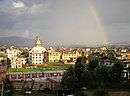
 Kathmandu valley seen from Palanse, Bhaktapur | |
| Location | Province No. 3, Nepal |
| Reference | 121bis |
| Inscription | 1979 (3rd Session) |
| Extensions | 2006 |
| Endangered | 2003–2007[1] |
| Area | 167.37 ha (413.6 acres) |
| Buffer zone | 70.29 ha (173.7 acres) |
| Coordinates | 27°42′14″N 85°18′31″E / 27.70389°N 85.30861°ECoordinates: 27°42′14″N 85°18′31″E / 27.70389°N 85.30861°E |
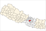
 Location of Kathmandu Valley in Nepal | |
The Kathmandu Valley (Nepali: काठमाडौं उपत्यका, Nepal Bhasa: स्वनिगः, नेपाः गाः), historically known as Nepal Valley or Nepa Valley, lies at the crossroads of ancient civilizations of the Indian subcontinent and the broader Asian continent, and has at least 130 important monuments, including several pilgrimage sites for Hindus and Buddhists. There are seven World Heritage Sites within the valley.[2]
Historically, the valley and adjoining areas made up a confederation known as the Nepal Mandala. Until the 15th century, Bhaktapur was its capital, when two other capitals, Kathmandu and Lalitpur (Patan), were established.[3] After the annexation of the valley by the Gorkha Kingdom, and subsequent conversion of the Valley as the capital of their empire, the designation of "Nepal" was extended to all the lands they had conquered.
The Kathmandu Valley is the most developed and populated place in Nepal. The majority of offices and headquarters are located in the valley, making it the economic hub of Nepal. It is popular with tourists for its unique architecture, and rich culture that includes the highest number of jatras (street festivals) in Nepal. The valley itself was referred to as "Nepal Proper" by British historians.
In 2015, Kathmandu Valley was hit by the April 2015 Nepal earthquake.[4] The earthquake caused thousands of deaths and destruction of many infrastructures across the Kathmandu Valley, which includes the towns of Lalitpur, Kirtipur, Madhyapur Thimi, Bhaktapur making the total population to roughly five million people and the municipalities across Kathmandu valley. Kathmandu is also the largest metropolis in the Himalayan hill region.
Etymology
Kathmandu is not the native name used by the indigenous Nepa people of the valley. The term "Nepa-al" means "land of the Nepa people" and was traditionally used to refer this valley.[5]
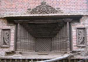
The Pahari name Kathmandu comes from a structure in Durbar Square called by the Sanskrit name Kāsṣtha mandapa "Wooden shelter". It was destroyed in the 2015 earthquake. This unique temple, also known as the Maru Sattal, was built in 1596 by King Lakshminarasimha Malla. The entire structure contained no iron nails or supports and was made entirely from wood. Legend has it that the timber used for this two-story pagoda was obtained from a single tree.
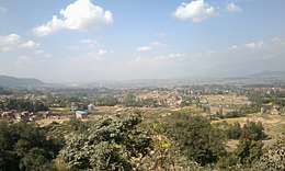
Area of Kavre
City of Banepa, Panauti and Dhulikhel is also considered part of Kathmandu valley as it has a similar culture.
History
The Kathmandu Valley may have been inhabited as early as 300 BCE, since the oldest known objects in the valley date to a few hundred years BCE. The earliest known inscription is dated 185 CE. The oldest firmly dated building in the earthquake-prone valley is over 2,000 years old. Four stupas around the city of Patan that are said to have been erected by a Charumati, a purported daughter of the Maurya emperor Ashoka, in the third century BCE, attest to the ancient history present within the valley. As with the tales of the Buddha's visit, there is no evidence supporting Ashok's visit, but the stupas probably date to that century. The Licchavis, whose earliest inscriptions date to 464, were the next rulers of the valley and had close ties with the Gupta Empire of India. The Mallas ruled the Kathmandu Valley and the surrounding area from the 12th until the 18th century CE, when the Shah dynasty of the Gorkha Kingdom under Prithvi Narayan Shah conquered the valley as he created present-day Nepal. His victory in the Battle of Kirtipur was the beginning of his conquest of the valley.
Newars
The Newars are the indigenous inhabitants and the creators of the historic civilization of the valley. Their language is today known as Nepal Bhasa.[6] They are understood to be the descendants of the various ethnic and racial groups that have inhabited and ruled the valley in the two-millennium history of the place. Scholars have also described the Newars as a nation.[7] They have developed a division of labour and a sophisticated urban civilization not seen elsewhere in the Himalayan foothills. They are known for their contributions to art, sculpture, architecture, culture, literature, music, industry, trade, agriculture and cuisine, and left their mark on the art of Central Asia.
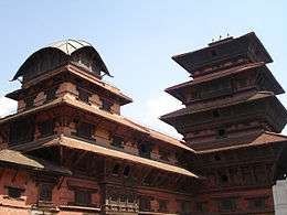
Newa architecture consists of the pagoda, stupa, shikhara, chaitya and other styles. The valley's trademark is the multiple-roofed pagoda which may have originated in this area and spread to India, China, Indochina and Japan.[8][9] The most famous artisan who influenced stylistic developments in China and Tibet was Araniko, a Newar who traveled to the court of Kublai Khan in the 13th century AD.[8] He is known for building the white stupa at the Miaoying Temple in Beijing. At present, people from other parts of Nepal tend to migrate to the valley for a better life due to its high level of cultural and economic development. Even with urbanization taking pace, the Newars have sustained their culture in Kathmandu Valley.
Mythology
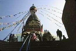
According to Swayambhu Puran, the Kathmandu Valley was once a lake, deemed by scientists as Paleo Kathmandu Lake. The hill where the Swayambu Stupa rests had lotus plants with flowers in bloom. One story says that the God Manjusri cut a gorge at a valley called Kashapaal (later called Chobhar) with a sword called Chandrahrasha and drained away the waters in order to establish a habitable land.
According to Gopal Banshawali, Krishna cut the gorge with his Sudarshana Chakra to let the water out. He then handed the drained valley to the Gopal Vansi people, who were nomadic cow herders.
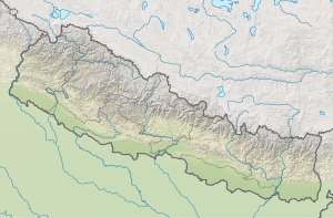
Geography
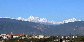
Kathmandu valley is bowl-shaped. Its central lower part stands at 1,425 metres (4,675 ft) above sea level. Kathmandu valley is surrounded by four mountain ranges: Shivapuri (at an elevation of 2,800 metres or 9,200 feet), Phulchowki (2,795 metres or 9,170 feet), Nagarjun (2,825 metres or 9,268 feet) and Chandragiri (2,551 metres or 8,369 feet). The major river flowing through the Kathmandu Valley is the Bagmati.
The valley is made up of the Kathmandu District, Lalitpur District and Bhaktapur District covering an area of 220 square miles (570 km2). The valley consists of the municipal areas of Kathmandu, Patan, Bhaktapur, Kirtipur and Madhyapur Thimi; the remaining area is made up of a number of municipalities and rural municipalities (in Lalitpur district). The valley is a cultural and political hub of Nepal. The Kathmandu valley was accorded the status of a World Heritage Site by UNESCO in the year 1979.
Places to see
This is an incomplete alphabetical list of notable temples and monuments in Kathmandu Valley. Seven of these are designated as UNESCO World Heritage Sites.[2]
- Bhaktapur District
- Bhaktapur Durbar Square (a UNESCO World Heritage Site)
- Changu Narayan Temple (a UNESCO World Heritage Site)
- Doleshwor Mahadeva Temple
- Kailashnath Mahadev Statue
- Suryavinayak Temple
- Kamal Binayak Temple
- Dattatreya Temple
- Kathmandu District
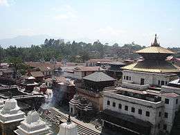
- Pashupatinath Temple (a UNESCO World Heritage Site)
- Aditnath Temple
- Boudhanath Stupa (a UNESCO World Heritage Site)
- Bagh Bhairab Temple
- Dakshinkali Temple
- Guhyeshwari Temple
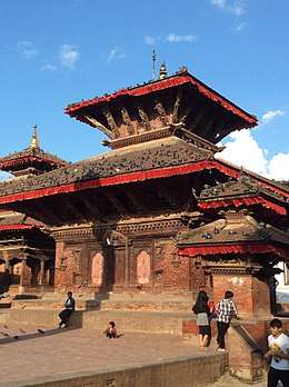
- Kathmandu Durbar Square (a UNESCO World Heritage Site)
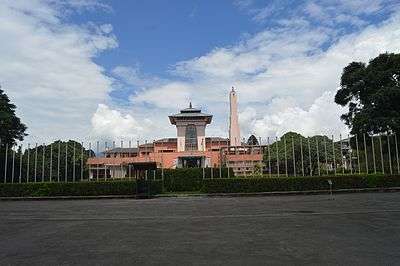
- Narayanhiti Palace
- Ranipokhari
- Swayambhunath Temple (a UNESCO World Heritage Site)
- Uma Maheshwar Temple
- Ajima Temple https://www.facebook.com/welcometomanamaiju/
- Jal Binayak Temple
- Chandra Binayak Temple
- Budhanilkantha Temple
- Lalitpur District, Nepal
- Patan Durbar Square (a UNESCO World Heritage Site)
- Temple of Rato Macchindranath, Bungmati
Present
This valley hosts a UNESCO World Heritage Site with seven preserved locations: the centers of the three primary cities, Kathmandu Hanuman Dhoka, Patan Durbar Square and Bhaktapur Durbar Square, the two most important Buddhist stupas, Swayambhunath and Boudhanath and two famous Hindu shrines, Pashupatinath temple and Changu Narayan.[10] In 2003, UNESCO listed the sites as being "endangered" out of concern for the ongoing loss of authenticity and the outstanding universal value of the cultural property. The endangered status was lifted in 2007.[11]
In the past, Tibetan Buddhist Masters including Marpa, Milarepa, Rwa Lotsava, Ras Chungpa, Dharma Swami, XIII Karmapa, XVI Karmapa and several others visited and travelled in the Kathmandu Valley. However, the largest group of Tibetans came in the 1960s. Many settled around the Swayambhunath and Boudhanath Stupas. Many other famous Lamas known throughout the world have their Buddhist monasteries and centers in the Kathmandu Valley.[12]
The 1500-year history of funerary architecture in the valley provides some of the finest examples of stone architecture found in the subcontinent. A caitya is placed in almost all courtyards in cities like Patan.[13] Stone inscriptions in the Kathmandu Valley are important sources for the history of Nepal.
Musical inspiration
- Cat Stevens wrote a song titled Katmandu, which appeared in his 1970 album, Mona Bone Jakon.
- Rock musician Bob Seger wrote a song titled Katmandu, which appeared on his 1975 album, Beautiful Loser.
- Kathmandu is mentioned in the song Cry Baby, by Janis Joplin.
- Kathmandu is also mentioned in the song Nobody Told Me, by John Lennon.
- A Russian rock band Krematorij had a song titled Kathmandu on their 2000 album Three Springs.
- The Argentine musician Fito Páez has a song called Tráfico por Katmandú (Traffic through Kathmandu in English).
- New age guitarist Will Ackerman has a song called A Happy Home in Kathmandu in his 1993 album The Opening of Doors.
- The group Tantra recorded a song called The Hills of Katmandu in the early 1980s.
- Banjo player Béla Fleck has a number called Kathmandu.
- David Hughes from Sweden included a track titled Kathmandu on his 2007 release Foreign Shores.
- Canadian prog-rock band Rush mentioned Kathmandu in the song A Passage To Bangkok on their 1976 album 2112.
- OK Go, an American band, have a song titled Back from Kathmandu.
- The English space rock band Hawkwind has a song called Kadu Flyer on their 1976 album Astounding Sounds, Amazing Music.
See also
References
- ↑ Royal Palaces of Abomey and Kathmandu removed from Danger List at UNESCO website
- 1 2 Centre, UNESCO World Heritage. "Kathmandu Valley". whc.unesco.org. Retrieved 8 September 2018.
- ↑ Slusser, Mary (1982). Nepal Mandala: A Cultural Study of the Kathmandu Valley. Princeton University. ISBN 978-0-691-03128-6. Page vii.
- ↑ "Nepal Disaster Risk Reduction Portal". Government of Nepal. Retrieved 5 May 2015.
- ↑ Rajendra S. Khadka Travelers' Tales Nepal
- ↑ von Furer-Haimendorf, Christoph (1956). "Elements of Newar Social Structure". Journal of the Royal Anthropological Institute. Royal Anthropological Institute of Great Britain and Ireland. 86: 15. doi:10.2307/2843991. JSTOR 2843991.
- ↑ "Mesocosm". publishing.cdlib.org. Retrieved 8 September 2018.
- 1 2 American University (Washington, D. C. ) Foreign Areas Studies Division; United States. Army (8 September 1964). "Area handbook for Nepal (with Sikkim and Bhutan)". Washington, For sale by the Supt. of Docs., U.S. Govt. Print. Off. Retrieved 8 September 2018 – via Internet Archive.
- ↑ ISBN 1-870838-76-9
- ↑ "places-to-see/unesco-world-heritage-sites".
- ↑ Centre, UNESCO World Heritage. "UNESCO World Heritage Centre - State of Conservation (SOC 2003) Kathmandu Valley (Nepal)". whc.unesco.org. Retrieved 2 October 2017.
- ↑ Observation on the influence of Tibetan Buddhism in the Kathmandu Valley: Archived 2008-11-20 at the Wayback Machine.
- ↑ Gutschow, Niels (1997). The Nepalese Caitya: 1500 Years of Buddhist Votive Architecture in the Kathmandu Valley. ISBN 978-3-930698-75-2. Pages 30-31.
External links
| Wikimedia Commons has media related to Kathmandu Valley. |
| Wikivoyage has a travel guide for Kathmandu Valley. |
- UNESCO – Kathmandu Valley
- UNESCO Advisory Board Evaluation
- Images from Kathmandu Valley
- 360° panorama images of Kathmandu valley
- Flickr.com – Scenes & Sights of Kathmandu Valley
- Under the Spell of Ancient Deities: writer Austin Pick recounts adventures traveling in the Kathmandu Valley
- Lyrics of the song "Kathmandu" by a Russian band