Maiwakhola
| Mauwakhola मौवाखोला | |
|---|---|
| Rural Municipality in Nepal | |
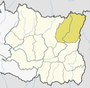
 Mauwakhola Location in Nepal | |
| Coordinates: 27°19′39.53″N 87°30′31.24″E / 27.3276472°N 87.5086778°ECoordinates: 27°19′39.53″N 87°30′31.24″E / 27.3276472°N 87.5086778°E | |
| Country | Nepal |
| Development Region | Eastern |
| Zone | Mechi |
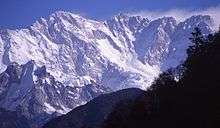
| District | Taplejung |
| Province | Province No. 1 |
| Rural Municipality | Mauwakhola |
| Established | 10 March 2017 |
| Government | |
| • Type | Gaunpalika |
| • Chairperson | Mr.Rajan Thatlung |
| • Vice-chairperson | Mrs.Kaushila Thatlung Limbu |
| Area | |
| • Total | 138 km2 (53 sq mi) |
| Population (2017)[1] | |
| • Total | 11,037 |
| • Density | 80/km2 (210/sq mi) |
| Time zone | UTC+5:45 (NST) |
| Website | Official Website |
Mauwakhola is a Gaupalika(Nepali: गाउपालिका ; gaupalika)(Formerly: village development committee) located in Taplejung District in the Mechi Zone of eastern Nepal. The local body was formed by merging three VDCs Fakumwa, Sanghu, Dhungesanghu. Currently, it has a total of 6 wards. The population of the rural municipality is 11,037 according to the data collected on Nepalese local elections, 2017.
Population
As per 2017, Mauwakhola hosts a population of 11,037 across a total area of 138km2.
See also
References
- ↑ "MOFALD List of Gaupalika" (PDF). Retrieved 2017-06-02.
This article is issued from
Wikipedia.
The text is licensed under Creative Commons - Attribution - Sharealike.
Additional terms may apply for the media files.