Bhotkhola
| Bhotkhola भोटखोला गाउँपालिका | |
|---|---|
| Rural Municipality | |
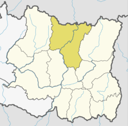
 Bhotkhola Location in Province No. 1  Bhotkhola Bhotkhola (Nepal) | |
| Coordinates: 27°46′N 87°20′E / 27.76°N 87.33°ECoordinates: 27°46′N 87°20′E / 27.76°N 87.33°E | |
| Province | Province No. 1 |
| District | Sankhuwasabha |
| Wards | 5 |
| Established | 10 March 2017 |
| Government | |
| • Type | Rural Council |
| • Chairperson | Mr. Temba Bhote |
| • Vice-chairperson | Mrs. Panjam Bhechyawa Bhote |
| Area | |
| • Total | 639.01 km2 (246.72 sq mi) |
| Population (2011) | |
| • Total | 6,576 |
| • Density | 10/km2 (27/sq mi) |
| Time zone | UTC+5:45 (Nepal Standard Time) |
| Headquarter | Hatiya |
| Website | official website |
Bhotkhola (Nepali: भोटखोला गाउँपालिका) is a rural municipality (gaunpalika) out of five rural municipality located in Sankhuwasabha District of Province No. 1 of Nepal. There are a total of 10 municipalities in Sankhuwasabha in which 5 are urban and 5 are rural.
According to Ministry of Federal Affairs and Local Development Bhotkhola has an area of 639.01 square kilometres (246.72 sq mi) and the total population of the municipality is 6576 as of Census of Nepal 2011. [1]
Kimathanka, Chepuwa, Hatiya and part of Pawakhola which previously were all separate Village development committee merged to form this new local level body. Fulfilling the requirement of the new Constitution of Nepal 2015, Ministry of Federal Affairs and Local Development replaced all old VDCs and Municipalities into 753 new local level body (Municipality).[1]
The rural municipality is divided into total 5 wards and the headquarter of this newly formed rural municipality is situated in Hatiya. [1]
References
- 1 2 3 "स्थानीय तहहरुको विवरण". www.mofald.gov.np/en. MoFALD. Retrieved 20 April 2018.