Udayapur District
| Udayapur District उदयपुर जिल्ला | |
|---|---|
| District | |
 A scene of Mahabharat hills in Udayapur | |
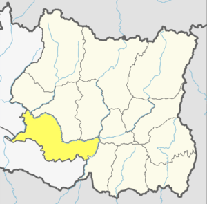 Udayapur district in Province No. 1 | |
 Political division of Udayapur | |
| Coordinates: 26°55′N 86°40′E / 26.917°N 86.667°E | |
| Country | Nepal |
| Province | Province No. 1 |
| Admin HQ. | Gaighat (Triyuga) |
| Municipality | |
| Government | |
| • Type | Coordination committee |
| • Body | DCC, Udayapur |
| • Head | Khadag Bahadur Pariyar |
| • Deputy-Head | Ganga Rai |
| • Parliamentary constituencies | 2 |
| • Provincial constituencies | 4 |
| Area | |
| • Total | 2,063 km2 (797 sq mi) |
| Highest elevation | 2,310 m (7,580 ft) |
| Lowest elevation | 360 m (1,180 ft) |
| Population (2011) | |
| • Total | 317,532 |
| Demographics | |
| • Ethnic Groups | Chhetri, Rai, Magar |
| • Female ♀ | 53% |
| Human Development Index | |
| • Literacy | 69% |
| Time zone | UTC+5:45 (NPT) |
| Postal Codes | 56300, 56301, 56302, 56303, 56305, 56306... 56312 |
| Telephone Code | 035 |
| Main Language(s) | Nepali, Magar, Tharu |
| Major highways | Sagarmatha |
| Website |
ddcudayapur |
Udayapur District (Nepali: उदयपुर जिल्ला![]()
The district border of Udayapur is drawn by Natural border with rivers and hills. Koshi river in the east of the district separates it from Sunsari District, Sun Kosi river in the north draw a borderline which separates it from Bhojpur and Khotang. Sindhuli District lies in the west across the Tawa khola and foothills of shiwalik in the south separates it from outer terai of Siraha and Saptari. Koshi Tappu Wildlife Reserve lies in the east occupying the area of Udayapur, Sunsari and Saptari District.
According to the former administrative divisions of Nepal, Udayapur falls in Eastern Development Region in Sagarmatha Zone.
History
Before the unification of modern Nepal by Shah kings. Udayapur District was under Sen dynasty. The Kingdom name was Chaudandi and capital of the Kingdom was Udayapurgadhi. The last king of the Chaudandi was Karna Sen who fled to Bijayapur when Gorkha army envaded and captured the Sen Kingdom Chaudandi.
Before 1972, Panchawati was Headquarter of Udayapur District, it moved to Gaighat in 1972.[2]
Geography and Climate
Udayapur district is surrounded by Mahabharat hills from north and Shiwalik from south, whereas both hills meet together by west which forms the region a valley Udayapur valley.[3] Udayapur valley is about 30 km long and between 2 km to 4 km wide, it is drained by the Triyuga river flowing east to join the Koshi river.
Forest cover takes up 67% of the total land area of the district. 28% of the land is cultivated. Small and large river and ponds remain the main source of water in the district. Ponds like Rauta Pokhari, Suke Pokhari, Tapli Pokhari, Jogidaha Chure Forest Pond and Jhilke Pokhari are key water resources in the district. The district does not possess larger lakes. Triyuga is the largest river in this district. Other two major rivers are Tawa Khola from Western side and Vaidyanath River from mid-side unite with Tawa River. Other rivers in the district are Kakaru Khola, Yari Khola, Rakula, Baruwa Khola, Andheri, Bahadura Khola and Rasuwa Khola. Sunkosi, Saptakosie, Kamala rivers lie on the district border.
This inner Terai district (low mid-hills) covers elevations between 360 metres to 2310 metres above sea level. Different topography, geology and altitude have established three distinct physiographic zones in the district as mentioned below.
Mahabharat hills
Mahabharat hill range in this district stretches from Sun Kosi River on northern side and links to Inner Terai and in some stretches, to Churiya hills. About 60% of the district is covered by middle hills with steep slope and rugged mountain topography. From nearly 1100 m to 2310 m, this land consists of high hills like Lekhani, Majhkharka, Rautapokhari.
Churiya hills
The Churiya hills stretch across elevations between 550 m to 1100 m. reaching from the upper Mahabharata to Terai land in the south leaving some plain inner Tarai land in between. It occupies about 9% of land of the district and consists of small valleys of inner Terai including Nepaltar, Murkuchi and Mainatar as well as plains like Bahuntar, Bhuttar, and Hardeni. These valleys are situated on Panchawati, Rauta, Bayaldanda and Tawashri VDC respectively.
Inner Terai region
This region occupies around 31% of the district at elevations between 360m to 550 m above sea level. This region is mainly situated on the border of Triyuga and Tawa River. Where inner Tarai exists the Churiya range lies to the south of this region. This region is highly affected by the problem of river cutting or floods. Major places of district like Gaighat, Katari and Beltar lie in this region.
| Climate Zone[4] | Elevation Range | % of Area |
|---|---|---|
| Lower Tropical | below 300 meters (1,000 ft) | 33.7% |
| Upper Tropical | 300 to 1,000 meters 1,000 to 3,300 ft. |
45.9% |
| Subtropical | 1,000 to 2,000 meters 3,300 to 6,600 ft. |
17.8% |
| Temperate | 2,000 to 3,000 meters 6,400 to 9,800 ft. |
0.5% |
Demographics
According to the census of 2011 the total population of Udaypur district is 317,532. Major ethnicities in the district are Chhetri (21.01%), Rai (17.09%), Magar (14.4%), Tharu (8.3%), Brahmin (7.31%) and others (32%). The literacy rate is 53.31 percent (CBS, 2001).
Administration
Udayapur District is administered by Udayapur District Coordination Committee (Udayapur DCC). The Udayapur DCC is elected by Udayapur District Assembly. The head of Udayapur DCC is Mr. Khadag Bahadur Pariyar (Darnal) and Mrs. Ganga Rai is deputy head of Udayapur DCC.
Udayapur District Administration Office under Ministry of Home Affairs co-operate with Udayapur DCC to maintain peace, order and security in the district. The officer of District Administration office called CDO and current CDO of Udayapur DAO is Bishnu Kumar Karkee.
Udayapur District Court is a Judicial court to see the cases of people on district level.
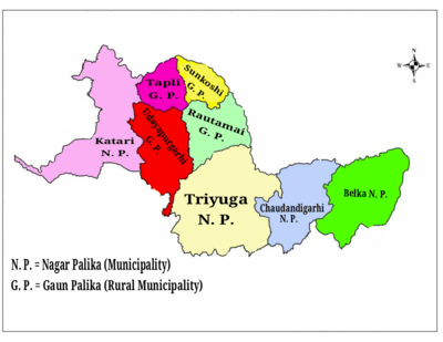
Division
Udayapur District is divided into total 8 local level bodies, 4 local level body categorized into Rural municipality and 4 into Municipality:
| # | Local body | Nepali | Population (2011) | Area (KM2) | Mayor | Deputy Mayor | Wards | Web |
|---|---|---|---|---|---|---|---|---|
| 1 | Triyuga | त्रियुगा | 87,557 | 547.43 | Baldev Chaudhari | Debi Kumari Chaudhari | 16 | |
| 2 | Katari | कटारी | 56,146 | 424.89 | Gyanendra Shresth | Bheem Kumari Rawat | 14 | |
| 3 | Chaudandigadhi | चौदण्डीगढी | 48,578 | 283.78 | Khagendra Rai | Rita Kumari Chaudhari | 10 | |
| 4 | Belaka | वेलका | 42,356 | 344.73 | Durga Kumar Thapa | Rajkumari Chaudhari | 9 | |
| 5 | Udayapurgadhi | उदयपुरगढी | 30,731 | 209.51 | Manbahadur Kepchaki Magar | Sanu Raut | 8 | |
| 6 | Rautamai | रौतामाई | 23,481 | 204.08 | Gajendra Kumar Khadka | Kumari Jyu Thakuri | 8 | |
| 7 | Tapli | ताप्ली | 14,562 | 119.11 | Uddab Singh Thapa | Kamalmaya Rai | 5 | |
| 8 | Limchungbung | सुनकोशी | 11,992 | 106.8 | Major Kumar Rai | Ramila Rai | 5 | |
| Udayapur | उदयपुर | 315,429 | 2300.33 | Khadag Bahadur Pariyar | Ganga Rai | 75 |
Former Administrative Divisions
Formerly, Udayapur had three municipality and many VDCs. VDCs were the local administrative units for villages.
Fulfilling the requirement of the new constitution of Nepal 2015, on 10 March 2017 all VDCs were nullified and formed new units after grouping VDCs.

| New adm. units | Former VDCs |
|---|---|
| Katari municipality | Former Katari Municipality, Triveni, Risku, Lekhani, Mayankhu, Hardeni, Limpatar, Shorung Chabise and Sirise |
| Chaudandigadhi municipality | Beltar Basaha Municipality, Chaudandi , Sithdipur, Hadiya and Sundarpur |
| Triyuga municipality | former Triyuga municipality, Jogidaha, Saune, Khanbu and Jalpachilaune |
| Belaka municipality | Tapeshwari, Rampur Thoksila, Mainamaini and Katunjebawala |
| Udayapurgadhi gaunpalika | Panchawati, Bhalayadanda, Tawasri, Dumre and Barre |
| Tapli gaunpalika | Rupatar, Thanagaun, Iname, Okhale and Lekhgaun |
| Rautamai gaunpalika | |
| Limchungbung | Basabote, Tamlichha, Baraha, Balamta and Jante |
Constituencies
Udayapur District is divided into 2 Parliamentary constituencies and 4 Provincial constituencies:
| Name of cons. | Incorporated areas | Type of cons. | MP/MLA | Party |
|---|---|---|---|---|
| Udayapur 1 | Triyuga ● Chaudandigadhi ● Belaka | Parliamentary constituency | Narayan Khadka | Nepali Congress |
| Udayapur 2 | Katari ● Udayapurgadhi ● Rautamai ● Tapli ● Limchungbung | Parliamentary cons. | Suresh Kumar Rai | Nepal Communist Party |
| Udayapur 1(A) | Chaudandigadhi● Belaka | Provincial cons. | Bimal Karki | Nepal Communist Party |
| Udayapur 1(B) | Triyuga | Provincial cons. | Himal Karki | Nepali Congress |
| Udayapur 2(A) | Udayapurgadhi ● Rautamai ● Limchungbung | Provincial cons. | Narayan Bahadur Magar | Independent |
| Udayapur 2(B) | Katari ● Tapli | Provincial cons. | Kala Ghale | Nepal Communist Party |
Transportation
Gaighat, the headquarter (center) of Udaydpur District is connected with NH-09 (Sagarmatha Highway), which connects Udayapur with NH-01 (East-west Highway) at Kadmaha. Kadmaha is 28 KM at distance from Gaighat. The NH-09 also connects Gaighat to Khotang which is 127 KM at distance from Gaighat but the road is not paved.[5]
Feeder Road F057 connects Gaighat to Chatara via Beltar-Basaha at 70 KM at distance in east which is across the Koshi river. The F057 feeder road also connects Sindhuli via Katari.[6]
Intresting Places
- Tribeni: It is a place in Katari municipality where the three rivers Kamla, Tawa and Dudhauli adjoins. It is visited by many devotees on the occasion of Makar (Maghe) Sankrati (first day of Nepali month of Magh) every year. On this occasion, a large fair is organized that lasts for about three weeks. [7]
- Rauta: Rauta is a holy place for Hindus located in Rautamai rural municipality. It is located on Mahabharat hills at the election of 2,000 feet (610 m) from sea level. There is a temple of Mahadev and a Pond called Rauta Pokhari. The pond is in the center of surrounded evergreen tall forest.[7]
- Koshi Tappu: Koshi Tappu is a protected area for wildlife. It is located in south-eastern part of Udayapur near Koshi River. Rampur is the nearest city in Udayapur from Koshi Tappu .
- Chaudandigadhi Durbar: The remains of Chaudandigadhi fort of Sen Kingdom[8] can be seen in Chaudandi. The kingdom of Chaudandigadhi was captured by Gorkha Army in 16 July 1773. The remains of Chaudandigadhi is now part of Chaudandigadhi municipality.
See also
References
- "Districts of Nepal". Statoids.
- ↑ "Udayapur District in Nepal Population". citypopulation.de. 7 October 2017. Retrieved 23 February 2018.
- ↑ "उदयपुरको पुरानो सदमुकाम उदयपुरगढीको यस्तो छ ऐतिहासिक तथ्य". thahakhabar.com (in Nepali). 25 April 2017. Retrieved 9 February 2018.
वि.स. २०२८ सालभन्दा अगाडि उदयपुर जिल्लाको सदरमुकाम हालको पञ्चावती गाविसमा पर्ने त्यही उदयपुरगढीमा थियो। पछि सदरमुकाम गाईघाटमा सारिएको हो।
- ↑ "Siwalik Hills Research and Development Group, SIRED". siwalikhills.org. Retrieved 23 February 2018.
Trijuga river valley ( Udayapur Dun valley), Nepal Intermittently located between the Siwaliks and the Lesser Himalayas or Mahabharat Hills (exclusively in India and Nepal) are Dun with flat-bottomed longitudinal structural valleys with their own drainage systems.
- ↑ The Map of Potential Vegetation of Nepal - a forestry/agroecological/biodiversity classification system (PDF), Forest & Landscape Development and Environment Series 2-2005 and CFC-TIS Document Series No.110., 2005, ISBN 87-7903-210-9, retrieved Nov 22, 2013
- ↑ "Nepal Road Distance Map". www.logcluster.org. Retrieved 27 April 2018.
- ↑ "Dharan-Chatara-Sindhuli-Hetauda road to be blacktopped within 3 yrs". www.myrepublica.com. My República. 18 Jan 2016. Retrieved 28 Apr 2018.
- 1 2 "Udayapur district (Gaighat)". www.honepal.com. Retrieved 27 August 2018.
- ↑ "A Visit To Chaudandi Gadhi [PHOTO]". www.aakarpost.com. Retrieved 27 August 2018.
External links
| Wikimedia Commons has media related to Udayapur District. |
Places adjacent to Udayapur District | ||||||||||
|---|---|---|---|---|---|---|---|---|---|---|
| ||||||||||
Headquarter: Triyuga | ||
| Municipality | | |
| Rural Municipality | ||
