Montagnac-d'Auberoche
| Montagnac-d'Auberoche | |
|---|---|
| Commune | |
 | |
 Montagnac-d'Auberoche Location within Nouvelle-Aquitaine region  Montagnac-d'Auberoche | |
| Coordinates: 45°11′15″N 0°57′23″E / 45.1875°N 0.9564°ECoordinates: 45°11′15″N 0°57′23″E / 45.1875°N 0.9564°E | |
| Country | France |
| Region | Nouvelle-Aquitaine |
| Department | Dordogne |
| Arrondissement | Sarlat-la-Canéda |
| Canton | Haut-Périgord Noir |
| Government | |
| • Mayor (2008–2014) | Gérard Devaux |
| Area1 | 10.02 km2 (3.87 sq mi) |
| Population (2008)2 | 135 |
| • Density | 13/km2 (35/sq mi) |
| Time zone | UTC+1 (CET) |
| • Summer (DST) | UTC+2 (CEST) |
| INSEE/Postal code | 24284 /24210 |
| Elevation | 128–255 m (420–837 ft) |
|
1 French Land Register data, which excludes lakes, ponds, glaciers > 1 km2 (0.386 sq mi or 247 acres) and river estuaries. 2 Population without double counting: residents of multiple communes (e.g., students and military personnel) only counted once. | |
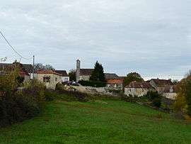
Montagnac-d'Auberoche is a commune in the Dordogne department in Nouvelle-Aquitaine in southwestern France. The village is situated on a hill near the river Auvézère, 19 km east of Périgueux.
Population
| Historical population | ||
|---|---|---|
| Year | Pop. | ±% |
| 1962 | 74 | — |
| 1968 | 102 | +37.8% |
| 1975 | 96 | −5.9% |
| 1982 | 99 | +3.1% |
| 1990 | 111 | +12.1% |
| 1999 | 105 | −5.4% |
| 2008 | 135 | +28.6% |
See also
References
External links
| Wikimedia Commons has media related to Montagnac-d'Auberoche. |
This article is issued from
Wikipedia.
The text is licensed under Creative Commons - Attribution - Sharealike.
Additional terms may apply for the media files.