Bieuzy
| Bieuzy Bieuzhi-an-Dour | |
|---|---|
| Commune | |
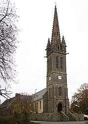 The church in Bieuzy | |
 Bieuzy Location within Brittany region  Bieuzy | |
| Coordinates: 47°59′00″N 3°03′46″W / 47.9833°N 3.0628°WCoordinates: 47°59′00″N 3°03′46″W / 47.9833°N 3.0628°W | |
| Country | France |
| Region | Brittany |
| Department | Morbihan |
| Arrondissement | Pontivy |
| Canton | Pontivy |
| Intercommunality | Pays de Baud |
| Government | |
| • Mayor (2008–2014) | Léon Quillère |
| Area1 | 18.98 km2 (7.33 sq mi) |
| Population (2009)2 | 754 |
| • Density | 40/km2 (100/sq mi) |
| Time zone | UTC+1 (CET) |
| • Summer (DST) | UTC+2 (CEST) |
| INSEE/Postal code | 56016 /56310 |
| Elevation | 37–176 m (121–577 ft) |
|
1 French Land Register data, which excludes lakes, ponds, glaciers > 1 km2 (0.386 sq mi or 247 acres) and river estuaries. 2 Population without double counting: residents of multiple communes (e.g., students and military personnel) only counted once. | |
Bieuzy (Bieuzhi-an-Dour in Breton) is a commune in the Morbihan department in Brittany in northwestern France.
Population
Inhabitants of Bieuzy are called Bieuzyates.
Sights
Prehistoric vestige
- Dolmen of Kermabon.
Church and chapels
- Notre-Dame, 16th century, in the form of a Latin cross.
- The chapel of Saint Gildas 16th century. Situated on the banks of the Blavet River, the chapel leans against an enormous rock which hangs over it. There is the natural grotto in which Saint Gildas may have taken shelter on his arrival from Cornwall in England. He is thought to have shared his hermitage with his disciple Bieuzy.
- The chapel of the Trinité (Trinity) at Castenec.
- The chapel of Saint-Samson, 16th century.
- the chapel of the Vraie-Croix (True Cross), 16th century.
Fountain
- The fountain of Saint Bieuzy, 16th century.
Mill
- The flour mill of Rimaison.
Curiosities
Memorial
- This memorial, located near the Gulf of Rimaison, is in memory of 14 Resistance fighters and French parachutists who were shot and killed at this spot on July 18, 1944.
See also
References
- INSEE statistics
- Mayors of Morbihan Association (in French)
External links
- Cultural Heritage (in French)
- Map of Bieuzy on Michelin (in English)
| Wikimedia Commons has media related to Bieuzy. |
This article is issued from
Wikipedia.
The text is licensed under Creative Commons - Attribution - Sharealike.
Additional terms may apply for the media files.