Garnet, Wisconsin
| Garnet, Wisconsin | |
|---|---|
| Unincorporated community | |
 Garnet, Wisconsin | |
| Nickname(s): Cream City | |
 Garnet, Wisconsin  Garnet, Wisconsin | |
| Coordinates: 43°56′08″N 88°15′46″W / 43.93556°N 88.26278°WCoordinates: 43°56′08″N 88°15′46″W / 43.93556°N 88.26278°W | |
| Country |
|
| State |
|
| County | Fond du Lac |
| Established | circa 1880 |
| Elevation | 287 m (942 ft) |
| Time zone | UTC-6 (Central (CST)) |
| • Summer (DST) | UTC-5 (CDT) |
| Zip codes | 53049 |
| Area code(s) | 920 |
| GNIS feature ID | 1565424[1] |
Garnet, Wisconsin is an unincorporated community in Fond du Lac County, in the U.S. state of Wisconsin.[2] The community is on the north boundary of the county, just south of Calumet County. It is located at the intersection of County Highway HHH and Town Hall Road just east of Calumet County C, in the town of Calumet.[3] Garnet is located 1.95 miles (3.14 km) east of Calumetville.
History
The community was settled in around 1880.[4] It is nicknamed "Cream City."[4]
Images
 Looking east at Garnet
- Looking west at Garnet on HHH
Notes
- ↑ "US Board on Geographic Names". United States Geological Survey. 2007-10-25. Retrieved 2008-01-31.
- ↑ http://www.wisconsinhistory.org/dictionary/index.asp?action=view&term_id=5558
- ↑ http://placenames.com/us/p1565424/
- 1 2 Edens, Mrs. Dale (January 18, 1973). "Historical Insight". Chilton Times-Journal.
Municipalities and communities of Fond du Lac County, Wisconsin, United States | ||
|---|---|---|
| Cities | 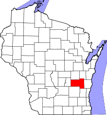 | |
| Villages | ||
| Towns | ||
| CDPs | ||
| Unincorporated communities |
| |
| Ghost towns/neighborhoods | ||
| Footnotes | ‡This populated place also has portions in an adjacent county or counties | |
This article is issued from
Wikipedia.
The text is licensed under Creative Commons - Attribution - Sharealike.
Additional terms may apply for the media files.