Silica, Wisconsin
| Silica, Wisconsin | |
|---|---|
| Unincorporated community | |
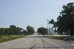 Looking south toward Silica, Wisconsin | |
 Silica, Wisconsin  Silica, Wisconsin | |
| Coordinates: 43°51′01″N 88°20′30″W / 43.85028°N 88.34167°WCoordinates: 43°51′01″N 88°20′30″W / 43.85028°N 88.34167°W | |
| Country |
|
| State |
|
| County | Fond du Lac |
| Elevation | 300 m (984 ft) |
| Time zone | UTC-6 (Central (CST)) |
| • Summer (DST) | UTC-5 (CDT) |
| Area code(s) | 920 |
| GNIS feature ID | 1574094[1] |
Silica, Wisconsin is an unincorporated community in the Town of Taycheedah in Fond du Lac County, Wisconsin. It is located at the intersection of County Highway QQ and Silica Road, approximately 1 mile (1.6 km) north of St. Peter.[2][3]
History
A post office called Silica was in operation from 1898 until 1904.[4] The community was so named on account of the sandy soil, Silica being the Latin word meaning "sand".[5]
Notes
- ↑ "US Board on Geographic Names". United States Geological Survey. 2007-10-25. Retrieved 2008-01-31.
- ↑ "Location of Silica, Wisconsin". Google Maps. Retrieved 26 December 2009.
- ↑ http://www.wisconsinhistory.org/dictionary/index.asp?action=view&term_id=4139
- ↑ "Fond du Lac County". Jim Forte Postal History. Retrieved 28 March 2015.
- ↑ Chicago and North Western Railway Company (1908). A History of the Origin of the Place Names Connected with the Chicago & North Western and Chicago, St. Paul, Minneapolis & Omaha Railways. p. 124.
Municipalities and communities of Fond du Lac County, Wisconsin, United States | ||
|---|---|---|
| Cities | 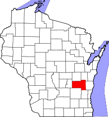 | |
| Villages | ||
| Towns | ||
| CDPs | ||
| Unincorporated communities |
| |
| Ghost towns/neighborhoods | ||
| Footnotes | ‡This populated place also has portions in an adjacent county or counties | |
This article is issued from
Wikipedia.
The text is licensed under Creative Commons - Attribution - Sharealike.
Additional terms may apply for the media files.