Karakul (Xinjiang)
The Karakul or Karakuli (Uyghur: قاراكۆل, ULY: Qaraköl , USY: Қаракөл, lit. "black lake"),[1] is a lake located 196 km southwest of Kashgar,[2] Xinjiang Uyghur Autonomous Region of China. It is located in Akto County, Kizilsu Kirgiz Autonomous Prefecture on the Karakoram Highway, before reaching Tashkurgan, the Khunjerab Pass on the China - Pakistan border and Sost in Pakistan.
| Karakul | |
|---|---|
 with Mt Kongur at the background | |
| Location | Xinjiang |
| Coordinates | 38°26′44″N 75°03′13″E |
| Basin countries | China |
| Surface area | 380 km2 (150 sq mi) |
| Max. depth | 242 m (794 ft) |
| Surface elevation | 3,645 m (11,959 ft) |
| Karakul | |||||||
|---|---|---|---|---|---|---|---|
| Chinese name | |||||||
| Traditional Chinese | 喀拉庫勒湖 | ||||||
| Simplified Chinese | 喀拉库勒湖 | ||||||
| |||||||
| Abbreviation | |||||||
| Chinese | 喀拉湖 | ||||||
| |||||||
| Kirghiz name | |||||||
| Kirghiz | Қарoкул | ||||||
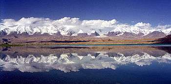
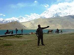
At an altitude of 3,600 m, it is the highest lake of the Pamir plateau, near the junction of the Pamir, Tian Shan and Kunlun mountain ranges. Surrounded by mountains which remain snow-covered throughout the year, the three highest peaks visible from the lake are the Muztagh Ata (7,546 m), Kongur Tagh (7,649 m) and Kongur Tiube (7,530 m). The lake is popular among travellers for its scenery and the clarity of its reflection in the water, whose color ranges from a dark green to azure and light blue. There are two Kirgiz settlements along the shore of Karakul lake, a small number of yurts about 1 km east of the bus drop-off point and a village with stone houses located on the western shores.
|

Footnotes
- Bonavia (2004), p. 348.
- Bonavia (2004), p. 337.
References
- Bonavia, Judy (2004).The Silk Road: X'ian to Kashgar. Odyssey Guides, Hong Kong. ISBN 962-217-741-7.
External links

- Pictures of Karakul Lake