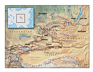
Altai Mountains
The Altai Mountains (/ɑːlˈtaɪ/), also spelled Altay Mountains, are a mountain range in Central and East Asia, where Russia, China, Mongolia, and Kazakhstan come together, and where the rivers Irtysh and Ob have their headwaters. The massif merges with the Sayan Mountains in the northeast, and gradually becomes lower in the southeast, where it merges into the high plateau of the Gobi Desert. It spans from about 45° to 52° N and from about 84° to 99° E.
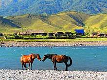
The region is inhabited by a sparse but ethnically diverse population, including Russians, Kazakhs, Altais, and Mongolians. The local economy is based on bovine, sheep, and horse husbandry, agriculture, forestry, and mining. The now-disputed Altaic language family takes its name from this mountain range.
᠊ᠢᠢᠨ
ᠨᠢᠷᠤᠭᠤ
Etymology and modern names
The name comes from the two words al that means "gold/reddish/yellowish" in Mongolic language and the -tai word that means "mountain" in Turkic languages too; thus, literally, the "Golden Mountain". That matches their old Chinese name 金山, literally "Gold Mountain". Also, the word altın/altun/al which means gold is cognate word for Turkic and Mongolic languages.
The mountains are called Altain nuruu (Алтайн нуруу) in Khalkha Mongolian, altai-yin niruɣu in Chakhar Mongolian, and Altay tuular (Алтай туулар) in the Altay language. They are also called Алтай таулары or التاي تاۋلارى in Kazakh; Altay dağları in Turkish; Altajskije gory (Алтайские горы) in Russian; Altay Taghliri (ىالتاي تاغلىرى or Алтай Тағлири) in Uyghur; ā'ěrtài shānmài in Chinese (阿尔泰山脉 simplified, 阿爾泰山脈 traditional, or اَعَرتَىْ شًامَىْ in Xiao'erjing); and Arteː shanmeː (Артэ Шанмэ) in Dungan.
Geography

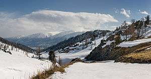
In the north of the region is the Sailughem Mountains, also known as Kolyvan Altai, which stretch northeast from 49° N and 86° E towards the western extremity of the Sayan Mountains in 51° 60' N and 89° E. Their mean elevation is 1,500 to 1,750 m. The snow-line runs at 2,000 m on the northern side and at 2,400 m on the southern, and above it the rugged peaks tower some 1,000 m higher. Mountain passes across the range are few and difficult, the chief being the Ulan-daban at 2,827 m (2,879 m according to Kozlov), and the Chapchan-daban, at 3,217 m, in the south and north respectively. On the east and southeast this range is flanked by the great plateau of Mongolia, the transition being effected gradually by means of several minor plateaus, such as Ukok (2,380 m) with Pazyryk Valley, Chuya (1,830 m), Kendykty (2,500 m), Kak (2,520 m), (2,590 m), and (2,410 m).[1]
This region is studded with large lakes, e.g. Uvs 720 m above sea level, Khyargas, Dorgon and Khar 1,170 m, and traversed by various mountain ranges, of which the principal are the Tannu-Ola Mountains, running roughly parallel with the Sayan Mountains as far east as the Kosso-gol, and the Khan Khökhii mountains, also stretching west and east.[1]
The north western and northern slopes of the Sailughem Mountains are extremely steep and difficult to access. On this side lies the highest summit of the range, the double-headed Belukha, whose summits reach 4,506 and 4,440 m respectively, and give origin to several glaciers (30 square kilometers in aggregate area, as of 1911).[1] Altaians call it Kadyn Bazhy, but is also called Uch-Sumer.[2] The second highest peak of the range is in Mongolian part named Khüiten Peak. This massive peak reaches 4374 m. Numerous spurs, striking in all directions from the Sailughem mountains, fill up the space between that range and the lowlands of Tomsk. Such are the Chuya Alps, having an average elevation of 2,700 m, with summits from 3,500 to 3,700 m, and at least ten glaciers on their northern slope; the Katun Alps, which have a mean elevation of about 3,000 m and are mostly snow-clad; the Kholzun range; the Korgon 1,900 to 2,300 m, Talitskand Selitsk ranges; the Tigeretsk Alps.[1]
Several secondary plateaus of lower elevations are also distinguished by geographers, The Katun Valley begins as a wild gorge on the south-west slope of Belukha; then, after a big bend, the river (600 km long) pierces the Katun Alps, and enters a wider valley, lying at an elevation of 600 to 1,100 m, which it follows until it emerges from the Altai highlands to join the Biya in a most picturesque region. The Katun and the Biya together form the Ob.[1]
The next valley is that of the Charysh, which has the Korgon and Tigeretsk Alps on one side and the Talitsk and Bashalatsk Alps on the other. This, too, is very fertile. The Altai, seen from this valley, presents the most romantic scenes, including the small but deep Kolyvan Lake (altitude 360 m), which is surrounded by fantastic granite domes and towers.[1]
Farther west the valleys of the Uba, the Ulba and the Bukhtarma open south-westwards towards the Irtysh. The lower part of the first, like the lower valley of the Charysh, is thickly populated; in the valley of the Ulba is the Riddersk mine, at the foot of the Ivanovsk Peak (2,060 m), clothed with alpine meadows. The valley of the Bukhtarma, which has a length of 320 km, also has its origin at the foot of the Belukha and the Kuitun peaks, and as it falls some 1,500 m in about 300 km, from an alpine plateau at an elevation of 1,900 m to the Bukhtarma fortress (345 m), it offers the most striking contrasts of landscape and vegetation. Its upper parts abound in glaciers, the best known of which is the Berel, which comes down from the Byelukha. On the northern side of the range which separates the upper Bukhtarma from the upper Katun is the Katun glacier, which after two ice-falls widens out to 700 to 900 metres. From a grotto in this glacier bursts tumultuously the Katun river.[1]
The middle and lower parts of the Bukhtarma valley have been colonized since the 18th century by runaway Russian peasants, serfs, and religious schismatics (Raskolniks), who created a free republic there on Chinese territory; and after this part of the valley was annexed to Russia in 1869, it was rapidly colonized. The high valleys farther north, on the same western face of the Sailughem range, are but little known, their only visitors being Kyrgyz shepherds.[1]
Those of Bashkaus, Chulyshman, and Chulcha, all three leading to the alpine lake of Teletskoye (length, 80 km; maximum width, 5 km; elevation, 520 m; area, 230.8 square kilometers; maximum depth, 310 m; mean depth, 200 m), are inhabited by Telengit people. The shores of the lake rise almost sheer to over 1,800 m. From this lake issues the Biya, which joins the Katun at Biysk, and then meanders through the prairies of the north-west of the Altai.[1]
Farther north the Altai highlands are continued in the Kuznetsk district, which has a slightly different geological aspect, but still belongs to the Altai system. But the Abakan River, which rises on the western shoulder of the Sayan mountains, belongs to the system of the Yenisei. The Kuznetsk Ala-tau range, on the left bank of the Abakan, runs north-east into the government of Yeniseisk, while a complexus of mountains (Chukchut, Salair, Abakan) fills up the country northwards towards the Trans-Siberian Railway and westwards towards the Ob.[1]
The Ek-tagh or Mongolian Altai, which separates the Khovd basin on the north from the Irtysh basin on the south, is a true border-range, in that it rises in a steep and lofty escarpment from the Dzungarian depression (470–900 m), but descends on the north by a relatively short slope to the plateau (1,150 to 1,680 m) of north-western Mongolia. East of 94° E the range is continued by a double series of mountain chains, all of which exhibit less sharply marked orographical features and are at considerably lower elevations. The slopes of the constituent chains of the system are inhabited principally by nomadic Kyrgyz.[1]
The five highest mountains of the Altai are:
- Belukha, 4,506 m (14,783 ft), Kazakhstan–Russia
- Khüiten Peak , 4,374 m (14,350 ft), China–Mongolia
- Mönkh Khairkhan , 4,204 m (13,793 ft), Mongolia
- Sutai Mountain , 4,220 m (13,850 ft), Mongolia
- Tsambagarav , 4,195 m (13,763 ft), Mongolia
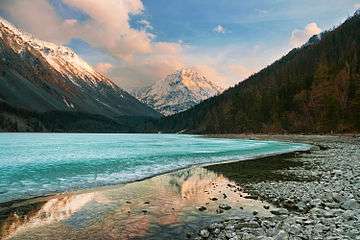
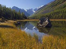
 Markakol reserve, Altay Mountains, Kazakhstan
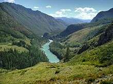 Katun River in the Altai Mountains
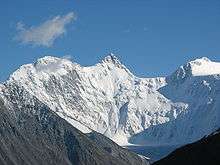
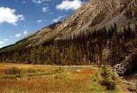 The Kucerla Valley in the Altai Mountains
Fauna
The Altai mountains are home to a diverse fauna, because of its different habitats, like steppes, northern taigas and alpine vegetation. Steep slopes are home to the Siberian ibex (Capra sibirica), whereas the rare argali (Ovis ammon) is found on more gentle slopes. Deer are represented by five species: Altai wapiti (Cervus elaphus sibiricus), moose (Alces alces), forest reindeer (Rangifer tarandus valentinae), Siberian musk deer (Moschus moschiferus), and Siberian roe deer (Capreolus pygargus). Moose and reindeer however, are restricted to the northern parts of the mountain range. The wild boar (Sus scrofa) is found in the lower foothills and surrounding lowlands. Until recently, the Mongolian gazelle (Procapra gutturosa) was found in the Russian Altai mountains, more specifically in the Chuya River steppe close to the Mongolian border. Large predators are represented by snow leopards (Panthera uncia, syn. Uncia uncia), wolves (Canis lupus), lynx (Lynx lynx), and brown bears (Ursus arctos), in the northern parts also by the wolverine (Gulo gulo).[3] The Tien Shan dhole (Cuon alpinus hesperius) (a northwestern subspecies of the Asiatic wild dog) also lives there.
Until the 20th century, the Caspian tiger (Panthera tigris virgata) was found in the southern parts of the Altai mountains, where it reached Lake Zaisan and the Black Irtysh. Single individuals were also shot further north, for example close to Barnaul.[4] Closely related to the Caspian tiger is the extant Amur tiger, which has the taxonomic name Panthera tigris altaica.[5]
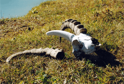
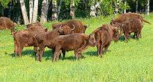
The wisent was present in the Altai mountains until the Middle Ages, perhaps even until the 18th century. Today, there is a small herd in a nursery in the Altai Republic.[6]
History and prehistory
The Altai mountains have retained a remarkably stable climate changing little since the last ice age.[7] In addition the mix of mammals has remained largely the same, with a few exceptions such as extinct mammoths, making it one of the few places on earth to retain an ice age fauna.[7]
The Altai mountains were home to the Denisovan branch of hominids who were contemporaries of Neanderthals and of Homo sapiens (modern humans), descended from Hominids who reached Asia earlier than modern humans.[7] The Denisova hominin, dated to 40,000 years ago, was discovered in the Denisova Cave of the Altai mountains in southern Siberia in 2008. Knowledge of the Denisovan humans derives primarily from DNA evidence and artifacts, as no complete skeletons have yet been recovered. DNA evidence has been unusually well preserved because of the low average temperature in the Denisova caves. Neanderthal bones and tools made by Homo sapiens have also been found in the Denisova Cave, making it the only place in the world where all three hominids are known to have lived.[7]
A dog-like canid from 33,000 years ago was found in the Razboinichya Cave.[8][9] DNA analysis published in 2013 affirmed that it was more closely related to modern dogs than to wolves.[10]
The Altai Mountains have been identified as being the point of origin of a cultural enigma termed the Seima-Turbino Phenomenon[11] which arose during the Bronze Age around the start of the 2nd millennium BC and led to a rapid and massive migration of peoples from the region into distant parts of Europe and Asia.
World Heritage site
.jpg)
A vast area of 16,178 km2—Altai and Katun Natural Reserves, Lake Teletskoye, Mount Belukha, and the Ukok Plateau—comprises a natural UNESCO World Heritage Site entitled Golden Mountains of Altai. As stated in the UNESCO description of the site, "the region represents the most complete sequence of altitudinal vegetation zones in central Siberia, from steppe, forest-steppe, mixed forest, subalpine vegetation to alpine vegetation". While making its decision, UNESCO also cited Russian Altai's importance for preservation of the globally endangered mammals, such as snow leopard and the Altai argali. Siberian ibex also live in these mountains.[12] The Uvs Nuur basin is also a protected site.
Violations of the protection status of Argali sheep and other species have been alleged, together with accusations of corruption, in the Altaigate Scandal. The incident arose from the death of several Russian VIPs in a helicopter crash early in 2009, purportedly on a poaching excursion.
Geology
The Siberian Altai represents the northernmost region affected by the tectonic collision of India into Asia. Massive fault systems run through the area, including the Kurai fault zone and the recently identified Tashanta fault zone. These fault systems are typically thrusts or right lateral strike-slip faults, some of which are tectonically active. Rock types in the mountains are typically granites and metamorphic schists, and some are highly sheared near to fault zones.
Seismic activity
Although earthquakes are generally rare occurrences, on 27 September 2003 a very large earthquake measuring MW 7.3 occurred in the Chuya Basin area to the south of the Altai region. This earthquake and its aftershocks devastated much of the region, causing $10.6 million in damage (USGS) and wiping out the village of Beltir.
See also
Notes
- Kropotkin 1911, p. 758.
- "Altai Republic :: official portal". Eng.altai-republic.ru. June 30, 1999. Archived from the original on March 16, 2012. Retrieved August 13, 2012.
- Klotz, Gerhard; et al. (1989). Hochgebirge der Erde und ihre Pflanzen und Tierwelt (in German). Leipzig: Urania Verlag. ISBN 3-332-00209-0.
- Mazak, Vratislav (2004). "Der Tiger". Nachdruck der 3. Auflage von 1983. Hohenwarsleben: Westarp Wissenschaften. ISBN 3-89432-759-6.
- Nowell, K.; Jackson, P. (1996). Wild cats: Status survey and conservation action plan. IUCN/SSC Cat Specialist Group, Gland, Switzerland. Retrieved 17 March 2016.
- Sipko, Taras P. (2009). "European bison in Russia – past, present and future". European Bison Conservation Newsletter. Band 2: 148–159. Archived from the original on March 2, 2018. Retrieved March 1, 2018.
- Colin Barras (January 23, 2014). "Ice-age animals live on in Eurasian mountain range". New Scientist. Retrieved March 4, 2014.
- Pritchard, Hamish (August 3, 2011). "Ancient dog skull unearthed in Siberia". BBC News. Retrieved August 4, 2011.
- Ovodov, Nikolai D.; Crockford, Susan J.; Kuzmin, Yaroslav V.; Higham, Thomas F. G.; Hodgins, Gregory W. L.; Plicht, Johannes van der (July 28, 2011). "A 33,000-Year-Old Incipient Dog from the Altai Mountains of Siberia: Evidence of the Earliest Domestication Disrupted by the Last Glacial Maximum". PLoS ONE. doi:10.1371/journal.pone.0022821. Cite journal requires
|journal=(help) - Druzhkova, Anna S.; Thalmann, Olaf; Trifonov, Vladimir A. (March 6, 2013). "Ancient DNA Analysis Affirms the Canid from Altai as a Primitive Dog". PLOS ONE. doi:10.1371/journal.pone.0057754.
- Keys, David (January 2009). "Scholars crack the code of an ancient enigma". BBC History Magazine. 10 (1): 9.
- "Greater Altai – Altai Krai, Republic of Altai, Tyva (Tuva), and Novosibirsk – Crossroads". Archived from the original on March 14, 2007. Retrieved 30 November 2006.
References

Authorities cited:
- P. Semenov and G. N. Potanin, in supplementary vol. of Russian ed. of Ritter's Asien (1877)
- Ledebour, Reise durch das Altaigebirge (1829–1830)
- P. Chikhatchev, Voyage scientifique dans l'Altai oriental (1845)
- Gebler, Übersicht des katunischen Gebirges (1837)
- G. von Helmersen, Reise nach dem Altai (St Petersburg, 1848)
- T. W. Atkinson, Oriental and Western Siberia (1858)
- Cotta, Der Altai (1871)
- Adrianov, "Journey to the Altai," in Zapiski Russ. Geogr. Soc. xi.
- Yadrintsev, "Journey in West Siberia," in Zapiski West Sib. Geogr. Soc. ii.
- Golubev, Altai (1890, Russian)
- Schmurlo, "Passes in S. Altai" (Sailughem), in Izvestia Russ. Geogr. Soc. (1898); xxxiv. 5
- V. Saposhnikov, various articles in same periodical (1897), xxxiii. and (1899) xxxv., and, by the same, Katun i yeya Istoki (Tomsk, 1901)
- S. Turner, Siberia (1905)
- Deniker, on Kozlov's explorations, in La Géographie (1901, pp. 41, &c.)
- P. Ignatov, in Izvestia Russ. Geog. Soc. (1902, No. 2).
External links
| Wikimedia Commons has media related to Altay Mountains. |
- Altai Mountains at the Encyclopædia Britannica
- "Ancient spirit and might preserved by indigenous people of Altay." on YouTube RT. 6 November 2011.
- Guide to the Mountain Altai – Welcome to Altai
- Photos of Mountain Altai – Altai-Photo
- Golden Mountains of Altai at Natural Heritage Protection Fund
- UNESCO's evaluation of Altai (PDF file)
Mountain ranges of China | |
|---|---|
| Northwest China | |
| Qinghai-Tibet and Southwest China | |
| Northeast China | |
| Northern China | |
| Central China | |
| Southern China | |