Tarim River
The Tarim River (Chinese: 塔里木河; pinyin: Tǎlǐmù Hé; Uyghur: تارىم دەرياسى, ULY: Tarim deryasi ), known in Sanskrit as the Śītā,[2] is an endorheic river in Xinjiang, China. It is the principal river of the Tarim Basin, a desert region of Central Asia between the Tian Shan and Kunlun Mountains. The river historically terminated at Lop Nur, but today reaches no further than Taitema Lake before drying out.
| Tarim | |
|---|---|
 | |
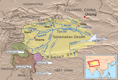 Map showing the rivers of the Tarim Basin | |
| Location | |
| Country | China |
| Location | Xinjiang |
| Physical characteristics | |
| Source | confluence of Yarkand and Aksu |
| Mouth | Taitema Lake |
⁃ coordinates | 39°28′N 88°19′E |
| Length | 1,321 km (821 mi)[1] |
| Basin size | 1,020,000 km2 (390,000 sq mi)[1] |
It is the longest inland river in China,[1] with an annual flow of 4 to 6 billion cubic metres (3,200,000 to 4,900,000 acre⋅ft) or 158.5 cubic metres per second (5,600 cu ft/s). Its basin is home to nearly 10 million Uyghur and other ethnic minorities.
Etymology
The word tarim is used to designate the bank of a river that flows into a lake or that is not able to be differentiated from the sands of a desert. This is a characteristic hydrographic feature of many rivers that traverse the sands of the Taklamakan Desert. Another characteristic of the rivers of the Tarim Basin, including the Tarim River itself, is their active migration, that is, the shifting of their beds and banks.
Geography and climate
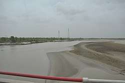
The total length of the Yarkand-Tarim river system is 2,030 kilometres (1,260 mi), although, as the Tarim frequently changes its channel, the length tends to vary over the years. It is shallow, unsuitable for navigation,[3] and because of its heavy silt load, forms a braided stream near its terminus. The area of the Tarim River Basin is about 557,000 square kilometres (215,000 sq mi). A considerable part of the Tarim's course is unformed, following no clearly defined riverbed. The water volume of the lower course of the river diminishes as a result of extensive evaporation and water-diversion schemes.
The Tarim's low-water period is from October through April. The spring and summer high waters begin in May and continue through September as the snows melt on the distant Tian Shan and Kunlun mountains.
The Lower Tarim Basin is an arid plain composed of alluvium and lake sediments and is bordered by massive mountain ranges. The basin is the driest region of Eurasia. The predominant part of it is occupied by the Taklamakan Desert, whose sand area exceeds 270,000 square kilometres (100,000 sq mi). In addition, there are several comparatively small sand massifs with areas of from 780 to 4,400 square kilometres (300 to 1,700 sq mi). Sand dunes are the predominant relief.
Precipitation in the Tarim Basin is extremely scant, and in some years it is nonexistent. In the Taklamakan Desert and in the Lop Nur basin, the average annual total of precipitation is about 12 millimetres (0.47 in). In the foothills and in several other areas of the river's basin, the precipitation amounts to from 50 to 100 millimetres (2.0 to 3.9 in) a year. In the Tian Shan it is much wetter, precipitation often exceeding 510 millimetres (20 in). Maximum temperatures in the Tarim Basin are about 40 °C (104 °F). The Tarim River freezes over every year from December through March.
Course
The Tarim River and most of its tributaries originate in the Karakorum and Kunlun Mountains. The name Tarim is applied to the river formed by the union of the Aksu River, flowing from the north, and Yarkand River, coming from the southwest, near the Aral City in western Xinjiang.[4] A third river, the Khotan River, comes to the same junction area from the south but it is usually dry at this location, having crossed the Taklamakan Desert to get here. Another river of western Xinjiang is the Kashgar River, which flows into the Yarkand River during the rainy season about 37 kilometres (23 mi) upstream from the Yarkand's confluence with the Aksu. By another definition, however, the Tarim starts at the Kashgar/Yarkand merger, and Aksu is considered just a tributary of the Tarim.
The Tarim flows in an eastward direction around the northern edge of the Taklamakan Desert.[4] It receives another tributary, the Muzat River from the north; however, out of these four rivers (Aksu, Yarkand, Khotan, and Muzart), only the Aksu flows into the Tarim year-round[5] It is the Tarim's most important tributary, supplying 70–80 percent of its water volume. Prior to the completion of reservoirs and irrigation works in the mid-20th century, the Tarim's waters eventually reached Lop Nur (now a salt-encrusted lake bed). The river's waters now drain intermittently into Taitema Lake, which is located about 160 kilometres (99 mi) southwest of Lop Nur.
Flora and fauna
Vegetation in the Tarim Basin is mainly located along the river and its branches. There, at the edge of the sands, shrubs like vegetation and stunted trees, especially wormwood, are found. Tugay poplar forest grows in the Tarim River valley. Underbrush consists of willows, sea buckthorn, and dense growths of Indian hemp and Ural licorice.
The Tarim River is rich in fish, and animal life on the river and the surrounding desert is varied. At the time of Sven Hedin's visit in 1899, tigers were still being hunted and trapped along the rivers of the region and near Lop Nur.[6][7] The valley and lakes of the Tarim are a stopover for many migratory birds.
Human use
Despite the Chinese government's promotion of large-scale irrigation, oasis agriculture remains the mainstay of the scattered settlements in the region. Grains, cotton, silk, fruits, and wool are the chief agricultural products, with Khotan jade being another important item.
Chinese authorities in the northwestern region of Xinjiang are relocating hundreds of ethnic minority farming families along the dwindling Tarim River. By 2008, more than 6,000 households along the river will have been resettled and cultivation forbidden along the river banks, in an attempt to save 60 million cubic meters (16 billion gallons) of water.
History
Some Chinese originally considered the Tarim to be the upper course of the Yellow River[8] but, by the time of the Former Han Dynasty (125 BCE–23 CE), it was known that it drains into Lop Nur, a series of salt lakes.[9] Its total length is 2,030 kilometres (1,260 mi).
Footnotes
- "5 Facts About The Tarim River". Retrieved 29 April 2018.
- Ram Rahul (2000) March of Central Asia, Indus Publishing
- "Tarim", in Barthold, W (1993), "Tarim", in Houtsma, Martijn Theodoor; Arnold, T W (eds.), E.J. Brill's first encyclopaedia of Islam, 1913-1936, Volume 1, BRILL, p. 673, ISBN 978-90-04-09796-4
- Hill (2009), p. 13.
- Vladimir B. Aizen and Elena M. Aizen (1998), Estimation of glacial runoff to the Tarim River, central Tien Shan. In: Hydrology, Water Resources and Ecology in Headwaters
- Hedin (1925), pp. 219, 233.
- Hill (2009), p. 160.
- Hill (2009), pp. 121, 161.
- Hulsewé and Loewe (1979), p. 72.
References
- Hedin, Sven (1925): My Life as an Explorer. First published Boni & Liveright, New York. Republished: National Geographic Adventure Classics. Washington, D.C. 2003.
- Hill, John E. (2009) Through the Jade Gate to Rome: A Study of the Silk Routes during the Later Han Dynasty, 1st to 2nd Centuries CE. John E. Hill. BookSurge, Charleston, South Carolina. ISBN 978-1-4392-2134-1.
- Hill, John E. 2004. The Peoples of the West from the Weilüe 魏略 by Yu Huan 魚豢: A Third Century Chinese Account Composed between 239 and 265 CE. Draft annotated English translation.
- Hulsewé, A. F. P. and Loewe, M. A. N. 1979. China in Central Asia: The Early Stage 125 BC – AD 23: an annotated translation of chapters 61 and 96 of the History of the Former Han Dynasty. E. J. Brill, Leiden.
- Stein, Aurel M. 1907. Ancient Khotan: Detailed report of archaeological explorations in Chinese Turkestan, 2 vols. Clarendon Press. Oxford.
- Stein, Aurel M. 1921. Serindia: Detailed report of explorations in Central Asia and westernmost China, 5 vols. London & Oxford. Clarendon Press. Reprint: Delhi. Motilal Banarsidass. 1980.
Suggested reading
- Baumer, Christoph. 2000. Southern Silk Road: In the Footsteps of Sir Aurel Stein and Sven Hedin. White Orchid Books. Bangkok.
- Mallory, J.P. and Mair, Victor H. 2000. The Tarim Mummies: Ancient China and the Mystery of the Earliest Peoples from the West. Thames & Hudson. London.
External links
- Information and a map of the Tarim's watershed
- Silk Road Seattle - University of Washington (The Silk Road Seattle website contains many useful resources including a number of full text historical texts)
- Satellite Image Based Map of the Tarim River Basin and Taklamakan Desert + Surrounding Mountain Ranges
- Photos of the Tarim River (from a Xinjiang blog)
| Authority control |
|
|---|