Naryn Region
Naryn Region (Kyrgyz: Нарын облусу, Narın oblusu/Naryn oblusu, نارىن وبلاستى) is the largest region (oblast) of Kyrgyzstan. It is located in the east of the country and borders with Chuy Region in the north, Issyk Kul Region in the northeast, Xinjiang Uyghur Autonomous Region of China in the southeast, Osh Region in the southwest, and Jalal-Abad Region in the west. Its capital is Naryn. The region was established on 21 November 1939 as Tien-Shan Region. On 20 December 1962 the region was dissolved, but on 11 December 1970 re-established again. On 5 October 1988 it was unified with Issyk-Kul Region, and, finally, on 14 December 1990 it got back its present name: Naryn Region.[2]
Naryn Region Нарын облусу Нарынская область | |
|---|---|
Region | |
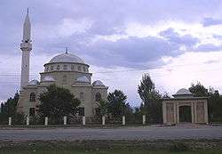 A mosque in Naryn | |
 Flag  Coat of arms | |
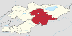 Map of Kyrgyzstan, location of Naryn Region highlighted | |
| Coordinates: 41°30′N 75°30′E | |
| Country | |
| Capital | Naryn |
| Government | |
| • Gubernator | Omurbek Suvanaliev |
| Area | |
| • Total | 45,200 km2 (17,500 sq mi) |
| Population (2020-01-01)[1] | |
| • Total | 289,621 |
| • Density | 6.4/km2 (17/sq mi) |
| Time zone | UTC+6 (East) |
| • Summer (DST) | UTC+6 (not observed) |
| ISO 3166 code | KG-N |
| Districts | 5 |
| Cities | 1 |
| Townships | 2 |
| Villages | 134 |
The main highway runs from the Chinese border at Torugart Pass north to Balykchy on Issyk Kul Lake. It is known as the location of Song Kol Lake and Chatyr-Kul Lake and Tash Rabat.
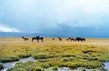
The population of Naryn oblast is 99% Kyrgyz. The economy is dominated by animal herding (sheep, horses, yaks), with wool and meat as the main products. Mining of various minerals developed during the Soviet era has largely been abandoned as uneconomical. Today the oblast is considered to be the poorest region in the country, but also the most typically Kyrgyz. It boasts beautiful mountains, alpine pastures and Son-Kul Lake which during summer months attracts large herds of sheep and horses with their herders and their yurts.
Demographics
As of 2009, Naryn Region contained 1 town (Naryn), 2 urban-type settlements, and 134 villages. Its population, according to the Population and Housing Census of 2009 amounted to 245.3 thousand (enumerated de facto population) or 257.8 thousand (de jure population).[3]The region's population estimate for the beginning of 2020 was 289,621. [1]
| Historical populations in Naryn Region | ||
|---|---|---|
| Year | Pop. | ±% |
| 1970 | 176,844 | — |
| 1979 | 213,887 | +20.9% |
| 1989 | 249,416 | +16.6% |
| 1999 | 248,699 | −0.3% |
| 2009 | 245,266 | −1.4% |
| Note: de jure population; Source:[3] | ||
Basic socio-economic indicators
Districts
Naryn Region is divided administratively into 5 districts [8]

| District | Capital |
|---|---|
| Ak-Talaa District | Baetov |
| At-Bashy District | At-Bashy |
| Jumgal District | Chaek |
| Kochkor District | Kochkor |
| Naryn District | Naryn |
References
- Population of regions,districts, towns, urban-type settlements, rural communities and villages of Kyrgyz Republic (National Statistical Committee estimate as of the beginning of 2020) Численность населения областей, районов, городов, поселков городского типа,айылных аймаков и сел Кыргызской Республики (оценка НСК на начало 2020г)
- Brief Description of Naryn Region (in Russian)
- "2009 population census of the Kyrgyz Republic: Naryn Region" (PDF). Archived from the original (PDF) on 25 October 2012. Retrieved 15 June 2016.
- National Committee on Statistics (in Kyrgyz/Russian) Archived 14 November 2010 at the Wayback Machine
- National Committee on Statistics (in Kyrgyz/Russian) Archived 14 November 2010 at the Wayback Machine
- National Committee on Statistics (in Kyrgyz/Russian) Archived 22 July 2011 at the Wayback Machine
- National Committee on Statistics (in Kyrgyz/Russian) Archived 22 July 2011 at the Wayback Machine
- Kyrgyzstan - Джалал-Абадская область
Works cited
- Laurnnce Mitchell, Kyrgyzstan, Bradt Travel Guides, 2008
Places adjacent to Naryn Region | ||||||||||
|---|---|---|---|---|---|---|---|---|---|---|
| ||||||||||