Akto County
Akto County (also as Aketao; Chinese: 阿克陶县; pinyin: Ākètáo Xiàn) is a county in Xinjiang Uygur Autonomous Region, China. It is under the administration of the Kyrgyz autonomous prefecture of Kizilsu. The county has two towns, 11 townships, four state-owned farms and a plant nursery under its jurisdiction, the county seat is Akto Town. The county contains an area of 24,555 km2 (9,481 sq mi) and has a population of 231,756 (as of 2017[3]).
Akto County 阿克陶县 ئاقتو ناھىيىسى | |
|---|---|
County | |
.png) Location of the county (red) in Kizilsu Prefecture (yellow) and Xinjiang | |
| Coordinates: 39.1478427995°N 75.9473689839°E | |
| Country | People's Republic of China |
| Autonomous region | Xinjiang |
| Autonomous prefecture | Kizilsu Kirghiz Autonomous Prefecture |
| County seat | Akto town |
| Area | |
| • Total | 24,176 km2 (9,334 sq mi) |
| Population (2015)[2] | |
| • Total | 221,526 |
| Time zone | UTC+8 (China Standard Time) |
| Area code(s) | 653022 |
| Website | www |
| Akto County | |||||||||||
|---|---|---|---|---|---|---|---|---|---|---|---|
| Chinese name | |||||||||||
| Simplified Chinese | 阿克陶县 | ||||||||||
| Traditional Chinese | 阿克陶縣 | ||||||||||
| |||||||||||
| Uyghur name | |||||||||||
| Uyghur | ئاقتو ناھىيىسى | ||||||||||
| |||||||||||
| Kyrgyz name | |||||||||||
| Kyrgyz | ﺍﻗﺘﻮﻭ وودانى Актоо ооданы Aqtoo oodanı | ||||||||||
Akto is the westernmost border county of China. A point north of the Markansu River (瑪爾坎蘇河) on the China–Tajikistan border is the westernmost point of China. The county is located in the southwest of Xinjiang Uygur Autonomous Region, east of the Pamir Plateau, and the western edge of the Tarim Basin. It is located between 73°26'5" - 76°43'31" east longitude and 37°41'28" - 39°29'55" north latitude. It is bordered by Wuqia County and Shufu County to the north, by Shule County and 41st Regiment of the XPCC across Yuepuhu River (岳普湖河) to the northeast, by Yingjisha County, Shache County to the east, by Tashkurgan County to the south. The west and south-west are connected with the Kyrgyzstan and the Tajikistan, the border line is more than 380 kilometers long.[4]
History
In the early years of the Western Han dynasty, the land of the present Akto County was under the jurisdiction of three Kingdoms of Shule, Puli (蒲犁国) and Yilai (依耐国). In 60 BC, the Han dynasty set up the Protectorate of the Western Regions in Wulei Fortress (乌垒城; near the present Yungou, Dongye Town in Luntai County; 今轮台东野云沟附近), and Akto was under its jurisdiction. During the Three Kingdoms period, Akto was still under the jurisdiction of the Wei State. During the Jin dynasty, Akto County was part of Shule Kingdom of Jin. In 658, with the establishment of Kara-Khanid Khanate, most of Akto was under its jurisdiction. In 1134, Akto was part of West Liao with the East Kara-Khanid Khanate reconciled itself to West Liao. In 1226, the Southern Tianshan was in the territory of Chagatai Khanate, Akto under its control. With establishment of the Eastern Chagatai Khanate in 1347, Akto was one of the dominions of the khanate supervisor Hudaida (忽歹达). Akto was part of Yarkent Khanate in 1514. In 1678, the Dzungar began to rule the place of the present Akto. After the Qing dynasty calmed the Revolt of the Altishahr Khojas in 1759, the land was ruled by Kashgar and Yarkand officials (喀什噶尔和叶尔羌参赞大臣). Appointed officials of circuits, prefectures and counties in the southern Xinjiang in 1883, Akto was under the jurisdiction of Yengisar Independent Prefecture (英吉沙尔直隶厅), Shule Independent Prefecture (疏勒直隶州) and Puli Independent Sub-prefecture of Shache (莎车府蒲犁分防厅).
Akto County was established in August 1954 from parts of Yingjisha, Shufu, Puli (present Tashkurgan) and Wuqia counties. The present Yumai Township (玉麦乡) was from the 6th district in Yingjisha, Piral Township (皮拉勒乡) and Barin Township (巴仁乡) from the 7th district in Yingjisha, Kizilto Township (克孜勒陶乡) from the 8th district in Yingjisha, Qiarlon Township (恰尔隆乡) from 4th district of Qiarlon (恰尔隆第四区) in Puli County, Blunko Township (布伦口乡) from 5th district of Blunko (布伦口五区) in Puli and two townships of Bostanterak District (波斯坦铁热克区) in Wuqia County, Auytak Town (奥依塔克镇) from Auytak Township (奥依塔克乡) in Shufu County, Karekayqik Township (喀热开其克乡) from Qlukbash Township in Shufu.[5]
The 2007 Xinjiang raid occurred in the county.
Geography
Akto County is located in the central hinterland of Asia, the westernmost part of China, the southwest of Xinjiang Uygur Autonomous Region, the eastern Pamir Plateau, and the western edge of the Tarim Basin. It is located between east longitude 73°26'5" - 76°43'31" and north latitude 37°41'28" - 39°29'55". Its maximum length from north to south is 283.2 kilometers long from the middle section of Maltabar Mountain (玛里他巴尔山) in the northwest to The Kokluk Farm (科克鲁克农场) in Kuslap Township (库斯拉甫乡) in the southeast; The maximum length from west to east is 216 kilometers long from Subash Village (苏巴什村) in Bulunkou Township (布伦口乡) in the southwest to the Jamaterak Township (加马铁热克乡) in the northeast. The county terrain is high in the northwest and low in the southeast and runs northwest to southeast, with a total area of 24,555 square kilometers.[4]
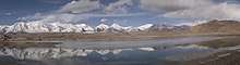
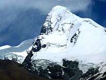
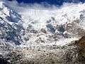
Akto County is located in the three major geographic regions of the Pamirs, the northern slopes of the Kunlun Mountains and the oasis on the western edge of the Tarim Basin. The landform is dominated by mountains, with the mountainous area accounting for 96.39% of the total area of the county, and the mountainous areas generally at an altitude of 4,000-5,000 meters. The Kungay Mountain (昆盖山) in the northwest is the boundary mountain of the county with Wuqia County, with an elevation of 5,753.7 meters. The Sarikol Range (萨雷阔勒岭) in the southwest is more than 4,500 meters above sea level; the highest peak of Kongur Tagh (公格尔山) in the central part is 7,719 meters above sea level, the peak of Kongur Tiube (公格尔九别峰) is 7,530 meters high above sea level, and the peak of Muztagh Ata (慕士塔格峰) is 7,541 meters high. There are 66 snow-capped peaks in the territory, including 36 large ice peaks. The mountaintops have snow all the year round, and there are glaciers of different sizes around the peaks. The landform features severe drought and erosion, bare mountain and sparse vegetation. Due to the different rock types of the mountains, they are gray, black, yellow, red and white bare mountains. Many mountain bodies are red, gray, yellow and other colors.
The midwestern part of the county is the undulating Pamir Plateau. Several giant mountains on the Asian continent - the Himalayas, the Karakoram Range, the Kunlun Mountains, the Tian Shan Mountains and the Hindu Kush Mountains are all gathered here. The main mountain range of the Pamirs is Kongur -Muztagh Mountains (公格尔-慕士塔格山), which is mainly in Akto County. It extends southward to Tashkurgan County and extends to the northeast to Yingjisha and Yecheng counties. Muztagh is the boundary mountain between Akto County and Tashkurgan County, the top of the mountain is accumulating ice and snow, and the thickness of snow is more than 100 meters. There are more than 40 modern glaciers distributed below the snow line. The thickness of the ice sheet is 100 meters. The glacial meltwater is the main source of agricultural irrigation in the county, and it is also the main source of supply for the Gez River (盖孜河) and the Kushan River (库山河).
The southern part of Akto County is the northern slope of Kunlun Mountains, which is the main mountain of the Kunlun. In addition to the Jogori Peak, the other three famous peaks of Muztagh Ata, Kongur Tagh and Kongur Tiube are almost all in Akto. Kunlun is famous for its jade production. It is located in the mountains of Akto in the upper reaches of the Yarkand River. There are many jade mines. These jade stones exposed in the rock formations by the river are washed into the riverbed in the lower reaches by water, and stepping on jade in the Yarkand River has become a production activity and industry that the locals have been engaged for thousands of years.
The northeastern part of the county is a vibrant oasis, located on the southwestern edge of the Tarim Basin and part of the Tarim Oasis. The plain agricultural areas in the county are mainly divided into two parts, one is the front flood fan of the Pamir Mountains, and the other is the Gez-Kushan River Delta (盖孜-库山河三角洲). These two plains, in terms of large landform types, belong to the Kashgar Delta (喀什噶尔三角洲) and are an oasis on the southwest edge of the Tarim Basin. The Gez-Kushan River Delta, located in the southern part of the Kashgar Plain (喀什噶尔平原), the northern part of the northern slope of the Pamir-West Kunlun Mountain Range, the triangle between the Gez and the Kushan rivers, covers an area of about 800 square kilometers, has a distribution population of more than 100,000, accounting for about 68% of the total population of the county. It is composed of the flood of the Gez river and the Kushan River - alluvial fan and Gez River - the dympastain plain saticity of the Yuepuhu River, mainly including Akto Town, Yumai, Barin, Pilal, Jamaterak and other agricultural areas. The area is flat, at an altitude of about 1,200 to 15,00 meters, with abundant water and fertile land, most of which are agricultural oasis.[4]
Administrative divisions
The county has 12 township-level administrative divisions under its jurisdiction, it has statistically 12 township-level administrative divisions and five state-owned farms in the county.[6]
2 towns and 10 townships
- Akto Town (阿克陶镇)
- Oytak Town (奥依塔克镇)
- Ojma Township (玉麦乡)
- Pilal Township (皮拉勒乡)
- Barin Township (巴仁乡)
- Karakeqik Township (喀热克其克乡)
- Jamaterek Township (加马铁热克乡)
- Muji Township (木吉乡)
- Bulungkol Township (布伦口乡)
- Kizilto Township (克孜勒陶乡)
- Qarlung Township (恰尔隆乡)
- Tar Tajik Township (塔尔塔吉克族乡)
2 state-owned farms of Akto County
- Turtay Farm of Akto County (托尔塔依农场)
- Akdala Farm of Akto County (阿克达拉牧场)
2 state-owned nurseries of Akto County
- Signature Animal Nursery (原种场)
- Plant Nursery (苗圃)
1 state-owned forest farm of Kizilsu Prefecture
- Forest Farm of Kizilsu (克州林场)
Demographics
As of 2015, 161,687 of the 221,526 residents of the county were Uyghur, 45,279 were Kyrgyz, 8,347 were Han Chinese, 5,759 were Mountain Tajik (China) and 454 were from other ethnic groups.[7]
Transportation
Akto is served by the Kashgar-Hotan Railway.
.jpg)


References
- 史志办 (4 June 2018). 行政区划. 阿克陶县人民政府 (in Chinese). Retrieved 29 January 2020.
总面积24176平方千米。
- 2015 population of Akto, Based on the Xinjiang Statistical Yearbook 2016 edited by Xinjiang Bureau of Statistics; pubished by China Statistics Press; ISBN 978-7-5037-7902-2
- 阿克陶县2017年国民经济和社会发展统计公报 (in Chinese). xjakt.gov.cn. 2018-07-20. Retrieved 2019-10-24.
- 阿克陶县地理概况 (in Chinese). xjakt.gov.cn. 2018-12-24. Retrieved 2019-10-24.
- 阿克陶县历史变迁(一) (in Chinese). xjakt.gov.cn. 2018-06-04. Retrieved 2019-10-24.
- 2018年阿克陶县行政区划代码. National Bureau of Statistics of China. 2018-10-31. Retrieved 2019-10-28.
- 3-7 各地、州、市、县(市)分民族人口数 (in Chinese). شىنجاڭ ئۇيغۇر ئاپتونوم رايونى 新疆维吾尔自治区统计局 Statistic Bureau of Xinjiang Uygur Autonomous Region. Archived from the original on 2017-10-11. Retrieved 2017-09-03.
| Authority control |
|
|---|