West Chester, Pennsylvania
| West Chester | |
|---|---|
| Borough | |
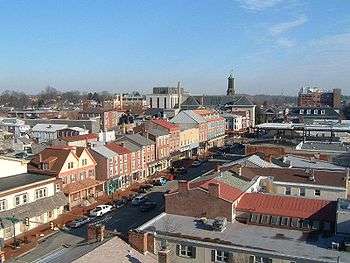 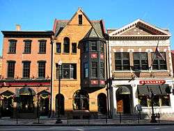   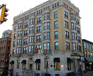 From top left: (1) West Chester Downtown Historic District, (2) Buckwalter Building, (3) West Chester University of Pennsylvania, (4) Chester County Courthouse, and (5) Farmers and Mechanics Building. | |
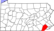
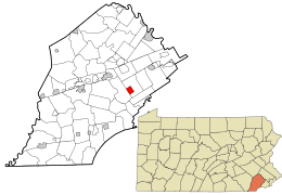 Location in Chester County and the U.S. state of Pennsylvania. | |
 West Chester Location of West Chester in Pennsylvania.  West Chester West Chester (the US) | |
| Coordinates: 39°57′31″N 75°36′18″W / 39.95861°N 75.60500°WCoordinates: 39°57′31″N 75°36′18″W / 39.95861°N 75.60500°W | |
| Country |
|
| State |
|
| County |
|
| Government | |
| • Mayor | Dianne Herrin |
| Area[1] | |
| • Total | 1.85 sq mi (4.78 km2) |
| • Land | 1.85 sq mi (4.78 km2) |
| • Water | 0.00 sq mi (0.00 km2) |
| Elevation | 446 ft (136 m) |
| Population (2010) | |
| • Total | 18,461 |
| • Estimate (2016)[2] | 19,928 |
| • Density | 10,795.23/sq mi (4,167.60/km2) |
| Time zone | UTC-5 (EST) |
| • Summer (DST) | UTC-4 (EDT) |
| ZIP Codes | 19380-19383, 19388 |
| Area code(s) | 484, 610 |
| Website | www.west-chester.com |
West Chester, is a borough and the county seat of Chester County, Pennsylvania, in the U.S. state of Pennsylvania.[3] The population was 18,461 at the 2010 census.[4]
Much of the West Chester University of Pennsylvania North Campus and the Chester County government are located within the borough. The center of town is located at the intersection of Market and High Streets.
History
The area was originally known as Turk's Head—after the inn of the same name located in what is now the center of the borough.[5] West Chester has been the seat of government in Chester County since 1786 when the seat was moved from nearby Chester in what is now Delaware County. The borough was incorporated in 1799.[6] In the heart of town is its courthouse, a classical revival building designed in the 1840s by Thomas U. Walter, one of the architects for the Capitol in Washington, D.C.[7] In the 18th century West Chester was a center of clockmaking. In the late 19th century the Hoopes, Bro. and Darlington company became a major wheelworks, first for wagons and later automobiles.[8][9] In the early 20th century, an important industry was the Sharples cream separator company.[10] In the late 20th century, Commodore International, one of the pioneers of home computers, giving its headquarters as West Chester, was located approximately a mile northeast of the borough.
The West Chester Downtown Historic District was listed on the National Register of Historic Places in 1985. Other listed buildings are the Bank of Chester County, Buckwalter Building, Butler House, Chester County Courthouse, William Everhart Buildings, Farmers and Mechanics Building, First Presbyterian Church of West Chester, New Century Clubhouse, Joseph Rothrock House, Sharples Homestead, Sharples Separator Works, Warner Theater, West Chester Boarding School for Boys, and the components of the West Chester State College Quadrangle Historic District.[11]
Geography
West Goshen Township borders West Chester to the north, south, and east, while East Bradford Township borders West Chester to the west. The borough straddles the Brandywine Creek and Chester Creek watersheds.[12] It is located 25 miles (40 km) west of Philadelphia and 17 miles (27 km) north of Wilmington, Delaware.
According to the United States Census Bureau, the borough has a total area of 1.8 square miles (5 km2), all of it land.
Climate
As with much of eastern Pennsylvania east of the Appalachian mountains, West Chester straddles the humid continental (Köppen: Dfa ) and humid subtropical (Köppen: Cfa ) climate zones, with generally more characteristics of the former than the latter.[13] Summers are hot and humid and winters are cold but variable. Annual high temperatures average between 39.0 °F (3.9 °C) and 85.4 °F (29.7 °C), annual low temperatures average between 22.2 °F (−5.4 °C) and 64.4 °F (18.0 °C), with the record high being 105 °F (41 °C), and record low being −16 °F (−27 °C).[14]
Annual precipitation averages 46.7 inches (119 cm), and annual snowfall averages 27.7 inches (70 cm).[14]
| Climate data for West Chester, Pennsylvania | |||||||||||||
|---|---|---|---|---|---|---|---|---|---|---|---|---|---|
| Month | Jan | Feb | Mar | Apr | May | Jun | Jul | Aug | Sep | Oct | Nov | Dec | Year |
| Average high °C (°F) | 3.9 (39.0) |
4.7 (40.5) |
10.4 (50.8) |
16.7 (62.1) |
22.6 (72.7) |
27.2 (80.9) |
29.7 (85.4) |
28.6 (83.5) |
25.1 (77.1) |
18.8 (65.9) |
12.3 (54.1) |
5.7 (42.2) |
17.1 (62.9) |
| Daily mean °C (°F) | −0.7 (30.7) |
−0.2 (31.6) |
4.9 (40.9) |
10.7 (51.2) |
16.4 (61.5) |
21.2 (70.2) |
23.8 (74.9) |
22.9 (73.2) |
19.1 (66.4) |
12.8 (55.1) |
7 (44.6) |
1 (33.8) |
11.6 (52.8) |
| Average low °C (°F) | −5.4 (22.2) |
−5.2 (22.6) |
−0.7 (30.8) |
4.6 (40.2) |
10.2 (50.3) |
15.3 (59.5) |
18 (64.4) |
17.2 (62.9) |
13.2 (55.7) |
6.8 (44.3) |
1.7 (35.0) |
−3.6 (25.5) |
6 (42.8) |
| Average precipitation mm (inches) | 89 (3.5) |
84 (3.3) |
97 (3.8) |
94 (3.7) |
100 (4) |
109 (4.3) |
114 (4.5) |
117 (4.6) |
104 (4.1) |
91 (3.6) |
91 (3.6) |
94 (3.7) |
1,184 (46.7) |
| Average snowfall cm (inches) | 18 (7) |
21.8 (8.6) |
11.7 (4.6) |
2.3 (0.9) |
0 (0.0) |
0 (0.0) |
0 (0.0) |
0 (0.0) |
0 (0.0) |
0.3 (0.1) |
3 (1.2) |
13.5 (5.3) |
70.4 (27.7) |
| Source: Weatherbase | |||||||||||||
Demographics
| Historical population | |||
|---|---|---|---|
| Census | Pop. | %± | |
| 1800 | 374 | — | |
| 1810 | 471 | 25.9% | |
| 1820 | 552 | 17.2% | |
| 1830 | 1,258 | 127.9% | |
| 1840 | 2,152 | 71.1% | |
| 1850 | 3,172 | 47.4% | |
| 1860 | 4,757 | 50.0% | |
| 1870 | 5,630 | 18.4% | |
| 1880 | 7,046 | 25.2% | |
| 1890 | 8,028 | 13.9% | |
| 1900 | 9,524 | 18.6% | |
| 1910 | 11,767 | 23.6% | |
| 1920 | 11,717 | −0.4% | |
| 1930 | 12,325 | 5.2% | |
| 1940 | 13,289 | 7.8% | |
| 1950 | 15,168 | 14.1% | |
| 1960 | 15,705 | 3.5% | |
| 1970 | 19,301 | 22.9% | |
| 1980 | 17,435 | −9.7% | |
| 1990 | 18,041 | 3.5% | |
| 2000 | 17,861 | −1.0% | |
| 2010 | 18,461 | 3.4% | |
| Est. 2016 | 19,928 | [2] | 7.9% |
| Sources:[15][16][17][18] | |||
At the 2010 census, the borough was 72.1% non-Hispanic White, 12.1% Black or African American, 0.2% Native American, 1.4% Asian, and 2.4% was of two or more races. About 13.4% of the population was of Hispanic or Latino ancestry.[19]
As of the census[17] of 2000, 17,861 people, 6,265 households, and 2,662 families resided in the borough. The population density was 9,703.3 people per square mile (3,747.9/km²). The 6,541 housing units averaged 3,553.5 per square mile (1,372.6/km²). The racial makeup of the borough was 75.44% White, 17.08% Black, 3.64% from other races, 1.46% Asian, 0.31% Native American, 0.07% Pacific Islander, and 2.00% from two or more races. Hispanics or Latinos of any race were 8.94%.
Of the 6,265 households, 19.1% had children under the age of 18 living in them, 26.8% were married couples living together, 12.1% had a female householder with no husband present, and 57.5% were not families. About 35.3% of all households were made up of individuals, and 7.8% had someone living alone who was 65 years of age or older. The average household size was 2.31 and the average family size was 2.95.
In the borough the population was spread out, with 13.4% under the age of 18, 37.7% from 18 to 24, 26.6% from 25 to 44, 13.3% from 45 to 64, and 9.0% who were 65 years of age or older. The median age was 25 years. For every 100 females, there were 88.4 males. For every 100 females age 18 and over, there were 85.7 males.
The median income for a household in the borough was $37,803, and for a family was $51,018. Males had a median income of $35,540, versus $30,819 for females. The per capita income for the borough was $19,073. About 9.8% of families and 21.4% of the population were below the poverty line, including 17.5% of those under age 18 and 9.2% of those age 65 or over.
Economy
Corporate headquarters include:
- Commodore Business Machines, the operational headquarters of Commodore International (now defunct)
- Communications Test Design, Inc. (CTDI), engineering, repair, and logistics for telecommunications equipment[20]
- Mars Drinks, maker of Flavia Beverage Systems
- VWR International (lab and scientific supplies distributor)
- Synthes (medical company)
- Economy.com, part of Moody's Analytics
QVC has its headquarters and television studios in West Goshen Township,[21][22] near West Chester. It is located in the same buildings that were once the corporate headquarters of Commodore International. Electronics Boutique, when it existed as an independent company, had its headquarters in West Goshen Township,[23][24] in proximity to West Chester.[22][25]
Among the major shopping centers in the area is Bradford Plaza, a 22-acre property with a 161,000-square-ft center which sold in 2014 to New York Life for US$35,700,000.[26]
Culture and media
The West Chester Public Library has provided library services to area residents since 1872. It currently has a collection of 50,000 items and receives 110,000 visits every year.[27] The Francis Harvey Green Library on the university campus has additional collections.[28]
The Daily Local News headquartered in West Chester covers Chester County events.[29] WCHE 1520 AM broadcasts from downtown West Chester and is a local commercial radio station that provides news and entertainment to Chester County. The Quad is the student-run newspaper of West Chester University. Beginning in 1932, it covers not only campus events, but also regional and national news.[30] Radio station WCUR broadcasts from the borough and is managed by university students.[31]
Notable people
Transportation
The main east-west road to West Chester is West Chester Pike, which begins in Upper Darby, Delaware County, just outside Philadelphia, and is part of Pennsylvania Route 3 (PA 3).[32] The West Chester Pike originally existed as a private turnpike connecting Philadelphia and West Chester between 1850 and 1918, when it became a public road.[33] In West Chester, PA 3 follows Market Street eastbound and Gay Street westbound. The main north-south road in West Chester is High Street. To the north of town, the road is known as Pottstown Pike, which connects to PA 100 near Exton (Route 100 formerly ran through town). To the south of town, the road is known as Wilmington-West Chester Pike (US 202 and US 322). US 202 and US 322 both bypass the center of West Chester on the limited-access West Chester Bypass, with US 202 heading northeast to King of Prussia and south to Wilmington, Delaware and US 322 heading northwest to Downingtown and southeast to Chester. US 322 Business passes through West Chester along Hannum Avenue, Chestnut and Market streets, and South High Street. Other state routes serving West Chester include PA 162 and PA 842, which head west towards Unionville, and PA 52, which heads southwest towards Kennett Square.[32]
West Chester is home to the West Chester Transportation Center, which serves as a parking garage for the Chester County Justice Center and a bus terminal, which is located on the lower level of the facility. Two of SEPTA's Suburban Division bus routes serve West Chester. The Route 92 bus connects West Chester to the Exton Transportation Center and the King of Prussia Transit Center, while the Route 104 bus runs between West Chester University and the 69th Street Transportation Center, mostly following West Chester Pike.[34] The Route 104 bus replaced a trolley service that connected West Chester to Philadelphia along the West Chester Pike between 1898 and the 1950s.[33] West Chester is also served by the Transportation Management Association of Chester County's SCCOOT, which provides service to Kennett Square and Oxford, and Krapf's Transit's Route A, which provides service to Exton, Downingtown, and Coatesville.[34]
OurBus provides intercity bus service from West Chester to Park Avenue in the Manhattan section in New York City. The bus stop in West Chester is located at the intersection of Chestnut and High Streets. The route started on December 21, 2017.[35][36]
Until September 1986, West Chester was served by SEPTA's R3 commuter rail line, then known as the Media/West Chester line. Service on the line was discontinued because of poor track conditions west of the Elwyn station. At the time, SEPTA had limited funds for the necessary repairs and offered Chester County the option of either improving the rail line or expanding parking availability at the nearby Exton station on SEPTA's Paoli/Thorndale Line. The county opted for the latter, and service on the line was cut back to its current terminus of Elwyn. The rail line into West Chester is used by the West Chester Railroad, a heritage railroad.
The oldest continuously running cab company in the area is Rainbow Cab and Limousine, which offers an 85% discount for seniors; it has been in operation since 1952 under a variety of names.
West Chester in media
- Many of the skits on the MTV television series Jackass, and later Jackass: The Movie, were filmed in and around the borough, primarily ones featuring Bam Margera and the CKY Crew. The spin-off shows Viva La Bam and Bam's Unholy Union were filmed almost entirely in the area, as was the movie Haggard and the CKY videos.
- A documentary, Our Lady Of Victory, later released as The Mighty Macs, filmed many scenes in and around West Chester, including Jimmy Johns, and the Armory Building.
- Marley & Me, starring Jennifer Aniston and Owen Wilson, filmed scenes in West Chester in 2008.[37]
- In Funny or Die's first feature film iSteve, a parody of the life of Steve Jobs, one of the villains is Commodore International, based in West Chester. This fact is prominently displayed several times in the film.
Government
The borough is governed by the town council form of government. Led by the Borough Manager, there are seven council members each representing one of the seven voting wards. The council controls all departments except the Police Department (the Mayor directs Police Department activities through the Chief of Police). The mayor and council members are directly elected by borough voters. In January 2010, Carolyn Comitta took office as the borough's 58th Mayor. In succeeding the term-limited incumbent, Republican Dick Yoder,[38] Comitta became West Chester's first ever female Mayor, and the first Democrat to hold the office since 1992.[39] Upon Comitta's election to the State Legislature, Councilman Jordan Norley (D) was sworn in as the interim Mayor of West Chester. Dianne Herrin was elected mayor in November 2017 and sworn in on January 2, 2018.[40] The current mayor of Walnut Street is 2016 WCU alumnus, Darian Morelock.
Education
The West Chester Area School District, an independent entity, manages the area's public school system. All of the secondary schools operated by the district serve sections of West Chester borough: they are three high schools (Henderson High School, West Chester East High School, Rustin High School) and three middle schools (E.N. Peirce Middle School, J.R. Fugett Middle School, G.A. Stetson Middle School).[41]
Elementary schools serving sections of West Chester borough include: East Bradford, East Goshen, Exton, Fern Hill, Glen Acres, Hillsdale, Mary C. Howes, Penn Wood, Sarah Starkweather, and Westtown-Thornbury. Under some zoning proposals circa 2018, Exton, Glen Acres, Howes, and Penn Wood would no longer serve portions of West Chester borough.[42]
Much of West Chester University's North Campus is located in the borough, south of the commercial and retail center.[43]
Entertainment
West Chester has a variety of things for people to do including restaurants, shops, parks, and historical sites. Some popular tourist attractions are the Chester County Historical Society, the American Helicopter Museum, the West Chester Railroad, Brandywine Picnic Park , and QVC studio tours. People can also explore Downtown West Chester, which features a selection of dining and retail options along with historical buildings.
References
- ↑ "2016 U.S. Gazetteer Files". United States Census Bureau. Retrieved Aug 13, 2017.
- 1 2 "Population and Housing Unit Estimates". Retrieved June 9, 2017.
- ↑ "Find a County". National Association of Counties. Retrieved 2011-06-07.
- ↑ http://factfinder2.census.gov/faces/tableservices/jsf/pages/productview.xhtml?pid=DEC_10_PL_GCTPL2.ST10&prodType=table
- ↑ "West Chester, Pennsylvania". Thebrandywine.com. July 26, 2001. Retrieved August 12, 2012.
- ↑ "Archived copy". Archived from the original on 2009-12-08. Retrieved 2009-12-24.
- ↑ Enter your Company or Top-Level Office (January 19, 2011). "Chester County: Courthouse History". Dsf.chesco.org. Archived from the original on February 5, 2012. Retrieved August 12, 2012.
- ↑ West Chester, past and present: centennial souvenir with celebration proceedings. Daily Local News, West Chester, PA. 1899. p. 125.
- ↑ "Keeping the wheels turning in West Chester". Daily Local News. Archived from the original on July 23, 2013. Retrieved February 14, 2012.
- ↑ "Cream Separators Page 2". Dairyantiques.com. Retrieved August 12, 2012.
- ↑ National Park Service (2010-07-09). "National Register Information System". National Register of Historic Places. National Park Service.
- ↑ "Watersheds of Chester County". Chester County. Retrieved November 4, 2014.
- ↑ Climate Summary for West Chester, Pennsylvania
- 1 2 "West Chester, Pennsylvania Travel Weather Averages". Weatherbase. Retrieved August 12, 2012.
- ↑ "Number of Inhabitants: Pennsylvania" (PDF). 18th Census of the United States. U.S. Census Bureau. Retrieved November 22, 2013.
- ↑ "Pennsylvania: Population and Housing Unit Counts" (PDF). U.S. Census Bureau. Retrieved November 22, 2013.
- 1 2 "American FactFinder". United States Census Bureau. Retrieved 2008-01-31.
- ↑ "Incorporated Places and Minor Civil Divisions Datasets: Subcounty Population Estimates: April 1, 2010 to July 1, 2012". U.S. Census Bureau. Archived from the original on June 17, 2013. Retrieved November 25, 2013.
- ↑ Copeland, Larry (10 March 2011). "Philadelphia gains, Pittsburgh shrinks in population". USA Today.
- ↑ McGann, Mike (July 18, 2013). "Chamber touts benefits of social capital". Coatsville Timers. Retrieved December 4, 2013.
- ↑ "Directions to QVC Studio Park." QVC. Retrieved on August 11, 2010.
- 1 2 "West Goshen township, Chester County, Pennsylvania Archived 2011-06-08 at the Wayback Machine.." U.S. Census Bureau. Retrieved on August 11, 2010.
- ↑ Moran, Sarah E. "County jobless rate worsens Archived 2012-02-29 at the Wayback Machine.." Daily Local News. Tuesday November 1, 2005. Retrieved on August 11, 2010.
- ↑ "Contact." Electronic Boutique. June 11, 2004. Retrieved on August 11, 2010. "931 South Matlack St. West Chester, PA 19382."
- ↑ "Corporate Office Positions." Electronic Boutique. June 9, 2001. Retrieved on August 11, 2010.
- ↑ Kostelni, Natalie (2014-06-20). "West Chester shopping center sells for $35.7M". Philadelphia Business Journal.
- ↑ "Short History" (PDF). West Chester Public Library. Retrieved November 25, 2014.
- ↑ "Library Services". West Chester University. Retrieved November 25, 2014.
- ↑ "Daily Local News". Daily Local News. Retrieved November 25, 2014.
- ↑ "The Quad: About". The Quad. Retrieved November 25, 2014.
- ↑ "91.7 WCUR The Curve". WCUR. Retrieved November 25, 2014.
- 1 2 Chester County, Pennsylvania (Map) (17th ed.). 1"=2000'. ADC Map. 2006. ISBN 0-87530-778-7.
- 1 2 Edgcumbe, Stephen J. (2012). West Chester Pike. Images of America. Charleston, SC: Arcadia Publishing. p. 8. Retrieved December 15, 2014.
- 1 2 Public Transportation Serving Chester County (PDF) (Map). Transportation Management Association of Chester County. 2012. Retrieved December 22, 2014.
- ↑ "Book an Intercity (Prime) Ticket". OurBus. Retrieved February 14, 2018.
- ↑ Rettew Jr., Bill (December 16, 2017). "Company plans bus service from West Chester to New York City". Daily Local News. West Chester, PA. Retrieved February 14, 2018.
- ↑ "Marley & Me Filming in West Chester". chestercountymoms.com. Retrieved October 16, 2010.
- ↑ Kristie, Dan (January 11, 2010). "For Yoder, being mayor was 'a thrill'". The Daily Local News. Retrieved July 11, 2012.
- ↑ Showalter, Connor (January 5, 2010). "Comitta becomes borough's 1st female mayor". The Daily Local News. Retrieved July 11, 2012.
- ↑ Rettew, Jr., Bill (November 7, 2017). "Dianne Herrin elected mayor of West Chester". Daily Local News. Digital First Media. Retrieved January 5, 2018.
- ↑ "School Boundary Adjustment Draft SK8C - Current Boundaries with Zones of Change" (Secondary). West Chester Area School District. Retrieved on September 26, 2018.
- ↑ "School Boundary Adjustment Draft SK8C - Current Boundaries with Zones of Change" (Elementary). West Chester Area School District. Retrieved on September 26, 2018.
- ↑ "North Campus Map." West Chester University. Retrieved on October 9, 2018. See: "West Chester Area Council of Governments Map."
External links
| Wikimedia Commons has media related to West Chester, Pennsylvania. |
| Wikivoyage has a travel guide for West Chester (Pennsylvania). |
- Borough of West Chester
- West Chester Life Magazine
- West Chester Business Improvement District
- West Chester Daily Local News
- West Chester Area School District
- West Chester news from the Philadelphia Inquirer
| Preceded by Chester |
County seat of Chester County 1786-present |
Succeeded by none |
Places adjacent to West Chester, Pennsylvania | |
|---|---|