Radnor Township, Delaware County, Pennsylvania
| Radnor Township | ||
|---|---|---|
| Township with home rule | ||
| Township of Radnor | ||
 | ||
| ||
| Etymology: Named for Radnorshire County, Wales | ||
| Motto(s): "Best of the Main Line" | ||
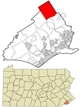 Location in Delaware County and the state of Pennsylvania. | ||
.svg.png) Location of Pennsylvania in the United States | ||
| Coordinates: 40°2′11″N 75°22′21″W / 40.03639°N 75.37250°WCoordinates: 40°2′11″N 75°22′21″W / 40.03639°N 75.37250°W | ||
| Country |
| |
| State |
| |
| County | Delaware | |
| Founded | 1682 | |
| Incorporated | 1901 | |
| Founded by | William Penn | |
| Named for | Radnorshire County, Wales | |
| Government | ||
| • Type | Board of Commissioners | |
| • Township Manager | Robert Zienkowski | |
| Area[1] | ||
| • Total | 13.79 sq mi (35.72 km2) | |
| • Land | 13.78 sq mi (35.68 km2) | |
| • Water | 0.01 sq mi (0.04 km2) | |
| Elevation | 381 ft (116 m) | |
| Population (2010) | ||
| • Total | 31,531 | |
| • Estimate (2016)[2] | 31,814 | |
| • Density | 2,309.38/sq mi (891.64/km2) | |
| Demonym(s) | Radnorite [3] | |
| Time zone | UTC-5 (EST) | |
| • Summer (DST) | UTC-4 (EDT) | |
| ZIP Code | 19087 | |
| Area code(s) | 610, 484 | |
| FIPS code | 42-045-63264 | |
| Website | http://www.radnor.com | |
Radnor Township is a township with home rule status in Delaware County, Pennsylvania, United States. It contains the unincorporated communities of Garrett Hill, Rosemont, Strafford, Villanova and Wayne as well a portion of the census designated place of Bryn Mawr and Newtown Square. As of the 2010 census, the township population was 31,531. Radnor Township lies along the Main Line, a collection of upper-middle class and upper-class Philadelphia suburbs.
Villanova University, Cabrini University, the Valley Forge Military Academy and College and Eastern University are all located within Radnor Township.
History
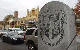
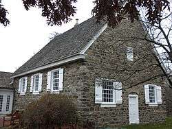
In 1681 Richard Davies purchased 5,000 acres from William Penn. These lands were sold to various purchasers and were mainly in the location of current Radnor Township.[4] The township was part of the Welsh Tract and was named for Radnorshire in Wales.[5] In 1717, the Welsh Friends erected a Quaker meetinghouse (Radnor Friends Meetinghouse) near what is now the intersection of Conestoga Road and Sproul Road at the geographic center of the township. The new town, "Radnorville", later known as the community of "Ithan" after nearby Ithan Creek, grew around the meetinghouse. The Welsh influence waned in the late 18th century as many left the area due to high taxation. Stone monuments were erected in various locations throughout the township in the late 20th century to commemorate the township's Welsh heritage.
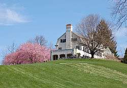
Other historic structures in Radnor Township include the Sorrel Horse, a former tavern located on Conestoga Road that sheltered George Washington and Lafayette during the Continental Army's retreat back to Philadelphia from the Battle of Brandywine.[6]
Lancaster Pike, the first toll road in the United States, connected the cities of Philadelphia and Lancaster, Pennsylvania, passing through Radnor Township, opened in 1794. That road is now part of the Lincoln Highway (U.S. Route 30). The Columbia Railroad, later part of the Pennsylvania Railroad also passed through in 1832. Thus, Radnor is one of the towns associated with the local moniker "Main Line." A separate railroad passing through Radnor Township, the Philadelphia and Western Railroad, was opened in the early 20th century. The "Main Line" railroad facilities and a portion of the P&W facilities are still used by SEPTA (the Philadelphia area's transit authority), and the "Main Line" railroad tracks are owned and used by AMTRAK.
In the 1880s, George W. Childs bought property in the community of Louella in the western part of Radnor Township, renamed the area Wayne, Pennsylvania (after American Revolutionary War hero Anthony Wayne) and organized one of the United States's first suburban developments.
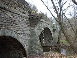
The Bridge in Radnor Township No.1, Bridge in Radnor Township No.2, Camp-Woods, Chanticleer, Downtown Wayne Historic District, Glenays, North Wayne Historic District, Pennsylvania Railroad Station at Wayne, Radnor Friends Meetinghouse, South Wayne Historic District, Wayne Hotel and Woodcrest are listed on the National Register of Historic Places.[7]
Geography
Radnor Township is located at 40°2′0″N 75°22′18″W / 40.03333°N 75.37167°W (40.033433, −75.371843).[8][9]
According to the United States Census Bureau, the township has a total area of 13.8 square miles (35.7 km²), of which 13.8 square miles (35.6 km²) of it is land and 0.07% is water.
Waterways in Radnor Township include Darby Creek, Ithan Creek, Little Darby Creek, Meadowbrook Run and Gulph Creek.
Demographics
| Historical population | |||
|---|---|---|---|
| Census | Pop. | %± | |
| 1930 | 12,263 | — | |
| 1940 | 12,012 | −2.0% | |
| 1950 | 14,709 | 22.5% | |
| 1960 | 21,697 | 47.5% | |
| 1970 | 28,782 | 32.7% | |
| 1980 | 27,676 | −3.8% | |
| 1990 | 28,703 | 3.7% | |
| 2000 | 30,878 | 7.6% | |
| 2010 | 31,531 | 2.1% | |
| Est. 2016 | 31,814 | [2] | 0.9% |
| U.S. Decennial Census[10] | |||
As of Census 2010, the racial makeup of the township was 85.8% White, 3.9% African American, 0.2% Native American, 7.9% Asian, 0.6% from other races, and 1.6% from two or more races. Hispanic or Latino of any race were 3.0% of the population .
As of the census[11] of 2000, there were 30,878 people, 10,347 households, and 6,373 families residing in the township. The population density was 2,244.3 inhabitants per square mile (866.4/km²). There were 10,731 housing units at an average density of 779.9 per square mile (301.1/km²). The racial makeup of the township was 89.55% White, 5.67% Asian, 3.09% African American, 0.08% Native American, 0.02% Pacific Islander, 0.62% from other races, and 0.98% from two or more races. 2.03% of the population were Hispanic or Latino of any race.
There were 10,347 households, out of which 29.4% had children under the age of 18 living with them, 52.9% were married couples living together, 6.8% had a female householder with no husband present, and 38.4% were non-families. 31.1% of all households were made up of individuals, and 12.1% had someone living alone who was 65 years of age or older. The average household size was 2.39 and the average family size was 3.08.
In the township the population was spread out, with 19.5% under the age of 18, 24.0% from 18 to 24, 22.5% from 25 to 44, 20.6% from 45 to 64, and 13.4% who were 65 years of age or older. The median age was 32 years. For every 100 females, there were 87.2 males. For every 100 females age 18 and over, there were 83.6 males.
According to a 2007 estimate, the median income for a household in the township was $86,812, and the median income for a family was $113,601. Males had a median income of $71,308 versus $42,652 for females. The per capita income for the township was $39,813. About 2.4% of families and 6.7% of the population were below the poverty line, including 2.9% of those under age 18 and 7.8% of those age 65 or over.
Arts and culture
Places of worship include St. David's Episcopal Church, whose graveyard, and buildings begun in 1715, are listed on the National Register of Historic Places.[12][13] Villanova Theatre serves both the university campus community and the Greater Philadelphia area. The Villanova Theatre produces four shows each academic school year presenting a wide range of dramas, comedies, and musicals. Since 1995, the department has received 49 nominations and six Barrymore Awards.[14]
Economy
Lincoln Financial Group is headquartered in Radnor Township.[15] In 2007 the company moved 400 employees, including its top executives, to Radnor from Philadelphia.[16] Other companies based in Radnor Township include, J. G. Wentworth, TV Guide magazine and Airgas.
Top employers
According to Radnor Township's 2013 Comprehensive Annual Financial Report,[17] the top employers in the city are:
| # | Employer | # of Employees | Community |
|---|---|---|---|
| 1 | Villanova University | 3,438 | Villanova |
| 2 | Radnor Township School District | 933 | Wayne |
| 3 | Eastern University | 841 | St. Davids |
| 4 | Lincoln National | 641 | Radnor |
| 5 | VWR | 448 | Radnor |
| 6 | Janssen Biotech | 403 | Radnor |
| 7 | Penn Medicine Radnor | 367 | Radnor |
| 8 | Cabrini University | 332 | Radnor |
| 9 | Jefferson Health System | 318 | Radnor |
| 10 | J.G. Wentworth | 279 | Radnor |
Education
Primary and secondary schools
Public schools
Pupils in Radnor Township attend Radnor Township School District. Radnor High School and Radnor Middle School are the sole public high and middle schools of the district. There are three elementary schools in the RTSD: Radnor Elementary School, Ithan Elementary School, and Wayne Elementary School.
Private schools
Archbishop John Carroll High School, a Roman Catholic High School in the Archdiocese of Philadelphia.Valley Forge Military Academy and College contains a boarding school program for seventh through twelfth grades. The Agnes Irwin School is an all-girls school for prekindergarten through twelfth grade. St. Katharine of Siena is a Catholic school in Wayne for students in kindergarten through eighth grade. The Hill Top Preparatory School is a school located in Ithan for students with learning disabilities in fifth through twelfth grade.
Colleges and universities
Villanova University, Eastern University, and Cabrini University are located within Radnor Township. Valley Forge Military Academy and College operates a two-year junior college.
Transportation
Highways serving Radnor Township include U.S. Route 30, which passes east-west through the township on Lancaster Avenue (part of the Lincoln Highway; Pennsylvania Route 320, which passes north-south through the township along Sproul Road and Spring Mill Road; and Interstate 476, which passes north-south through the township on the Blue Route and has an interchange with US 30.[18]
Radnor Township is serviced by SEPTA Regional Rail's Paoli/Thorndale Line which has stations within the township at Wayne, St. Davids, Radnor, and Villanova. Eastern Radnor Township is served by SEPTA's Norristown High Speed Line, an interurban heavy rail line. Within Radnor Township, there are seven stations located at Bryn Mawr, Roberts Road, Garrett Hill, Stadium - Ithan Avenue, Villanova, Radnor, and County Line.[19]
SEPTA Suburban Bus Route 106 bus runs directly through the center of Radnor Township. The route is primarily on Lancaster Avenue until the community of Radnor, where buses turn left on King of Prussia Road after passing under the Blue Route. At the intersection of King of Prussia and Radnor-Chester Roads, it turns left again onto North Radnor-Chester Road. At the intersection of Radnor-Chester Road and Lancaster Avenue, it turns right and continues on Lancaster Avenue for the rest of its time within township borders. As a result of this loop, the 106 provides bus service to students who attend Radnor High School on King of Prussia Road. The 106 serves the communities of Rosemont, Villanova, St. Davids, Radnor, and Wayne with westbound access to Paoli and eastbound access to the 69th Street Transportation Center in Upper Darby.[19][20] The 105 bus formerly drove a route similar to that of the 106, but a 2016 schedule change moved the route's western terminus to Rosemont Station, on Montrose Avenue near the border of Radnor Township and Lower Merion Township. As of 2017, the route runs parallel to Radnor Township's border on Airedale Road, but never enters the township. Occasionally, SEPTA will utilize a bus to serve stations on the Norristown High Speed Line, especially during times of inclement weather during which the tracks are rendered unusable, such as during and after extreme snowfalls. These buses will bear "NHSL" on their destination sign as opposed to a bus route number.
Notable people
- Jacob M. Appel, novelist, wrote Einstein's Beach House while living in Radnor[21][22]
- Jane Barkman Olympian (attended Radnor High School)[23]
- David Brooks (journalist) journalist (attended Radnor High School)
- Tony Campolo evangelist (attended Radnor High School)
- George W. Childs, American publisher and co-owner of the Philadelphia Public Ledger newspaper
- Mary Ellen Clark Olympian (attended Radnor High School)[23]
- Anna Moffo opera singer (attended Radnor High School)
- Helen Hope Montgomery Scott (inspiration behind The Philadelphia Story)
- Thomas F. Wilson actor / comedian (attended Radnor High School)
See also
References
- ↑ "2016 U.S. Gazetteer Files". United States Census Bureau. Retrieved Aug 13, 2017.
- 1 2 "Population and Housing Unit Estimates". Retrieved June 9, 2017.
- ↑ http://www.radnor.com/documentcenter/view/439
- ↑ Ashmeade, Henry Graham (1884). History of Delaware County, Pennsylvania. Philadelphia: L.H. Everts & Co. p. 678. Retrieved 16 June 2017.
- ↑ Espenshade, A. Howry (1925). Pennsylvania place names. State College, PA: The Pennsylvania State College. p. 246.
- ↑ "Fight Over An Old-Time Inn", New York Times, Dec. 20, 1903
- ↑ National Park Service (2010-07-09). "National Register Information System". National Register of Historic Places. National Park Service.
- ↑ "US Gazetteer files: 2010, 2000, and 1990". United States Census Bureau. 2011-02-12. Retrieved 2011-04-23.
- ↑ ftp://ftp.dot.state.pa.us/public/pdf/BPR_pdf_files/MAPS/statewide/TYPE15.pdf%5Bpermanent+dead+link%5D
- ↑ "Census of Population and Housing". Census.gov. Retrieved June 4, 2016.
- ↑ "American FactFinder". United States Census Bureau. Archived from the original on 2013-09-11. Retrieved 2008-01-31.
- ↑ St. David’s Church: Who We Are: History. Archived 2011-10-04 at the Wayback Machine.
- ↑ "Item No.:78002394 NRIS (National Register Information System)". National Park Service. Archived from the original on 2013-02-20. Retrieved 2008-09-26.
- ↑ http://www.villanovatheatre.org
- ↑ "Radnor township, Pennsylvania." U.S. Census Bureau. Retrieved on August 20, 2009.
- ↑ Blumenthal, Jeff. "Lincoln sells Delaware Investments." Philadelphia Business Journal. Wednesday August 19, 2009. Modified Thursday August 20, 2009. Retrieved on August 24, 2009.
- ↑ Township of Radnor CAFR Archived 2014-12-31 at the Wayback Machine.
- ↑ Delaware County, Pennsylvania Highway Map (PDF) (Map). PennDOT. 2015. Retrieved January 25, 2016.
- 1 2 SEPTA Official Transit & Street Map Suburban (PDF) (Map). SEPTA. Retrieved May 2, 2016.
- ↑ "106 Map" (PDF).
- ↑ Appel, JM. Phoning Home, Butler University, 2014
- ↑ Author Focus, Insight for Writers, November 2014, P. 6
- 1 2 http://www.rtsd.org/Page/35
External links
Places adjacent to Radnor Township, Delaware County, Pennsylvania | |
|---|---|
Municipalities and communities of Delaware County, Pennsylvania, United States | ||
|---|---|---|
| City | 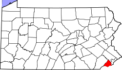 | |
| Boroughs | ||
| Townships | ||
| CDPs | ||
| Unincorporated communities |
| |
| Ghost town | ||
| Footnotes | ‡This populated place also has portions in an adjacent county or counties | |
| Counties |  | |
|---|---|---|
| Major cities | ||
| Cities and towns 50k-99k | ||
| Cities and towns 30k-50k | ||