Harrisburg–York–Lebanon, PA Combined Statistical Area
| Harrisburg–York–Lebanon, PA CSA Combined Statistical Area Southern Pennsylvania | |
|---|---|
   | |
|
| |
| Coordinates: 40°06′40″N 77°45′00″W / 40.111°N 77.750°WCoordinates: 40°06′40″N 77°45′00″W / 40.111°N 77.750°W | |
| Country | United States |
| Commonwealth | Pennsylvania |
| Largest city | Harrisburg |
| Other cities |
List
|
| Population (2010 Estimate) | |
| • Total | 1,219,422 |
| Time zone | UTC-5 (ET) |
| • Summer (DST) | UTC-4 (EDT) |
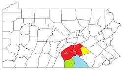
The Harrisburg–York–Lebanon, PA Combined Statistical Area (CSA) is made up of six counties in southern Pennsylvania. The United States Office of Management and Budget[1] has recognized the Harrisburg and York areas along with several Metropolitan Statistical Areas to make a Combined Statistical Area, located in southern Pennsylvania. As of the 2010 United States Census[2] the CSA had a population total of 1,219,422, and ranked 3rd most populous in the state of Pennsylvania and 43rd most populous in the United States.
Components of the Combined Statistical Area
- Harrisburg–Carlisle, PA Metropolitan Statistical Area
- Cumberland County population 235,406
- Dauphin County population 268,100
- Perry County population 45,969
- Lebanon, PA Metropolitan Statistical Area
- Lebanon County population 133,568
- Gettysburg, PA Metropolitan Statistical Area
- Adams County population 101,407
- York–Hanover, PA Metropolitan Statistical Area
- York County population 434,972
See also
References
- ↑ "Office of Management and Budget | The White House". whitehouse.gov. Retrieved 2014-05-25.
- ↑ "2010 Census". census.gov. Retrieved 2014-05-25.
This article is issued from
Wikipedia.
The text is licensed under Creative Commons - Attribution - Sharealike.
Additional terms may apply for the media files.