St. Marys, Pennsylvania
| Saint Marys, Pennsylvania | |
|---|---|
| City | |
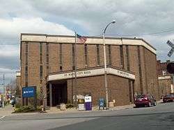 Saint Marys City Hall | |
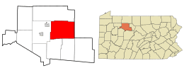 Location in Elk County and the U.S. state of Pennsylvania. | |
| Coordinates: 41°25′40″N 78°33′40″W / 41.42778°N 78.56111°WCoordinates: 41°25′40″N 78°33′40″W / 41.42778°N 78.56111°W | |
| Country | United States |
| State | Pennsylvania |
| County | Elk |
| Settled | 1804 |
| Incorporated (borough) | 1848 |
| Incorporated (city) | 1992 |
| Government | |
| • Mayor | Lou Radkowski (R) |
| Area[1] | |
| • Total | 99.52 sq mi (257.76 km2) |
| • Land | 99.32 sq mi (257.24 km2) |
| • Water | 0.20 sq mi (0.52 km2) |
| Elevation | 1,666 ft (508 m) |
| Population (2010) | |
| • Total | 13,070 |
| • Estimate (2016)[2] | 12,499 |
| • Density | 125.84/sq mi (48.59/km2) |
| Time zone | Eastern (EST) |
| • Summer (DST) | EDT |
| Zip code | 15857 |
| Area code(s) | 814 Exchanges: 781,834 |
| FIPS code | 42-67344 |
| Website | City of Saint Marys |
St. Marys is a city in Elk County, Pennsylvania, United States. The population was 13,070 at the 2010 census. Originally a small town inhabited by mostly Bavarian Roman Catholics, it was founded December 8, 1842. It is home to Straub Brewery and the first Benedictine convent in the United States. In 1992, the borough of St. Marys absorbed the surrounding township of Benzinger and incorporated as a city.[3]
St. Marys lies in the center of Pennsylvania's elk country. It is one of the few places east of the Mississippi River that allows hunting of wild elk. The area is known for its access to outdoor activities, including trout streams and state hunting lands inside the city limits.
History
The town was founded as Marienstadt (Mary's City). Many historic structures are located within the boundaries of the St. Marys Historic District, added to the National Register of Historic Places in 1998. The Decker's Chapel and John E. Weidenboerner House are also listed on the National Register of Historic Places.[4]
Geography
St. Marys is located at 41°26′15″N 78°32′34″W / 41.437600°N 78.542724°W (41.437600, -78.542724).[5]
According to the United States Census Bureau, the city has a total area of 99.5 square miles (258 km2), of which 99.3 sq mi (257 km2) is land and 0.2 sq mi (0.52 km2) (0.16%) is water. Most of that area is unurbanized, and the large size is due to the city's 1992 merger with surrounding Benzinger Township.[3] The city is at a relatively high elevation of 1,666 ft (508 m) above sea level. The city's territory is bordered by Jones Township to the north, Cameron County to the east, Fox and Jay Townships to the south, and Ridgway Township to the west.
Demographics
| Historical population | |||
|---|---|---|---|
| Census | Pop. | %± | |
| 1860 | 692 | — | |
| 1870 | 1,084 | 56.6% | |
| 1880 | 1,501 | 38.5% | |
| 1890 | 1,745 | 16.3% | |
| 1900 | 4,295 | 146.1% | |
| 1910 | 6,346 | 47.8% | |
| 1920 | 6,967 | 9.8% | |
| 1930 | 7,423 | 6.5% | |
| 1940 | 7,653 | 3.1% | |
| 1950 | 7,846 | 2.5% | |
| 1960 | 8,065 | 2.8% | |
| 1970 | 7,470 | −7.4% | |
| 1980 | 6,417 | −14.1% | |
| 1990 | 5,511 | −14.1% | |
| 2000 | 14,502 | 163.1% | |
| 2010 | 13,070 | −9.9% | |
| Est. 2016 | 12,499 | [2] | −4.4% |
| Sources:[6][7][8] | |||
As of the census[9] of 2010, there were 13,070 people, 5,579 households, and 3,695 families residing in the city. The population density was 131.6 people per square mile (51.4/km2). There were 6,124 housing units at an average density of 61.7 per square mile (24.1/km2). The racial makeup of the city was 98.5% White, 0.3% African American, 0.05% Native American, 0.4% Asian, 0.05% Pacific Islander, 0.1% from other races, and 0.6% from two or more races. Hispanic or Latino of any race were 0.4% of the population.
There were 5,579 households, out of which 26% had children under the age of 18 living with them, 52.8% were married couples living together, 9.1% had a female householder with no husband present, and 33.8% were non-families. 29.8% of all households were made up of individuals, and 14.2% had someone living alone who was 65 years of age or older. The average household size was 2.29 and the average family size was 2.82.
In the city, the population was spread out, with 20.1% under the age of 18, 59.5% from 18 to 64, and 20.4% who were 65 years of age or older. The median age was 45.6 years.
The median income for a household in the city was $45,802, and the median income for a family was $55,045. Males had a median income of $41,968 versus $29,489 for females. The per capita income for the city was $24,208. About 7% of families and 11.4% of the population were below the poverty line, including 20.3% of those under age 18 and 10.9% of those age 65 or over.
Transportation
The city's airport is St. Marys Municipal Airport (IATA: STQ) in the city's southeastern quadrant. Currently, it is a general aviation airport; however, commercial airlines are showing interest because of the new terminal building and equipment upgrades.
The city's main highways are PA 255 and PA 120. Bus service is provided by ATA; a daily Fullington Trailways bus line runs through St. Marys as well.
Education
Public school district
Saint Marys Area School District has three elementary schools, one of which, the South St. Marys Street Elementary School, is located within the city. It houses kindergarten through fifth grade classes for public school students within the city limits; similar services are provided to residents of Fox Township and Jay Township by, respectively, the Fox Township Elementary School in Kersey and the Bennett's Valley Elementary School in Weedville.
The St. Marys Area Middle School and the St. Marys Area High School are located next to each other on a large complex near the edge of the city. Grades 6-8 are taught at the middle school, and grades 9-12 are taught at the high school. Saint Marys Area School District was ranked 165th out of 498 Pennsylvania school districts by the Pittsburgh Business Times in 2012.
Catholic school system
St. Marys Catholic Elementary School has one building, which is connected to Queen of the World Church. In 2002, an addition was built, adding four classrooms and a gymnasium. It also recently had a playground added. It houses grades pre-K through 5.
St. Marys Catholic Middle School, is located in the same building as the Elk County Catholic High School. The middle school formally occupied the old Saint Mary's Parochial school building that was built in the early 1950s. Elk County Catholic High School, formally Elk County Christian High School, houses grades 6-12. It was built in 1961.[10]
Until the early 2000s, the Catholic school system's elementary and middle schools, then known respectively as the Queen of the World School and the St. Marys Parochial School, each served all students up through eighth grade who attended their respective Catholic churches, as did the Sacred Heart School. When the school system was reworked into its current format due to declining attendance, the Sacred Heart School was closed.
Landmarks
Decker's Chapel, built by Michael Decker after a back injury, has been called the smallest chapel in America. It is located on South St. Marys Road.
St. Joseph Monastery, home of the Benedictine Sisters of Elk County, was the oldest Benedictine women's religious order in the United States, founded in 1852. In 2013, the Sisters voted unanimously to dissolve the community. The building remains.
Straub Brewery, was founded in St. Marys in 1872 by Peter Straub (1850-1913) of Felldorf, Württemberg, Germany, who purchased the Benzinger Spring Brewery from his father-in-law, Francis Xavier Sorg. Brewing continuously since that time, Straub is the third oldest brewery in the United States and considered an American Legacy Brewery™. It is still owned and operated by the original founding family, now in its seventh generation. Straub is also the smallest pre-Prohibition brewery still in business in the United States.Tours of the brewery include a stop at the "Eternal Tap," at which a person can drink a free glass of Straub beer.
The Bucksgahuda and Western Railroad is a 2 ft (610 mm) narrow gauge[11] railroad run by enthusiasts.
Media
- The Daily Press is St. Mary's daily newspaper.
- WDDH (FM 97.5) is a country music station based in Ridgway and the most powerful station in the region, being heard as far north as Cattaraugus County, New York.
- WKBI (AM 1400) operates an Adult Standards/Oldies format. Also heard on 94.5 FM, W233BS.
- WKBI (FM 93.9) operates an Adult Contemporary music format. WKBI-AM/FM was sold in early 2013 by longtime owner Cary Simpson to Laurel Media, Inc/WDDH 97.5
WKBI-AM/FM and WDDH 97.5 have studios located in Ridgway.
Notable people
- George Albee, psychologist
- Joe Beimel, baseball player
- Dan Conners, professional football athlete; linebacker, Oakland Raiders
- Chuck Daly, basketball coach (high school, college, NBA, Olympics)
- Joan Marie Engel, United States Navy Flag Officer
- Jeff Lloyd, professional football athlete; defensive end, Buffalo Bills & Kansas City Chiefs
- Edward C. Meyer, Chief of Staff, United States Army 1979-83
- Anthony Joseph Schuler, American Roman Catholic bishop
- Joanna Shields, Businesswoman and UK Minister for Internet Safety and Security
References
- ↑ "2016 U.S. Gazetteer Files". United States Census Bureau. Retrieved Aug 13, 2017.
- 1 2 "Population and Housing Unit Estimates". Retrieved June 9, 2017.
- 1 2 "Saint Marys City Code - History" (PDF). 2007-12-17. Archived from the original (PDF) on October 22, 2006. Retrieved 2008-07-22.
- ↑ National Park Service (2009-03-13). "National Register Information System". National Register of Historic Places. National Park Service.
- ↑ "US Gazetteer files: 2010, 2000, and 1990". United States Census Bureau. 2011-02-12. Retrieved 2011-04-23.
- ↑ "Census of Population and Housing". U.S. Census Bureau. Retrieved 11 December 2013.
- ↑ "American FactFinder". United States Census Bureau. Retrieved 2008-01-31.
- ↑ "Incorporated Places and Minor Civil Divisions Datasets: Subcounty Resident Population Estimates: April 1, 2010 to July 1, 2012". Population Estimates. U.S. Census Bureau. Archived from the original on 17 June 2013. Retrieved 11 December 2013.
- ↑ "American FactFinder". United States Census Bureau. Retrieved 2011-05-14.
- ↑ http://www.eccss.org/
- ↑ "Steamlocomotive.com - Pennsylvania". steamlocomotive.info. Retrieved 20 April 2018.
External links
| Wikimedia Commons has media related to St. Marys, Pennsylvania. |

- City of St. Marys Official Website
- Saint Marys Area Chamber of Commerce
- Saint Marys at City-Data.com
- Bucksgahuda and Western Railroad - official website

Municipalities and communities of Elk County, Pennsylvania, United States | ||
|---|---|---|
| City |  | |
| Boroughs | ||
| Townships | ||
| CDPs | ||
| Unincorporated communities | ||