East Fallowfield Township, Chester County, Pennsylvania
| East Fallowfield Township | |
|---|---|
| Township | |
 | |
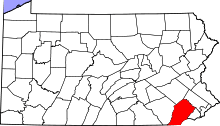
 Location in Chester County and the U.S. state of Pennsylvania. | |
| Coordinates: 39°57′00″N 75°48′38″W / 39.95000°N 75.81056°WCoordinates: 39°57′00″N 75°48′38″W / 39.95000°N 75.81056°W | |
| Country | United States |
| State | Pennsylvania |
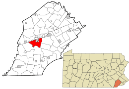
| County | Chester |
| Area[1] | |
| • Total | 15.61 sq mi (40.44 km2) |
| • Land | 15.51 sq mi (40.17 km2) |
| • Water | 0.10 sq mi (0.27 km2) |
| Elevation | 515 ft (157 m) |
| Population (2010) | |
| • Total | 7,449 |
| • Estimate (2016)[2] | 7,529 |
| • Density | 485.40/sq mi (187.41/km2) |
| Time zone | UTC-5 (EST) |
| • Summer (DST) | UTC-4 (EDT) |
| Area code(s) | 610 |
| FIPS code | 42-029-21104 |
| Website |
www |
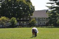
East Fallowfield Township is a township in Chester County, Pennsylvania, United States. The population was 7,449 at the 2010 census.
History
East Fallowfield is said to be named for Lancelot Fallowfield, one of the first purchasers of land from William Penn.[3]
The Nelson P. Boyer Barn was listed on the National Register of Historic Places in 1985, and delisted in 1991 after demolition.[4] The John Bailey Farm, Brandywine Building and Loan Assoc. Rowhouses, Bridge in East Fallowfield Township, Harry DeHaven House, Edward Dougherty House, Philip Dougherty House, Philip Dougherty Tavern, Drovers Inn, Ercildoun Historic District, Joseph Gladden House, Glen Rose Historic District, John Hanna Farm, Mortonville Hotel, Mansel Passmore House, Isaac Pawling House, Martha Pennock House, Lukens Pierce House, Powell Farm, John Powell House, Joshua Pusey House, David Scott House, Thomas Scott House, Speakman No. 1, Speakman No. 2, Mary Ann Pyle Bridge, Robert Steen House, Rev. Joshua Vaughan House, Asa Walton House, John Wentz House, White Horse Tavern, Robert Wilson House, and Robert Young House are listed on the National Register of Historic Places.[4]
Geography
According to the United States Census Bureau, the township has a total area of 15.7 square miles (41 km2), all of it land.
Adjacent townships
Seven townships share boundaries with East Fallowfield Township. They are:
- Caln Township (northeast)
- West Bradford Township (east)
- Newlin Township (southeast)
- West Marlborough Township (south)
- Highland Township (west)
- Sadsbury Township (northwest)
- Valley Township (north)
East Fallowfield Township also shares boundaries with the boroughs of Modena and South Coatesville.
Demographics
At the 2010 census, the township was 82.4% non-Hispanic White, 9.3% Black or African American, 0.1% Native American, 1.8% Asian, and 2.3% were two or more races. 4.6% of the population were of Hispanic or Latino ancestry.[5]
As of the census[6] of 2000, there were 5,157 people, 1,801 households, and 1,458 families residing in the township. The population density was 328.9 people per square mile (127.0/km²). There were 1,860 housing units at an average density of 118.6/sq mi (45.8/km²). The racial makeup of the township was 88.38% White, 9.13% African American, 0.14% Native American, 0.43% Asian, 0.12% Pacific Islander, 0.47% from other races, and 1.34% from two or more races. Hispanic or Latino of any race were 1.69% of the population.
There were 1,801 households, out of which 37.3% had children under the age of 18 living with them, 69.1% were married couples living together, 7.4% had a female householder with no husband present, and 19.0% were non-families. 15.5% of all households were made up of individuals, and 5.7% had someone living alone who was 65 years of age or older. The average household size was 2.82 and the average family size was 3.14.
In the township the population was spread out, with 27.7% under the age of 18, 6.5% from 18 to 24, 30.1% from 25 to 44, 25.0% from 45 to 64, and 10.8% who were 65 years of age or older. The median age was 38 years. For every 100 females, there were 101.0 males. For every 100 females age 18 and over, there were 97.2 males.
| Historical population | |||
|---|---|---|---|
| Census | Pop. | %± | |
| 1930 | 1,406 | — | |
| 1940 | 1,542 | 9.7% | |
| 1950 | 1,795 | 16.4% | |
| 1960 | 2,745 | 52.9% | |
| 1970 | 3,487 | 27.0% | |
| 1980 | 3,962 | 13.6% | |
| 1990 | 4,433 | 11.9% | |
| 2000 | 5,157 | 16.3% | |
| 2010 | 7,449 | 44.4% | |
| Est. 2016 | 7,529 | [2] | 1.1% |
| [7] | |||
The median income for a household in the township was $60,902, and the median income for a family was $66,619. Males had a median income of $42,731 versus $30,545 for females. The per capita income for the township was $25,376. About 2.2% of families and 3.8% of the population were below the poverty line, including 5.0% of those under age 18 and 6.8% of those age 65 or over.
References
- ↑ "2016 U.S. Gazetteer Files". United States Census Bureau. Retrieved Aug 13, 2017.
- 1 2 "Population and Housing Unit Estimates". Retrieved June 9, 2017.
- ↑ Gannett, Henry (1905). The Origin of Certain Place Names in the United States. Govt. Print. Off. p. 112.
- 1 2 National Park Service (2010-07-09). "National Register Information System". National Register of Historic Places. National Park Service.
- ↑ https://www.usatoday.com/news/nation/census/profile/PA
- ↑ "American FactFinder". United States Census Bureau. Archived from the original on 2013-09-11. Retrieved 2008-01-31.
- ↑ http://www.dvrpc.org/data/databull/rdb/db82/appedixa.xls